Book Review: 1421, The Year China Discovered the World, by Gavin Menzies, Bantam Press, 2002
Review By Dan Gibson
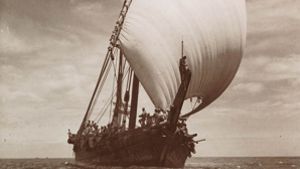
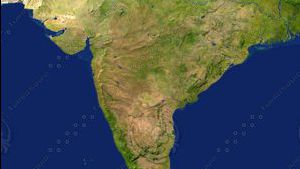
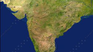
This book puts forward the claim that Chinese admirals traveled around the world visiting every corner of the globe in 1421. In 520 pages, Menzies puts together a fantastic account of seven incredible voyages. Although scholars of Chinese history have long known of Admiral Zheng He’s voyages, Menzies is the first person to claim that the Chinese sailed around the whole world. Most scholars believe that the fleet of treasure ships commissioned by Chinese Emperor Zhu Di sailed only in the Indian Ocean and South China Seas. So what evidence to we have that the treasure fleets sailed around the world? Menzies pieces together many types of evidence, but do they stand up to scrutiny? Let’s examines some.

First, Menzies claims on page 103 that there are inscriptions on a large red sandstone rock some 3 meters high, standing on the Cape Verde Islands in the Atlantic, which he photographed. Interestingly enough he does not provide us with any copies of his photographs, or even line drawings of the inscriptions, which he claims are in the Malayalam language (a language spoken by millions of people in south India). Menzies then claims that the Chinese carved these Malayalam inscriptions, which he never translates for us. He simply mentions them and then moves on to ancient maps. Unfortunately, red sandstone is unknown on the islands. The best rock with inscriptions has been photographed.
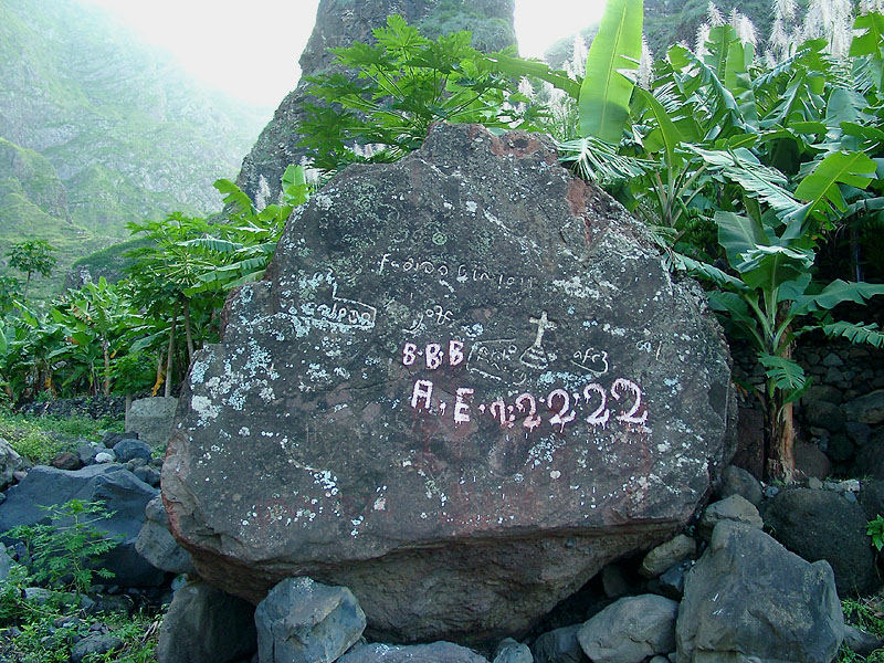
https://www.bela-vista.net/Pedra-Nossa-Senhora-e.htm
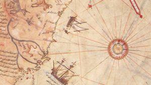
Much of Menzies’ claims are based on the Piri Reis map, drawn by a Turkish admiral in 1512. On page 116 Menzies asks “…who originally provided the information to enable Patagonia to be drawn on the Piri Reis and how did he obtain it?” Menzies infers and wants us to believe that the Turks obtained their information from the Chinese.
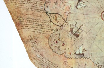
Bottom left corner of the Piri Reis map showing boats around the southern part of South America
Unfortunately, Menzies doesn’t seem to have actually had a good look at the writing on the Piri Reis map, for the Turkish admiral clearly states on each part of his world map from where he obtained the information. In the corner of the map, near South America and Antarctica is the following inscription in Turkish (using the Arabic script):
“This section shows in what way this map was drawn. In this century there is no map like this map in anyone’s possession. The hand of this poor man has drawn it and now it is constructed. From about twenty charts and Mappae Mundi: these are charts drawn in the days of Alexander, Lord of the Two Horns, which show the inhabited quarter of the world; the Arabs name these charts Jaferiye-from eight Jaferiyes of that kind and one Arabic map of Hind, (India) and from the maps just drawn by four Portuguese … and also from a map drawn by Colombo in the western region I have extracted it. By reducing all these maps to one scale this final form was arrived at. So that the present map is as correct and reliable for the Seven Seas as the map of these our countries is considered correct and reliable by seame_n.”
This part of the map was clearly drawn from several other earlier maps. The Caribbean section was taken from a map made by Columbus. The South America section was drawn from maps made during the time of Alexander the Great and his Generals who followed. It mentions Alexander, Lord of the Two Horns, (This could refer to Alexander the Great, or Ptolemy II, who collected maps at the Great Library in Alexandria.) It clearly mentions that Arabs created the original maps of this part of the world during the time of the Alexanders, not the Chinese less than a century earlier. Much of Menzies’ arguments fail here.
What is puzzling about this is that Menzies lists a number of scholars in his footnotes that all clearly communicate what the notes on the side of the map state. Is Menzies deliberately trying to mislead us by failing to tell us about them or was his research so sloppy that he missed such an important point (which undermines every reference he makes to the Peri Reis Map.) Perhaps Menzies was so intent in trying to find evidence for the Chinese that he simply missed such an important statement.
I believe that Menzies has done what many others before him have done. That is: assume that they are researching the very first cross-Atlantic voyages, thus not taking into account that others may have been there before. There is no question that the Chinese sailed into the southern hemisphere (Chie Thang Shu is a good example). They assuredly sailed through the Philippines and may have explored Australia and New Zealand (such as Xi Uang Ji’s voyage recorded in the Hsi-Yang-Chi). But this does not prove that the treasure fleets sailed to the Antarctica and South America.
A few pages later, Menzies claims that Megellan knew where to find the straight that separated South America from Antarctica, and that he sailed straight for it presumably because he had maps showing where the straight was. He then infers that the Portuguese gained this information from the Chinese, rather than informing us that Megallan had an Arab navigator on board who ‘guided’ him on his journey.
Menzies’ chapter on the first colony in America proposes that a Chinese junk sank in the Sacramento River and that the survivors built a colony about seventy miles north-west of the wreck. Menzies quotes several studies, but does not provide us with the names of these studies, or indeed any footnotes that would help a researcher check out his claims. This lack of footnoting is very frustrating as the reader cannot check further into Menzies’ sources. No matter, if the evidence is true, then it points to a single Chinese junk being blown off course across the Pacific where it finally crashes on the North American coast. The sailors leave the wreck and seek shelter in California, eventually starting their own colony inland, far from the sea. If the junk had been part of a huge treasure fleet, then I would assume that other ships from the fleet would have rescued the sailors. If the Chinese wanted to establish a trading colony, then I would also assume that they would have built their colony near the shore where further trade could have been carried out with China. So we apparently have evidence of Chinese in California, but no clear evidence that a treasure fleet ever visited those shores.
In the chapters that follow, the process of making and using lacquer is explored, suggesting that the Chinese and the Mayans used an identical method. We must agree that this is possible evidence that there was communication between South America and China but this kind of communication could have been made through Arab merchants visiting both civilizations, rather than direct contact between them. The rest of the chapter presents long argued opinions on cross-Atlantic trade, this time however with a Chinese twist. Did the Chinese actually trade across the Pacific? Perhaps, but there is no direct evidence that the great treasure fleets of Zheng He ever took part in this trade.
Menzies continues his errors into the next chapter, noting on page 243 “the Portuguese simply did not have the capacity to survey the islands with such accuracy - for the cartography of Antilia was amazingly good. I concluded that it could only have been the Chinese.” This type of argument lacks credibility. Just because the Portuguese possessed maps of greater accuracy than their scientific ability could produce is not evidence that the Chinese made them. If it wasn’t the Chinese, then it could have been anyone, including the Arabs who had long sailed the world and who may have been the first to develop the science of astronomy, giving us the names of 360 stars. On the other hand it could have been the Phoenicians long before this who were also renown as world sea travelers. The proofs given by Menzies only bring us to the conclusion that the Americas had been visited before the Portuguese arrived. This is no surprise, since the ancient Egyptian pharaohs possessed items and plants that were native only to the Americas. Obviously someone had been crossing the seas for many centuries. But was it the Chinese? Menzies fails to prove this.
The same goes for the following chapter where Menzies describes (pg 276) how explorer after explorer in the New World came across fair skinned people with white tunics. Were these Chinese as the book supposes or were these people of other races? This kind of speculation is interesting, but it is certainly not conclusive proof the Chinese ever arriving in the Caribbean.
In the chapter titled Settlement in North America, Menzies quotes Verrazzano, who arrived at Rhode Island in 1524. He describes the local people as: “the color of brass, some of them incline more to whiteness: others are of yellow colour, of comely visage, with long and black hair, which they are very careful to trim and deck up; they are black and quick eyed, and of sweet and pleasant countenance… The women are of the conformity and beauty; very handsome and well favoured, of pleasant countenance and comely to behold; they are as well-mannered and continent as any woman, and of good education ….[women] use other kinds of dressing themselves like unto the women of Egypt and Syria; these are of the elder sort: and when they are married, they wear divers toys [jeweler] according to the usage of the people of the East, as well men as women.” Francis I, King of France to Verrazzano, quoted in D. B. Quinn (ed) North American Discovery, Harper and Row, 1971
On page 285 Menzies protests that Syrian or Egyptian sailors would never have reached the Atlantic, and that their women would not have been taken on long voyages. If only Menzies had bothered to read the notes on the side of the Piri Reis map, where it boldly proclaims that Arab sailors visited the shores of North and South America during the time of the Ptolemy rulers.
Menzies has put together some interesting evidence, such as the carved stone on the island of Corvo off the coast of Portugal which displays a man seated upon a horse, his head uncovered and bald, his left hand on his horse and his right hand pointing towards the west. Below the rock is writing that has not been translated. Sorry, no pictures, no pen drawings, and no further mention of it, not even on the website.
Menzies’ next chapter on an expedition to the North Pole is based solely on the fact that the Chinese had square rigged shipped and would have had a hard time sailing west, unless they had traveled around Greenland. He then uses the highly questionable Vineland map as his evidence, and a line in Columbus’s book to Pope Pius II “History of Remarkable Things that Happened in my Time.” Where he states “Men have come hither (to Iceland) from Cathay in the Orient.” Cathay was the name that Marco Polo used for the Orient, particularly China. Along with this, he mentions that Needham also states that there are more than 20 different ancient claims that the Chinese reached the North Pole. (Of course the Chinese could have simply journeyed north overland from China to get there, and had no need to sail all around the world to accomplish this.)
On the other hand, the ancient Arab sailors had lug sails, or triangular sails that allowed their ships to tack, and sail virtually against the wind. They would have had much less of a problem crossing the Atlantic than the slow square rigged junks that Menzies is trying to convince us about.
In chapter fifteen Menzies continues along the same logic. He mentions the Portuguese Cantino map of 1502 and then states …"My belief that it was based on information obtained form the Chinese voyages of 1421 -3 arose from Portuguese historian Antonio Galvao’s comment about the map…." Which simply states that they had maps of the east. In the very next paragraph Menzies quotes from King Joao II of Portugal to his explorers “He recommended him very much to inquire whether beyond the Cape of Good Hope it was possible to navigate to India…. Then the king sent two of his trustworthy men who could speak Arabic well and were experienced travelers….”
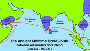
No mention of speaking Chinese, just Arabic. It appears that Menzies has totally missed the fact that the Arabs were the sea merchants of the Indian Ocean (and beyond) from the time of Christ until the 1500’s. He totally missed the fact that during the period just before the Chinese fleet set sail there were over 100,000 Arab and Persian merchants living in Canton China! There were so many foreign merchants that strife had arisen between them and the Chinese. This is all well documented. It was Arabs who traded between Europe, India and China. It was Arabs who invented navigation and much of astronomy. It was Arabs who had mapped much of the globe. It was Arabs who brought merchant trade to China. And so the Portuguese King advised the explorers to take along Arabic speaking men not Chinese speaking men! But for some reason Menzies thinks this is somehow proof of a Chinese connection!
Menzies then goes on to describe at great length how the Chinese told time in order to calculate longitude. He talks about “as far back as 721 AD the Chinese had realized that the length of the sun’s shadow varies not only with the time of day but with the time of year and latitude of the observation points.” Bravo. But ancient obelisks and sun dials have been set up all over the Middle East, supposedly with the sole purpose of measure time using shadows.
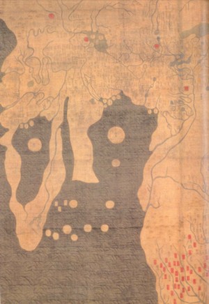
The Kangnido Map of 1402 by Ch'uan Chin and Li Hui demonstrates the accuracy of Chinese Map mapping.
India is on the right, the Arabian Peninsula in the center and Africa, filled with a lake is on the left. Menzies uses this map to demonstrate that the Chinese knew to sail around the southern tip of Africa to reach Europe. He fails to point out the miserable map-mapping skills of the Chinese in 1402, but claims that they accurately charted the entire world with greatest accuracy 19 years later!
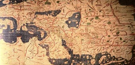
Selected area of Al Idrisi's map with Arabia in the center.
On page 332 Menzies claims to have examined a collection of old Arab maps and states, “the best Arabic medieval maps, such as those of Al Idrisi, bear no comparison in detail or accuracy to the Cantino of 1502. Although the Arabs understood how to calculate longitude by lunar eclipse, they never mastered how to measure time, with the necessary accuracy, something that the Chinese achieved, and hence the Arabs could not have produced the Cantino or the Waldseemuller chart.”
And so in two sentences, Menzies dismissed an age old question of who developed these technologies first. Rather than researching the writings of various scholars on either side of this argument, Menzies looks at the Arab maps in the British Library and dismissed the Arabs. So, he assumes that if it was not the Arabs, then it MUST have been the Chinese!
In Chapter 16 Menzies begins to describe to us the world from a 1470’s Portuguese perspective, admitting that “Arabs had sailed over the whole known world for centuries.” He admits that the Portuguese copied Arab ship designs in order to begin their sailing ventures. He admits that the Portuguese solved the problems of latitude with help from the Arabs, and that they used the Arab names for the star navigation, Arab charts and Arab navigators to guide them. He admits that the Portuguese learned from the Arabs that the Spice Islands could be reached by sailing west, rather than east. And then, much to our surprise, he insists that the maps that the Portuguese used were of Chinese origin. He states “One can only imagine the extraordinary impact these carts, based on the Chinese voyages of 1421 to 1423 must have had on the Europeans …” Excuse me, but I fail to catch the connection. After 14 pages of describing Arab accomplishments, the Chinese are suddenly credited with the production of the maps! Menzies’ only Portuguese-Chinese connection is through Da Conti, who returned from the East by 1424, in disguise because he had converted to Islam. But Menzies is convinced that Da Conti sailed with the Chinese around Africa to the shores of Portugal. Interestingly enough, Da Conti’s journals make no mention of this trip, neither the Chinese, nor Chinese navigators. Where did Menzies get his facts? He didn’t. He simply implies that the Portuguese must have gotten their maps from the Chinese.
Menzies’ argument can be summed up by a statement he makes on page 415. “Who but the Chinese with six centuries experience of ocean navigation could have reached the Antarctic?” Well, lets see… there were the Arabs, Persians, Greeks, maybe even the Phoenicians. But Menzies is convinced that it was the Chinese. He argues that the Portuguese must have had maps to guide them, but he never once considers that the Chinese may have also had maps to guide them. 1421 is a very late date to discover the world, as other nations had been sailing the oceans of the world for centuries before this.
In conclusion, let’s ask another question. What nations of the world were very self focused, occupied by invading nomadic barbarians for great periods of time, and had periods of history where leaving their shores was strictly forbidden? Ancient China comes immediately to mind. From 618 AD to 907 AD all foreign relations were banned in China. From 1264 AD - 1356 AD sea trade was slowly expanded so that Chinese junks began sailing to East China seas once again.
Then in 1421 China broke with their traditional history and launched a fleet of merchant ships. The huge fleet of Admiral Zheng He made at least one voyage around the Indian ocean before China again became self focused. In 1433 this exploration suddenly ceased. The emperor banned all merchants from going abroad. Sea travel was forbidden once again and all exploration suddenly ceased. Did China travel the world, carefully mapping out distant coasts along Antarctica and America? Menzies’ book is the only one suggesting such an idea, and he does little to convince historians that he has uncovered any solid evidence to support his claims.


Page Discussion
Membership is required to comment. Membership is free of charge and available to everyone over the age of 16. Just click SignUp, or make a comment below. You will need a user name and a password. The system will automatically send a code to your email address. It should arrive in a few minutes. Enter the code, and you are finished.
Members who post adverts or use inappropriate language or make disrespectful comments will have their membership removed and be barred from the site. By becoming a member you agree to our Terms of Use and our Privacy, Cookies & Ad Policies. Remember that we will never, under any circumstances, sell or give your email address or private information to anyone unless required by law. Please keep your comments on topic. Thanks!