It has been suggested by some of our readers, that the Nabataeans may have reached Antarctica, and even South America. This amazing claim is based on a theory that revolves around Piri Re’is map of 1513. The theory goes like this:
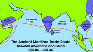
If the Nabataeans were the principle sea traders for the Ptolomies, bringing them goods from the Far East and thus making Alexandria the richest seaport of their time, then Piri Re’is map of 1513, which was based on the median that passes through Alexandria, may have been originally drawn from a Nabataean map. According to Charles Hapgood, who wrote the book Maps of the Ancient Sea Kings, the map in question dates from 1513 and was made by a man named Piri Ibn Haji Memmed, otherwise known as Piri Re’is. This man was an Admiral in the Turkish navy, and he made his map from approximately 20 very ancient source maps, including maps captured from the Portuguese. He claimed the western portion of the map was obtained from Christopher Columbus. He also claimed some of the source maps were dated from the time of Alexander and that some of the others were based upon mathematics.
Charles Hapgood presents us with the idea that this map was drawn using the Equidistant projection method. Instead of using the standard markings of latitude and longitude that are common on todays maps, the map used the “portolan” style” of map drawing. Thus the map was drawn using a series of points from which a series of lines radiate outward. One such mechanism for drawing these maps was the “Eight Wind” system. Others including the Sixteen Wind system were also used. The reasons for such drawing methods have long been assumed to benefit the mariner because these lines seem to correspond to the points of the compass.
It is interesting to note that other portolan maps that surfaced in the AD 1300’s were highly accurate mariners’ charts of the Mediterranean area, sometimes including the Black Sea, made by Portuguese, Venetian, Spanish, Catalan and Arab seamen. They are extremely beautiful maps, with a high degree of accuracy. How could medieval sailors, with no navigational aids but the compass, have prepared such accurate charts? It seems that these highly accurate maps suddenly appeared in Europe without any evidence of earlier development, and thus, some people assume that the methods used to make them were developed in a much earlier time. Interestingly enough, throughout the next several hundred years these maps did not show any further development. Further to this, these maps are all drawn from the same scale. This suggests to some, that the maps were not being developed as a result of mariner survey activity, and that the lack of variance in scale may suggest that the understanding of these maps, and the mathematical principles behind them, was not understood but rather copied from one or several original maps. The Finnish scholar, Nordenskjold, the leading authority on portolan maps, claims that all portolanos appear to be based on a single prototype, that has since vanished. It is assumed that the source map would have been an ancient Greek map. The problem with this, is that back in 200 B.C - 100 AD the knowledge of plane geometry and trigonometry had not been developed in the Greek world. And without knowledge of geometry and trigonometry, no one could have produced such accurate maps.
Charles Hapgood noted this when performing a detailed analysis of Piri Re’is’ map. Working with students from Keene State College, as well as with cartographers from the US Air Force he produced a detailed analysis, along with several interesting observations.
The map is composed of a large number of separate source maps. Piri Re’is claimed to have used about 20 source maps. Among them, he wrote, were eight maps of the world done in the time of Alexanders (400 B.C. to 100 AD), an Arab map of India, four Portuguese maps of the Indian Ocean and China, and a map drawn by Colombus in the western region.” He did not, however, say what the other six source maps were.The resulting map provides remarkably accurate latitude and longitude locations of coastal features in Africa, North and South America, and a portion of Antarctica. The source maps must have utilized the principles of plane geometry and an ability to account for the curvature of the earths surface. The knowledge of longitude suggests that the people who drew the maps used a mechanism that was currently unknown to the west at that time. (This ability to determine longitude with any degree of accuracy was not known at this time in Europe, although it may have been known to ancient Arab mariners. The most interesting thing, is that the map in question is based on an equidistant projection which has its center on the meridian of Alexandria in Egypt.
Mr. Hapgood also presented a number of exhibits in his book to support these claims. He also presented a wide range of empirical evidence to back up these points. Piri Re’is Map of 1513 contains accurate mapping of the coastline of the Americas, and amazingly enough, a portion of Antarctica. (There is significant debate about whether or not this is actually Antarctica.) Mr. Hapgood himself comments that if this was the only evidence we had that the ancients had mapped Antarctica it would be questionable.
The degree of accuracy contained in the Piri Re’is map is extraordinary. Given that the author of this map himself claimed to have based this map, not on his own surveying skills, but rather on ancient maps, serious questions about the development of navigation as we currently understand it.
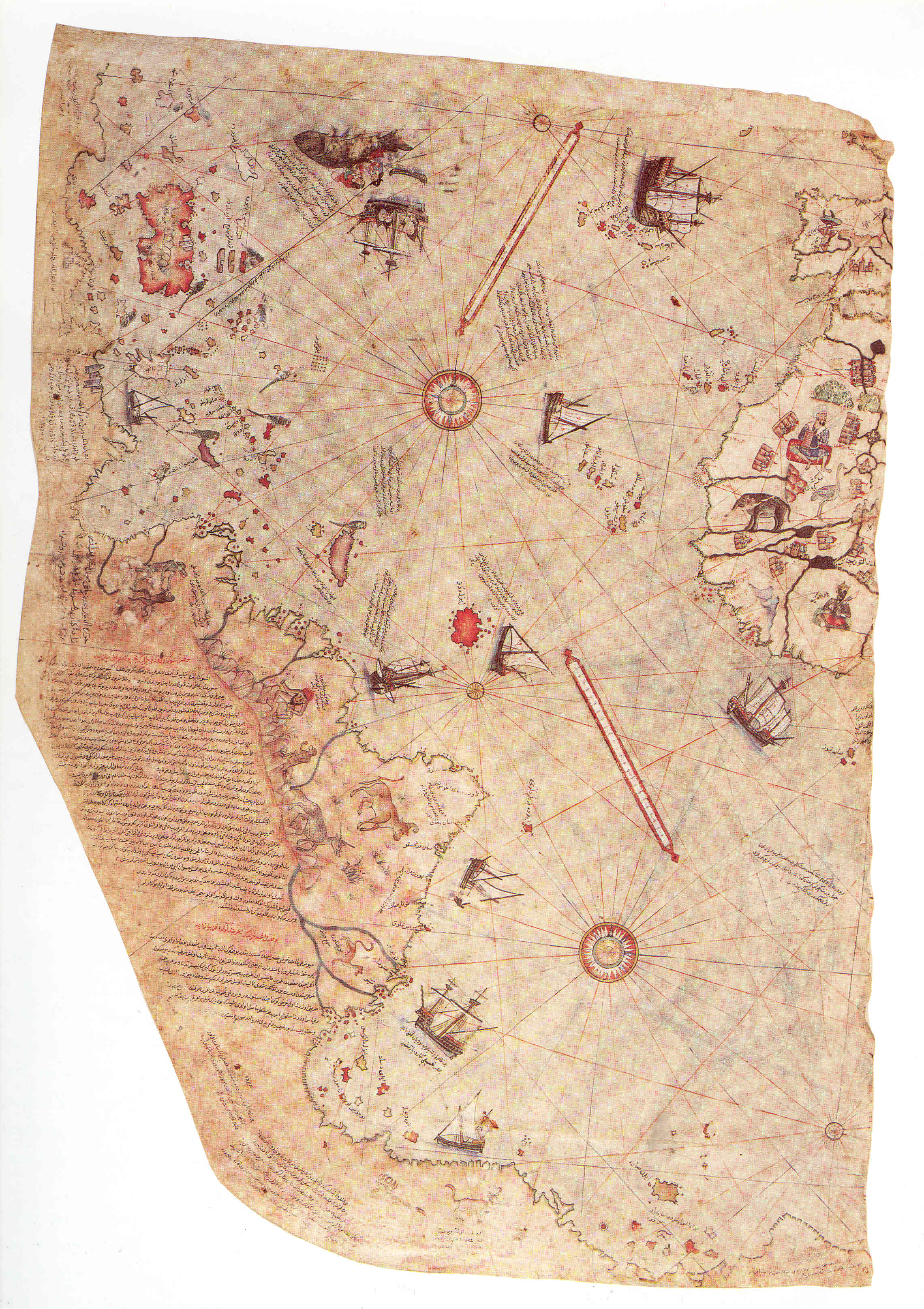
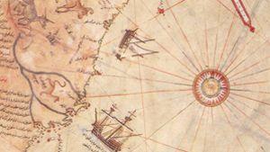
Piri Re’is Map of 1513This is the only fragment that is still in existence today. Notice what appears to be Arab dhows sailing in the Atlantic, along the South American coast, and near Antarctica. An inscription near Antarctica describes night as “two hours” long,” which certainly does suggest Antarctic latitudes.
Also notice that the map clearly shows mountains in the interior of South America, something even the Portuguese had not discovered by 1513. Some have suggested that the animals portrayed in the mountains are llamas, even though they appear to have horns, and amazingly enough, a note says “The gold mines are endless. Did the map makers know of the gold in Peru?
Click for a larger image
As you can see in the picture above, the map contains many inscriptions. Most of the inscriptions tell us which Portuguese maps that particular section was constructed from. These are all typical of the era in which Piri Re’is lived in. The most interesting part of the map, however, is the part that shows Antarctica and South America. Near this section of the map, an inscription (near the bottom left hand side) reads:
“This section shows in what way this map was drawn. In this century there is no map like this map in anyone’s possession. The hand of this poor man has drawn it and now it is constructed. From about twenty charts and Mappae Mundi: these are charts drawn in the days of Alexander, Lord of the Two Horns, which show the inhabited quarter of the world; the Arabs name these charts Jaferiye-from eight Jaferiyes of that kind and one Arabic map of Hind, (India) and from the maps just drawn by four Portuguese … and also from a map drawn by Colombo in the western region I have extracted it. By reducing all these maps to one scale this final form was arrived at. So that the present map is as correct and reliable for the Seven Seas as the map of these our countries is considered correct and reliable by seamen.”
From this we can assume that Piri Re’is constructed the portion of the map showing Antarctica and South America from ancient Arab maps dating from the time of the Ptolomies, as well as additional information gained from the Portuguese of his day, (Columbus and others), who mapped the northern part of South America as well as islands in the Caribbean.
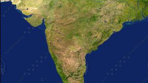
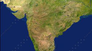
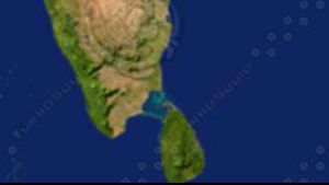
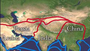
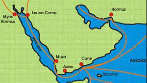
The question that our readers have raised is this: If the southern part of Piri Re’is map of 1513 was based on earlier Arab maps; who were these Arabs who had such navigational technology to sail there and produce maps? And if the original Arab maps were based on an equidistant projection which has its center on the meridian of Alexandria in Egypt, then might this not have Nabataean implications? If the Nabataeans were already sailing to Palk Bay in Sri Lanka to obtain Chinese goods, might they not have sailed farther? If Nabataean entertainers had entered China by 120 - 130 BC then surely they were in a position to sail even farther? It would only make sense that they would use Alexandria as the center of their maps, as Alexandria was the center of learning, as well as the center of Nabataean trade. Under Ptolemy II, (308 - 246 BC) Alexandria played a leading role in arts and science. Throughout the whole Mediterranean world Ptolemy II acquired a reputation for being a generous patron of poets and scholars. Surrounding himself with a host of court poets, such as Callimachus and Theocritus, he expanded the library his father started and financed the Alexandria museum, so that they became the leading research centers of their day. Learning was not confined to philosophy and literature but extended also to include mathematics and natural sciences. The age of Ptolemy II coincided with the apex of Hellenistic civilization. A prudent and enlightened ruler, Ptolemy II found his strength in diplomatic ability and his satisfaction in a very wide scope of learning. Thus it would not be surprising if Ptolemy II funded an expedition to explore and map the eastern world. His father had been with Alexander the Great in India, and so Ptolemy’s curiosity and desire for learning may have led him to finance exploration journeys to the far ends of the earth. His desire for learning corresponds with the exact same time when the Nabataeans supplied the city with many exotic goods from Asia. Thus, it would only seem that if Ptolemy II financed the exploration, that he would have used Nabataean sailors to carry it out. Prof. Charles Hapgood maintained that the source maps for Piri Re’is map were themselves based on earlier maps, compilations of which were made at the Great Library of Alexandria (Egypt). However, there are others who argue that this could not be true, as the traditional Ptolemaic atlas not only omitted the western hemisphere, it did not show anything above 63 degrees north or below about 16 degrees south. There was little reason to do so as long as it was thought that great heat or cold, or the vastness of the ocean, would prevent anyone from traveling beyond these bounds.
But supporters of the Nabataean theory argue that perhaps the Nabataean sailed to Antarctica, and produced maps and records that were all stored in the Great Library of Alexandria where they were lost to the world in the fire of 48 BC. They claim, however, that perhaps one Nabatatean map did survive until 1513, when it was incorporated into Piri Re’is Map. When challenged about the scientific knowledge it would take to produce this kind of map (such as plane geometry and trigonometry) they quote Abu Bakr Ahmad ibn Ali ibn Qais ibn Wahsiyah an-Nabati, who was a physician and botanist around 900 AD. He was not only a great scholar of his day, but perhaps the greatest spokesperson on behalf of his illustrious ancestors, the Nabataeans, to whom he attributed nine-tenths of all scientific knowledge known. His books are known as Al-Filiaheh an-Nabatiyah (904 AD) and As-Sumum wat-Tiyaqat (900 AD). Ibn Wahsiyah claimed that his ancestors, the Nabataeans, were held in low regard by the Arabs of his day, when in fact they were the ones who brought to the Arabs knowledge of mathematics, astronomy, animal husbandry and more. Then to top it off, they point to an acticle in Scientific American, (1900) where archeologists discovered an astoundingly advanced gearing system in a Greek navigational instrument that dated back to 65 B.C. Sadly, this discover was noted, written up, and then filed away and is seldom referred to today by historians.
Unfortunately, none of the very early maps from the classical world, have survived. The maps accompanying Ptolemy’s great work on geography, for example, were totally lost and the maps that are included in his later published books were drawn 1,000 years after he wrote. An early Arab author, moreover, reported that a globe of the world by Ptolemy (the geographer) existed in Cairo in the 14th century. Arabic literature also contains numerous tantalizing mentions of “lost maps.” The 10th century author Ibn Nadim, for example, speaks of a Persian map of the world drawn on silk in colored paints, conceivably a copy of a classical map, but in any case lost to history. But perhaps some day, an early map will be discovered. In 1955, a cartographer named M. Destombes announced the discovery of Ferdinand Magellan’s own chart of his epochal circumnavigation of the world. No one had known it existed, but Destombes found it in the archives of the Istanbul library, very near where Piri Re’is map of 1513 was found.
Did the Nabataeans reach Antarctica and South America? Unfortunately we may never know. This theory contains a lot of speculation, more than academic science would allow. It is also unfortunate that those propagating theories about aliens from outer space and the uncovering Atlantis also point to Piri Re’is map for proof of their theories. However, when we ignore all of the hype and look only at the bare essentials, it does cause us to wonder….
Copyright 2002 CanBooks


Page Discussion
Membership is required to comment. Membership is free of charge and available to everyone over the age of 16. Just click SignUp, or make a comment below. You will need a user name and a password. The system will automatically send a code to your email address. It should arrive in a few minutes. Enter the code, and you are finished.
Members who post adverts or use inappropriate language or make disrespectful comments will have their membership removed and be barred from the site. By becoming a member you agree to our Terms of Use and our Privacy, Cookies & Ad Policies. Remember that we will never, under any circumstances, sell or give your email address or private information to anyone unless required by law. Please keep your comments on topic. Thanks!