Click below to watch the video:
Dan Gibson addresses the question of Macorba and other locations being the city of Mecca on ancient maps.
Transcript
Video #6 This is a general transcript of a Dan Gibson video in the series: Archeology and Islam.
Hello, and welcome to another video in the series Archeology and Islam. My name is Dan Gibson.
In the film, The Sacred City I made a statement that I have searched ancient maps, and never once have I found Mecca mentioned before 800 AD. It is not on ancient maps.
I still stand by that statement, but it did cause a reaction. I have received many emails, and some folk have gone so far as to create videos to refute me. However, back in 2013 I wrote a paper on this very subject.
So in this video we want to explore their claims and I hope I can explain why I still stand with my opinion that Mecca is NOT on any early maps.
All the information I give in this video can be found in the paper: Suggested Solutions for Issues Concerning The Location of Mecca in Ptolemy’s Geography, which I wrote in 2013. You can find this paper on the internet on this website.
First, everyone who has written to me on this point, and every film made so far, to refute me about ancient maps, uses the same information. To date, no one has come forward with a newly discovered map that contains the name Mecca.
Instead, people come forward with the same old maps, and they point to this city or that city and claim that it is really Mecca, but it has a different name. So no one has found a map that has the name Mecca on it.
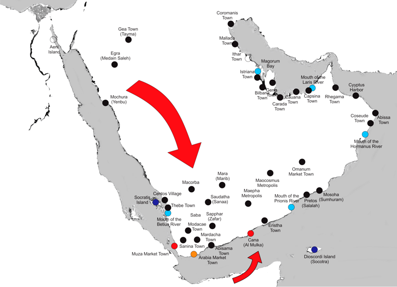
It is always some other name. The most common name is Macorba, but some point to Centos Villa and others point to Thebe and say… “This is Mecca.”
However, they have no other evidence, except that these towns are on old maps, and in the middle of Arabia. Even though they are beside the Betius River, they still claim how this is Mecca, on the shores of a river.
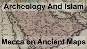
Now there are some misunderstandings about these old maps. Everywhere I go, people assume that they are all different maps. They all look different, and they are drawn by different people at different times; sometimes centuries apart.
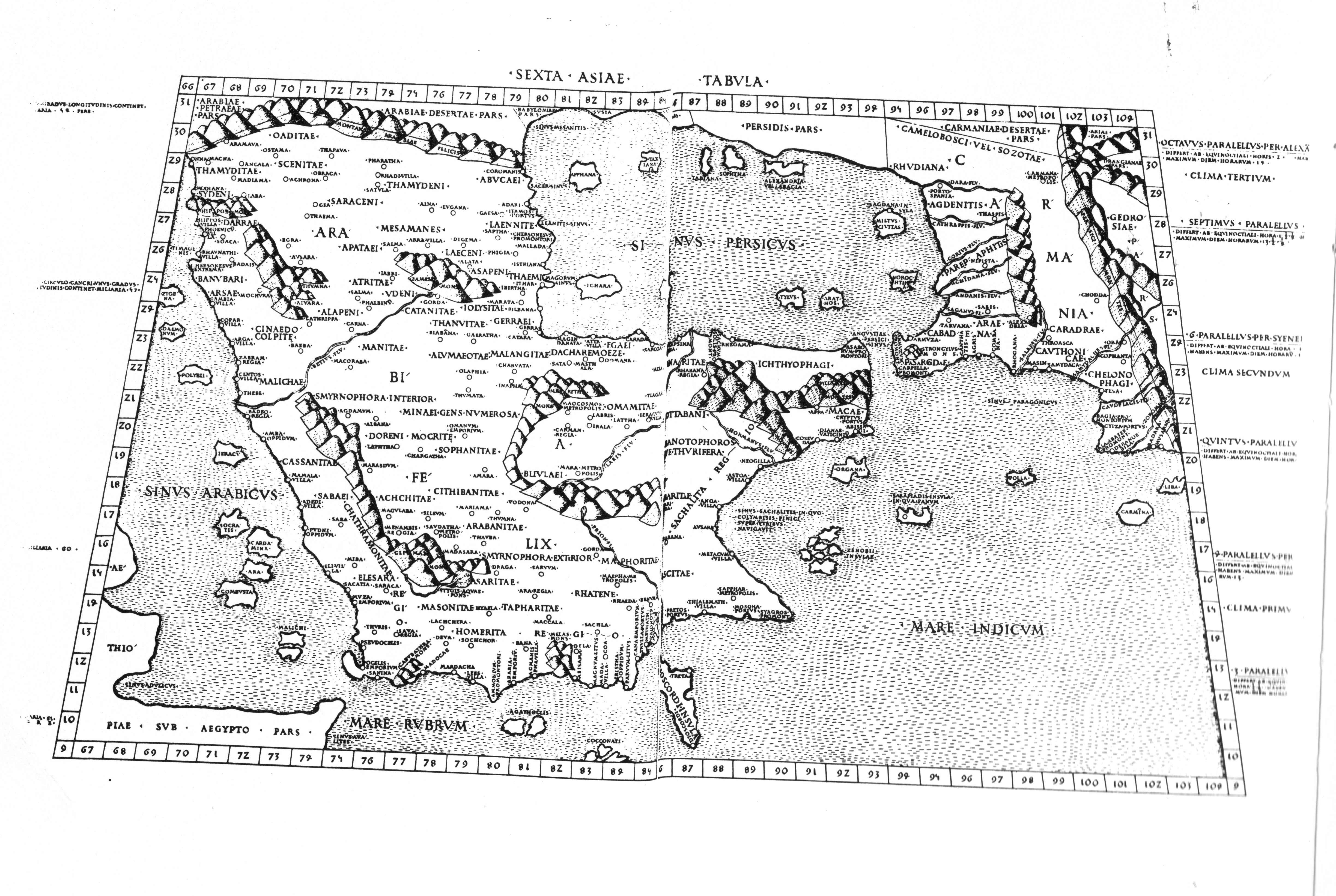
For example, here is a map drawn in 1467, Here is a map drawn in 1478, Here is a map drawn in 1516, And another map from 1595, And here is one from 1720, The list goes on and on.
These maps all look different, but actually, they are all the same. All of them have something in common. All of them mention that they are “after Ptolemy” or labeled “PTOLEMAEUS, Claudius” or just “Claudius” What does this mean?
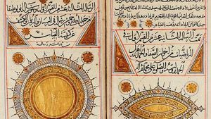
Even though the maps were drawn in the 1400s and 1500s, they are all based on information from Claudius Ptolemy. He was a geographer who lived in Alexandria in around 90-160 CE, about 400 years before Islam. While he drew many maps, his greatest accomplishment was a globe, a round globe on which he noted many places. However, his maps and his globe did not survive. All we have today is his book: The Geography, which lists cities and some features along with his own system of latitude and longitude. The Geography is composed of eight books with the first volume explaining the method behind his system he uses and then volumes 2 - 7 contain lists of locations and their coordinates and then the last volume gives the 26 regions known in his day.
Now around the beginning of the 15th century his works were rediscovered and translated from Greek into Latin, and that sparked the idea of a global coordinate system. That revolutionized European geographical thinking. Starting in 1477 until as late as 1560s people were drawing maps based on Ptolemy and the coordinates he left us from his three dimensional globe. Starting in 1561 Gastaldi and a host of others began to make little corrections to Ptolemy map. And they began to change the map slowly, but all of them still say Based on Ptolemy. Because at that time, more British explores were coming back, and the British began to develop their own system of latitude and longitude that was different from what Ptolemy used.
- Now all of the maps that people use to protest my statement have been drawn using the information that Ptolemy provides for us. Each map-maker drew his own maps but the names and positions all come from Ptolemy and are often labeled Ptolemaeus, Claudius.
- I have also examined maps made with the Arabic system of qiyās, and isba’ and taf’īla and so forth. And they give the measurements in isba. And they are measuring from the north star. Under the Qiyās system the world was divided into 224 isba’ or 224 degrees, not 360 which is what the west uses; we took it from the Babylonians.
- Then there are maps made with the modern system of latitude and longitude. This was developed by the British in 1714 and it’s based on the town of Greenwich in the UK, and it uses 360° degrees around the world. Many books are written on the subject.
So we end up with 3 systems. Three different ways of looking at the world.
- We have Ptolemy’s maps that are based on 81° degrees north and south and 360° degrees east and west (and he drew a map of only 180° degrees)
- We have the Arab maps and they are based on 240° degrees around the world … a complete different system of numbers all the way around the world.
- And then we have our modern system based on 360° degrees all the way around the world. As you can see, it will not be easy to move data back and forth between these systems. You cannot just take Ptolemy’s map and just stick it onto a modern map. You have to look at the coordinates that Ptolemy is giving us.
Today few scholars accept Ptolemy’s coordinates as accurate. The value of his coordinates has been contested by many scholars and a lot of arguing has taken place over the years… lots of academic discussion on these maps.
Now there is a lot of reasons for this: Ptolemy, first of all, he calculated the circumference of the earth as 28,985 kilometers - a massive error - nearly 28 percent wrong. But his circumference was used in Europe for over 400 years. That is one of the problems with the maps we are going to look at. He got his circumference of the world wrong.
He measured also, only from the equator up to the polar circle. He had 81° degrees in that time… from deep in Africa up to the Arctic Circle: a different system of measurement.
And he put longitude and latitude, he started in the Canary Islands as 0 and he went over to 180° degrees in China. That’s the world that he knew about. So all of his calculations are then but since they made the world too small, all of his calculations are wrong.
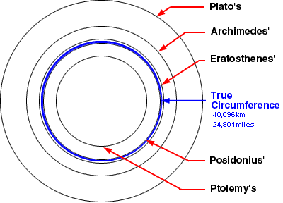
Ptolemy's world was the smallest of the ancient historians.
This was perhaps one of the major reasons why Columbus thought he could sail across the Atlantic Ocean to China because he understood from Ptolemy’s maps that the world was much smaller than it really was. Now since Ptolemy never visited most of the sites he had to rely on merchants and sailors to give him descriptions. Many of the places he mentions were plotted very poorly because he didn’t know the exact location so he rounded most of them to the nearest degree… which is quite a system when you have only 180 from the Canary Islands out to China.
And then he has many mistakes and inventions told to him by merchants and travelers! Rivers in Arabia for example. Ptolemy, who was desperate for information of every place in the world he got his information from whomever he could find and they came… Sometimes the information was misleading, sometimes it was fanciful and sometimes it was just wrong.
Another problem is that many of the names Ptolemy lists are obscured because they are written as the Greeks knew them or heard them, not as they might have been called in their original language. Since the Greeks did not have all the sounds of all the other languages, many sounds were lost. So imagine a Greek sailor hearing an Arab telling him of a place. And that sailor later, some years later meets Ptolemy and he tries to remember what that other sailor told him and he tries to pronounce the city. The chances of getting it right are kind of slim. Another issue with Ptolemy is that he uses a globe but map makers were drawing on a flat surface. Each of the maps produced from Ptolemy’s coordinates looked slightly different because each map maker had a different picture in his mind.
Today it is common for people to simply look at the maps drawn in the 14th and 15th century and imagine which names match modern names, rather than comparing the names, the descriptions and the degrees of Ptolemy’s latitude and longitude and trying to understand what was Ptolemy actually trying to referring to.
Now back in 2012 and In 2013 I spent considerable time working on Ptolemy’s maps. His maps of Felix Arabia. had to examine many other locations with a mathematician and computer programmer, we developed a computerized model and mathematical algorithm that would allow me to translate data from Ptrolemy’s map into a modern latitude and longitude.
Now early in this process we began to understand that Ptolemy’s latitude is quite stable but his longitude coordinates show that he slowly stretched his map out towards the east. So it is not exactly one over the other. He didn’t quite understand how things fit. And so some places become bigger than others. And he divided his descriptions of Arabia then into three separate maps. He is pretty accurate in Arabia Petraea, because Romans traveled there and he could get lots of information.
He also does a fairly decent job on Arabia Felix which is down in Yemen and an important place for trade. But Ptolemy has trouble with Arabia Deserta. He lists only 50 places, compared to over 200 places in the others. So when we look at this, we have to begin to look at what can we use to judge? How can we tell things? One of the secrets is to look at the Rivers in Arabia.
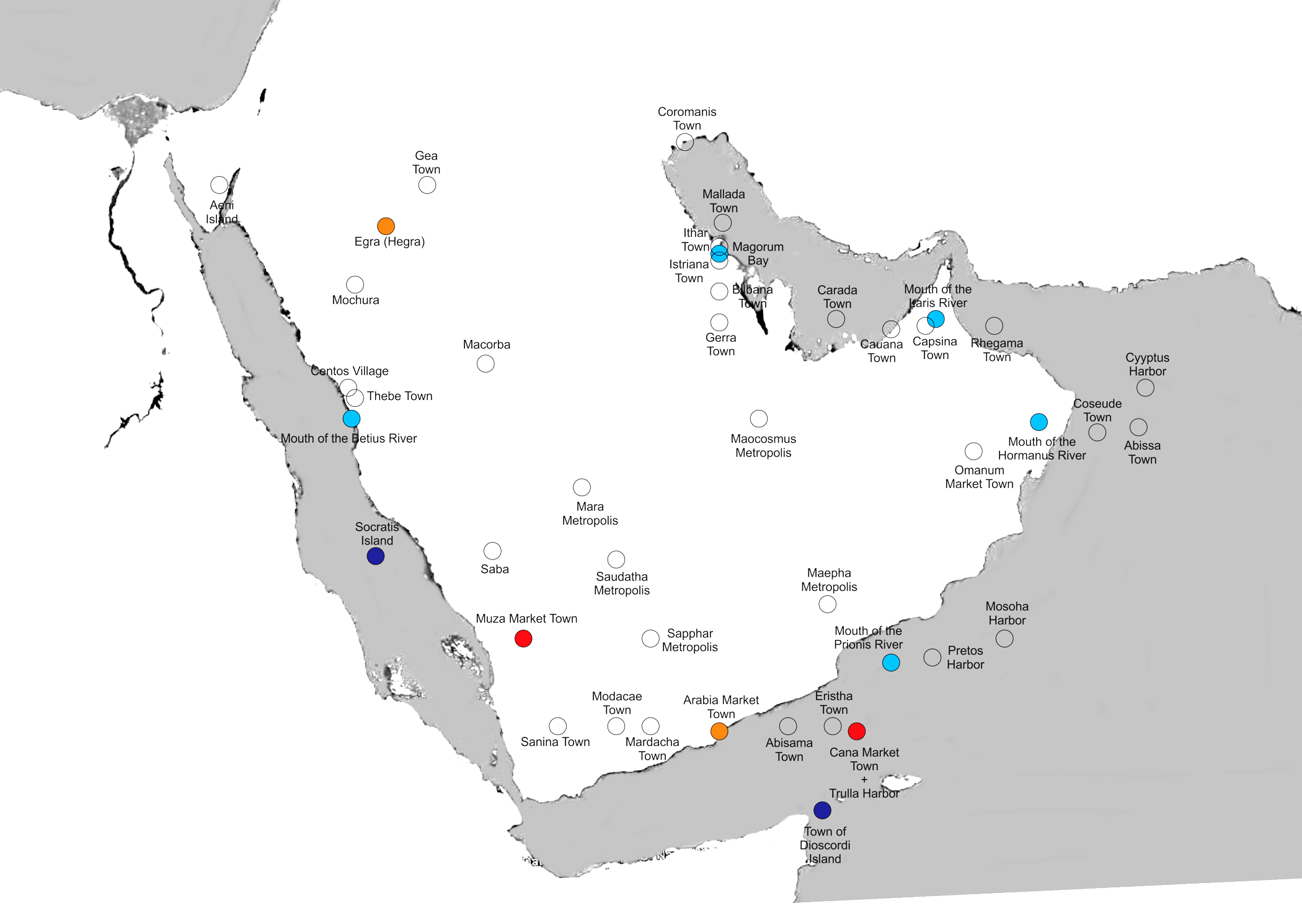
And that is one of the problems in trying to equate Mecca with Macoraba, Centos or Thebe is there is this Betius River which Ptolemy tells us flows through this section.
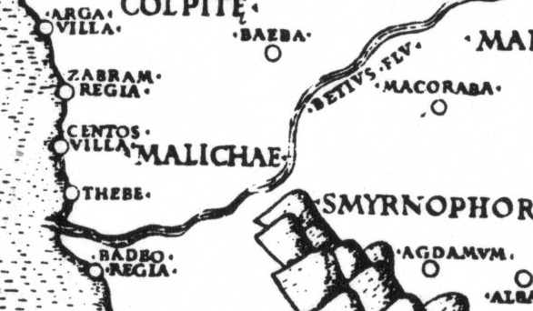
Macoraba on the Betius River flowing to Thebe .on the coast
It is a problem for modern geographers as well as there are no active river systems anywhere in Arabian today.
But Ptolemy clearly marks the mouth of this river on the Arabian coast, just south of Thebe as well as 2 rivers running into the Indian Ocean and one running into the Persian Gulf. Now the existence of these rivers have cast some doubt on the accuracy of Ptolemy’s maps.
But as I have traveled through all of Arabia, I have begun to realize these rivers are key to understanding what he is speaking about.
They are very important. Over time the names of cities and villages change and they become ruins and they crumble and are lost, but river courses, they may change a bit but they are still there. There is evidence of where the river was flowing before.
So I believe the rivers give us a bridge between Ptolemy’s book and the globe we know today.
On the map you will see that the Betius River is clearly marked just south of Centos and Thebe. Ptolemy clearly marks these places as coastal locations, not inland as some have imagined. He has separate lists and he provides the list of names of places on the coast and he provides a list of names inland. Macoraba is listed as inland while Centos and Thebe are clearly listed as coastal locations.
If we are going to locate these cities, we must understand where the Betius River is located. We get the Betius River right and that will help us get the rest of the map right.
Now the earliest description we have for this coastline is from the Periplus Maris Erythraei which is an ancient book that was written. It makes no reference to a river or ports in central Arabian along the coast. This written during the first century CE shortly before Ptolemy made his map, and no rivers are mentioned along that coast.
The Betius River appears on all of the maps after Ptolemy but using modern maps we realized that the river is not in the right place. And so what are we going to do?
As we will demonstrate, Ptolemy imagined Arabia Felix to be larger than it was, and so he located it too far north. And most of it is down in the south.
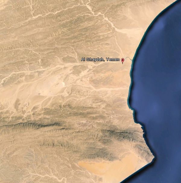
The Betius River will help us as we look at it, because it comes out of the mountains, it come out from Yemen down to Al Luhayyah on the Red Sea coast. We find this. Here, it looks like what he is drawing. We can now see the mountains and the coast and we can see the islands that correspond to Ptolemy’s maps just off of it.
The Tihama is the broad flat stretch of sand that separates the mountains of Arabia from the sea coast. Wadi Mawr flows through a clearly identified river bed across this sandy area and empties into the Red Sea near the ancient town of Al Luhayyah.
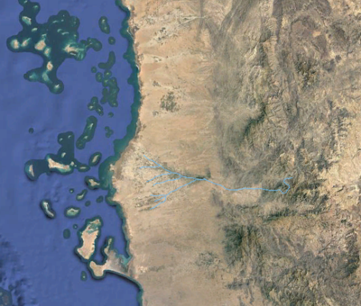
Ancient river course highlighted with blue
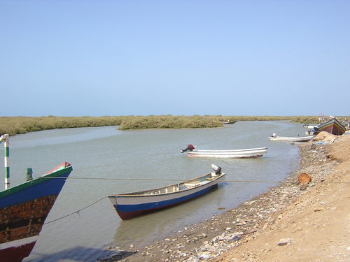
Just below the river and in the interior Ptolemy tells us, is the region of Sabaei or Saba and the region which grew Myrrh. This helps us confirm that the Betius River is Wadi Mawr, as it is located just north of the Saba region. I personally traveled all through this area in the 1980s. The area is very flat, and the wadi flows from the mountains into the Red Sea. In the photo you can see why sailors might have imagined a river was flowing out at this point, because it was a dry wadi bed. When it rains the water does come down and flow into the Red Sea.
Betius
This clearly helps us understand why he labeled this the Islands of Jazan off the coast there, and the Wadi comes down and so forth… and the Ptolemy maps point … and what we are looking there I believe is Al Luhayyah. But that is only one river.
So we need to move on to the next river. And Ptolemy identifies the mouth of the next river, he calls it the Prionis River and it is on the Yemeni coast. Now here is Wadi Dhahawn Notice how it appears as a river on the coast, right near this town and you can see how sailors going by would look up and see there this flows in and think there is a river flowing there.
Prionis
Ptolemy lists the Hormanus River as flowing into the Indian Ocean. Today Wadi Bani Khalid flows down, ah, this is in Oman, It is near Al Jumaylah and it flows down into the ocean. Dry most of the year. Ptolemy I believe identified that as a river.
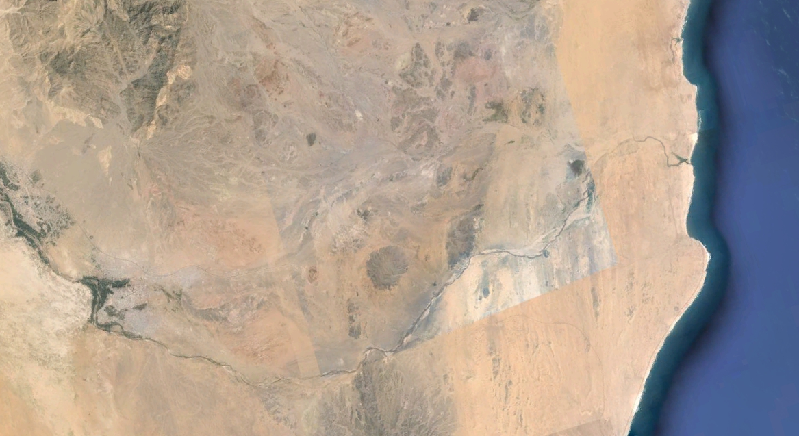
Hormanus
The last river is what he calls the Laris River It is on the north side of Arabia, It flows into the Persian Gulf to the north. And today that corresponds I believe with what is known as the creek in Dubai, The city of Dubai. If you look down on the city of Dubai you can clearly see the creek and where the ancient river flowed.
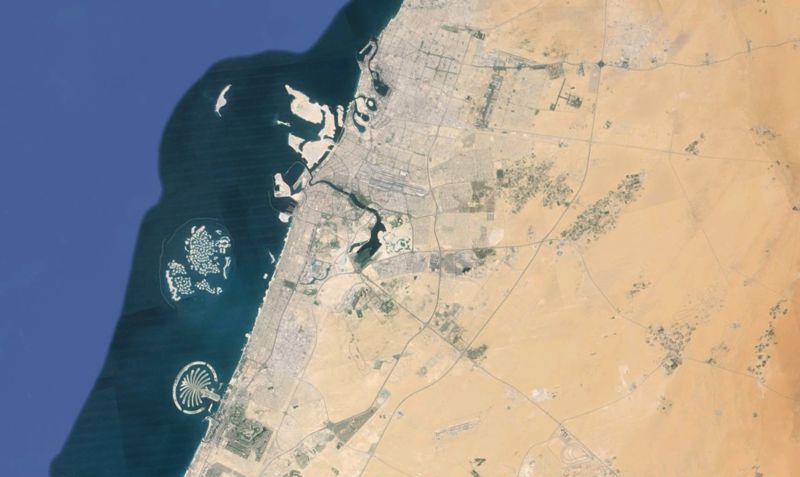
Laris
So this gives us four rivers that will help us line up Ptolemy’s map with the actual map and the satellite photos that we have. Now there’s a number of city locations on Ptolemy’s map which are well known today. He correctly identifies the Yemeni ports of Muza, and Aden and Cane and so forth. And so we can identify those. When we attempted to overlay though these maps over a modern map things don’t fit. Notice that there are cities in the ocean. Very little don’t fits. So we are going to have to manipulate a little bit to see what he has drawn.
By lining up Hegra, it was obvious that Ptolemy's coordinates needed adjusting.
The solution to this was to use the rivers and line them up. So when we move the map so we get the rivers right.
Stretch south with a slight twist.
In order to do this we anchored Ptolemy’s map using Hegra in the north. Remember we talked about Hegra in the last video. And so we recognized that Mochura in the north as also Yenbu so we had two points we could anchor in the north of the map.
Then we began to move the map around, anchoring this, and we could do this with the computer, and manipulate it until we got all four rivers fit.
When we did this, many of the interior locations suddenly became apparent.
• Ptolomey’s Centros Village becomes Jazan • And Thebe Town became Al Luhayyah • Macorba becomes Al-Mahabishah • Mara then becomes Ma’rib, which is where the great dam was then, that is important in Islamic history. • So Saudatha became Sana’a • Sapphar became Zafar, modern day Zafar, • On the Indian Ocean coast Petros became Salalah • Mosoha became Sumhuram
And as we adjusted this though, according to river locations, the city coordinates started to make more sense as they began to line up.
Obviously Ptolemy grossly underestimated the size of the Nafud Desert in Saudi Arabia and he allowed the locations of his map to drift north. Because he made… because Yemen was important it became bigger than it was, and in his mind the deserts in Saudi Arabia were smaller.
From this corrected map we can easily discern what Ptolemy intended, and we can also be quite safe to concluding that Mecca and Medina did not appear on any map based on Ptolemy.
This would be in keeping with the archeological records that shows that Medina was not settled as a significant urban area until the breaking of the Ma’rib Dam around 570 CE and that Mecca in Saudi Arabia was not settled as a city until after 700 CE.
If you want more information please visit the website on the screen and download the paper: Suggested Solutions for Issues Concerning The Location of Mecca in Ptolemy’s Geography.
You can see Ptolemy’s lists. You can see all of his coordinates. You can see the maps and the pictures of what we did. And you can check out how we viewed Ptolemy’s maps.
I am Dan Gibson, and this has been another edition in the series of: Archeology and Islam.
Bibliography
Agius, Dionisius A., Seafaring in the Arabian Gulf and Oman: People of the Dhow, Routledge, 2009 al Haduri , Shaikh Nasr bin ‘Ali, Kitāb ma’din al-asrār fi ‘ilm al-biḥār (The Mine of Secrets in the Science of the Seas, handwritten manuscript
Casson, Lionel, The Periplus Maris Erythraei: Text with Introduction, Translation, and Commentary, Princeton University Press, 1989
Forester, Charles, The historical geography of Arabia, Volume 1, Duncan and Malcolm, MDCCCXLIV, Introduction, page LX-LXII
Gibson, Dan, Qur’anic Geography, ISP, 2010
Lennart Berggren J., Jones, A., Ptolemy’s Geography. N. Jersey, 2000
Stevenson, Edward Luther, (translator) The Geography, by Claudius Ptolemy, English edition, New York, 1932
Tibbetts, G.R., Arabia in Early Maps, Falcon, Oleander, 1978
Click on the map to see a larger version
Page Discussion
Membership is required to comment. Membership is free of charge and available to everyone over the age of 16. Just click SignUp, or make a comment below. You will need a user name and a password. The system will automatically send a code to your email address. It should arrive in a few minutes. Enter the code, and you are finished.
Members who post adverts or use inappropriate language or make disrespectful comments will have their membership removed and be barred from the site. By becoming a member you agree to our Terms of Use and our Privacy, Cookies & Ad Policies. Remember that we will never, under any circumstances, sell or give your email address or private information to anyone unless required by law. Please keep your comments on topic. Thanks!