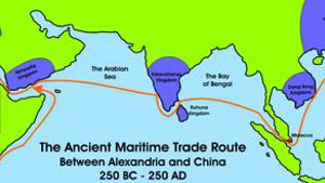
250 BC - 250 AD
During the period between 250 BC and 250 AD, a maritime sea route existed between Alexandra in Northern Africa and China. As trade took place along this route, a number of kingdoms rose to power, flush with finances from trade. These kingdoms all came into being around the same time, and all waned around the same time.
Trade on the Red Sea was in the hands of merchants based out of Alexandria. Nabataeans moved trade from Southern Arabia to their port of Leuce Come by boat, and then overland to Alexandria. “Arab” merchants also brought Indian and Asian goods to the ports on the Egyptian side of the Red Sea. For a time it may have been Indian ships that brought the good to Southern Arabia, as Diodorus tells us of the ‘prosperous islands near Eudaemon Arabia which were visited by sailors from every port of the world, and especially from Potana, the city which Alexander the Great founded on the Indus river.’ (Diodorus. 3.47.9.)
Another description of this situation is found in a text known as ‘The Periplus of the Erythraean Sea’ by an unknown author. Many have assumed he was a Greek living in Alexandria, but he may have just as well have been an Arab merchant with a Greek name living in Alexandria. In it we read that ‘Eudaemon Arabia (Aden) was once a fully-fledged city, when vessels from India did not go to Egypt and those of Egypt did not dare sail to places further on, but came only this far.’ (L. Casson, ed. The Periplus Maris Erythraei (Princeton 1989) 26., lines 26-32) Any attempts by Alexandrian ships to sail beyond Aden were strongly discouraged; if they did sail, it was by laboriously hugging the coasts and in the words of Periplus, ‘sailing round the bays’.
This was the situation until Roman financiers entered the Alexandrian money market towards the middle of the 2nd century BC. The ensuing rise of demand for oriental and southern goods in the Mediterranean markets whetted the appetite of Arab merchants based in Alexandria to increase their share in the north-south trade. They realized that they needed to sail directly across the Indian Ocean to the rich Indian market and bring good back to Egypt, without the involvement of Indian merchants. Ptolemy VIII, friend of Rome, as was his wife after him, demonstrated personal interest and involvement in the project which indicated the great hopes all parties in Alexandria attached to the success of the venture. While it is not known who made the first direct voyage to India, very soon a new important office was created for the first time in the Egyptian administration. It was know as the ‘commander of the Red and Indian Seas,’ and came into being under Ptolemy XII, nicknamed Auletes (80-51 BC). (Sammelbuch, 8036, Coptos (variously dated 110⁄109 BC or 74⁄3 BC; and no. 2264 (78 BC); Inscriptions Philae, 52 (62 BC) The creation of such an office implies that the perhaps at this time there was a marked increase in the regular commercial transactions with India.
It is also perhaps not entirely irrelevant that in 55 BC, the Senate decided to send Gabinius at the head of a Roman army to restore Auletes (Ptolemy XII) to his throne and to remain in Alexandria for the protection of the king against possible future revolts. (Caesar, BC. 3. 110). We can easily detect behind this drastic step, considerable Roman assets at risk in the case of sudden undesirable internal changes in Alexandria.
This should warn us against accepting at face value Strabo’s often quoted remark that it was only under ‘the diligent Roman administration that Egypt’s commerce with India and Troglodyte was increased to so great an extent. In earlier times, not so many as twenty vessels would have dared to traverse the Red Sea far enough to get a peep outside the straits (Bab-el-Mandab), but at the present time, even large fleets are dispatched as far as India and the extremities of Aethiopia, from which the most valuable cargoes are brought to Egypt and thence sent forth again to other regions.’ (Strabo, 17.1.13.) This is clearly an overstatement, intended as a compliment to the new Roman administration, considering that Aelius Gallus, the prefect of Egypt, was Strabo’s personal friend at whose house he stayed as a guest for five years (25-20 BC). Strabo’s statement stands in sharp contrast to the earlier data of the above mentioned inscriptions and to the more matter-of-fact statement of the later author of the Periplus (c. 40 AD), who rightly perceived that the great change in the modes of navigation and the vast expansion of trade were the direct result of the discovery of the Monsoon winds, at least half a century before Augustus conquered Egypt. Strabo himself witnessed the flourishing state of Alexandria only five years after the Roman conquest, and very shrewdly observed the active trade that went through its several harbors. He says, ‘Among the happy advantages of the city, the greatest is the fact that this is the only place in all Egypt which is by nature well situated with reference to both things, both to commerce by sea, on account of the good harbors, and to commerce by land, because the river easily conveys and brings together everything into a place so situated, the greatest emporium in the inhabited world.’
Soon after the annexation of Egypt, Emperor Augustus (Rome 63 BC - Nole 14 AD) in 26 BC commissioned his prefect in Egypt, Aelius Gallus, to invade southern Arabia by land. (Strabo, 16.4.23-4.) This land onslaught caused considerable damage to the Sabaeans as far as Marib, and allowed the Himyarites, close friends of the Nabataeans to soon take control of most of Southern Arabia. Some writers have thought that around AD 1 Augustus launched another devastating attack - this time by sea - which resulted, in the words of Periplus,‘in sacking Eudaemon Arabia’ which declined into, ‘a mere village after having been a fully fledged city (polis)’. (Periplus, 26; Pliny, H.N. 6.32, 160 & 12.30,55; Also cf. H. MacAdam, ‘Strabo, Pliny and Ptolemy of Alexandria’, in: Arabie Pre-Islamique (Strasbourg 1989) 289-320.) Now that Eudaemon Arabia (Aden) was out of action, merchants from Alexandria experienced unrivalled dominance of the sea route to India.
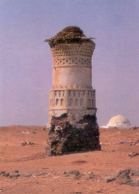
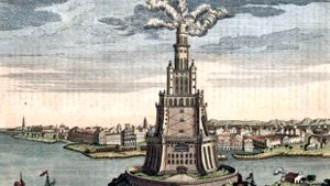
The old lighthouse in Al Mokha port (Yemen)
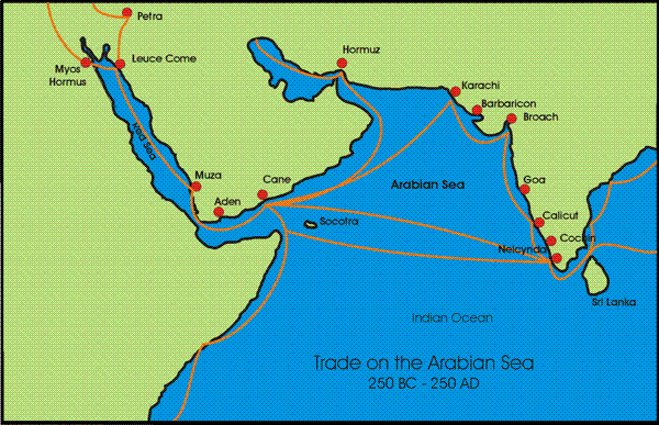
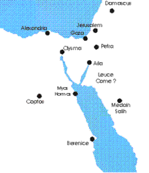
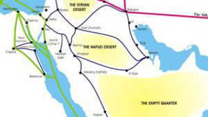
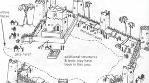
LEUCE COME
The Nabataean Port City in Arabia
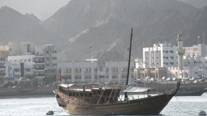
The Nabataeans maintained two ports that we know about. The first was Aila at the northern end of the Gulf of Aqaba. This port was used almost exclusively by Arab boats as the Gulf of Aqaba was known for its foul winds, making it a very difficult port for the square rigged European boats. (Casson, Periplus page 144) Arab dhows however, could sail much closer to the wind, and could better utilize Aila, providing it with goods from southern Arabia. It is interesting to note that the Romans ended their road at Aila, rather than continuing farther down the Arabian coast.
The Nabataeans also maintained a port on the Red Sea known as Leuce Come (meaning white village.) This harbor later served as a port of trade for European ships as well as the smaller Arab dhows that would come loaded with freight from Arabia. (Periplus 19) The Nabataeans/Romans maintained a customs office at Leuce Come as well as a centurion and a detachment of soldiers. The usual customs on luxury goods was 25%. This port may have been located at the modern village of Khuraybah. (See Where was Leuce Come?) From Leuce Come a caravan route wound it’s way north to Petra. (Strabo 16.781)
To date, no one has established the exact location of Leuce Come. The Periplus describes briefly describes it, mentioning that there was a fort there where taxes were collected. It also mentions that small ships used this port. Perhaps this was due to coral reefs. Strabo mentions Leuce Come in his narration about the Roman attempt to take Arabia. He tells how the Romans had trouble navigating their ships through the coral reefs to land.. “After enduring great hardships and distress, he arrived on the fifteenth day at Leuce-Come, a large mart in the territory of the Nabataeans, with the loss of many of his vessels, some with all their crews, in consequence of the difficulty of the navigation, but by no opposition from an enemy. These misfortunes were occasioned by the perfidy of Syllaeus, who insisted that there was no road for an army by land to Leuce-Come, to which and from which place the camel traders travel with ease and in safety from Selah, and back to Selah, with so large a body of men and camels as to differ in no respect from an army.” XVI.iv.24
The fort and taxation center at Leuce-Come demonstrates to us that foreign caravans would frequent the place, and that they would be taxed. Nabataean caravans and boats were part of internal trade, and may not have been taxed in the same way. Interestingly enough, to date this is the only reference we have of the Nabataeans taxing goods passing through their land.
For many centuries, historians have wondered about the exact location of the famed Nabataean city of Leuce Come. Recently, a Nabataea.net researcher began work on locating this missing city. Using ancient historical records and modern satellite photos he assembled much of the evidence available today, but no satisfactory port was located along the Saudi Coast. Then, looking once more at the evidence, he believes he may have solved this centuries old riddle. Check out a report of this research on the following page: A Possible Solution for Leuce-Come.
A POSSIBLE SOLUTION FOR LEUCE COME?
Dan Gibson, 2004
For many years historians and archeologists have wondered about the location of the Nabataean port city of Leuce Come, (meaning, “white village”). This village is mentioned in several ancient writings, such as the Periplus of the Eruthraean Sea, Strabo’s history, etc. The most serious guess at the location of Leuce Come comes from the famous naval historian, Lionel Casson who calculated the location of Leuce Come to be the port of Myos Hormos. He assumed that the Myos Harbor( Mussel Harbor), was located at Abu Sha’r. He defends this opinion on page 96 of his translation of the Perilpus Maris Eruthraei. From this location on the west shore of the Gulf of Suez he followed the writers description and came to the conclusion that Leuce Come was located in the vicinity of Aynunah on the shores of Saudi Arabia (page 143). Casson goes on to mention some of the other educated guesses that have been made concerning the location of Leuce Come, such as Haura and Yanbu further south on the Saudi Arabian coast. (T*he Perilpus Maris Eruthraei, Text with Introduction, Translation and Commentar*y, Lionel Casson, Princeton University Press, 1989)
These educated guesses were all based on scholarly study and opinion. However, since their writing several important archeological discoveries have been made. The location of Myos Hormos has now been positively fixed at Quseir al-Qadim far to the south of Abu Sha’r. The ruins at Quseir al-Qadim were the subject of exploratory excavations between 1978 and 1982 (*Whitcomb and Johnson 1979; 1982a,*b), when it was thought to be the relatively minor Roman port of Leucos Limen, a view apparently confirmed by a somewhat enigmatic ostracon (Bagnall 1986), and held by Casson. Some scholars have voiced the opinion that Leucos Limen might even been Leuce Come.
Then in 1994, ostraca from the French excavations at Zerqa on the road between Quseir and Qift, showed that beyond doubt, the port at the end of the road was indeed called Myos Hormos (Bülow-Jacobsen, Cuvigny and Fournet 1994). Archeological work done in 1999 demonstrated that the road ended at Quseir al-Qadim (rather than Quseir) and amongst the few ostraca the archeologists recovered was one bearing the name ‘Myos Hormos’. Suddenly historians realized that Quseir al-Qadim was not a minor trading station, but rather Myos Hormos, the renowned ancient port that traded with India and beyond.
For more information visit the website: http://www.arch.soton.ac.uk/Research/Quseir
The positive identification of Myos Hormos has changed all of the previous suggestions for the location of Leuce Come. Myos Hormos was not located in the Gulf of Suez, but on the Red Sea itself. This new location shed a very interesting light of how we now view the words in the Periplus of the Eruthraean Sea. Using the new location of Myos Hormos, we can set out to discover where Leuce Come was located. What we discovered in our search surprised all of us.
The Search
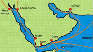
We started our search for Leuce Come using the description of it’s location as found in the Periplus of the Eruthraean Sea: (19).
“Now to the left of Berenice, sailing for two or three days from Mussel Harbor eastward across the adjacent gulf (across the Red Sea or is it a gulf on the Egypt side?), there is another harbor and fortified place, which is called White Village (Leuce Come), from which there is a road to Petra, which is subject to Malichas, King of the Nabataeans.”
“It holds the position of a market town for the small vessels sent there from (South) Arabia; and so a centurion is stationed there as a collector of one-fourth of the merchandise imported, with an armed force, as a garrison.”
To locate this missing city we must determine if the “White Village” was south or north of Berenice, and if it was on the Egypt or Arabian side of the Red Sea.
North or South
From the quote above, the presence of a road linking the White Village with Petra is undeniable. It would make little sense to describe a port SOUTH of Berenice on the Egypt side that had a road linking to Petra (which is far NORTH of Berenice.) So the answer is simply that the White Village must have been located across the Red Sea. The problem is that there are no ports that fit this description, nor or there any roads that fit the description.
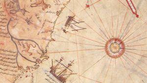
The other important term is the use of the word “to the left.” This term can be understood from the opening sentence of the Periplus: “first comes Egypt’s port of Myos Hormos, and beyond it, after a sail of 1800 stades to the right, Berenice. The ports of both are bays on the Red Sea on the edge of Egypt.”
So the writer is imagining himself standing on the shores of Egypt (he was writing from Alexandria). He locates Myos Hormos and Berenice for us, and tells us that Berenice is to the right of Myos Hormos. This would indicate that right means “south east.”
Now a few paragraphs later he tells us that the “White Village” is to the “LEFT” of Berenice. He does not give the distance in stades, but rather in runs.
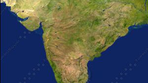
At this point his directions seem a little confused, but I would like to point out that they are quite clear if you know what he is talking about. First of all, we are talking NORTH of Berenice. Then he adds the sentence: “after a voyage of two or three runs eastward from Myos Hormos past the gulf lying alongside.”
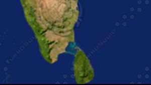
Look at the map above. He points us NORTH of Berenice, the main port on the Red Sea. He then takes us to the smaller port of Myos Hormos. So our journey starts in the south and moves north. The writer then tells us to travel eastward from Myos Hormos for two or three runs, past the gulf that lies along side of Myos Hormos. Given the now positive location of Myos Hormos, and the northward course of the writer’s directions, there is only one conclusion that can be reached.
North of Myos Hormos the Red Sea splits into TWO branches. The writer tells us to take the EAST branch and go north for two or three runs. He doesn’t tell us where to find the port, because we will run into it at the end of the “bay.” Today this place is known as Aqaba, or in ancient times Aila.
It would make no sense for the writer to start us in Berenice, take us NORTH to Myos Hormos, and the SOUTH to some port on the Saudi side of the Red Sea. Rather the writer starts us in Berenice, takes us north to Myos Hormos, and then expects us to continue traveling north, (in the eastern gulf or bay) until we reach Leuce Come. (Aila)
Alia was a place built of white sand structures. Excavations are currently taking place, but the Nabataean port has been mostly destroyed. It did, however, contain a lot of mud buildings. The Periplus informs us that the “White Village” had a road attaching it to Petra. This is very true. The Romans built the Via Traiana overtop of the existing road that was known in ancient times as “The King’s Highway.” This road linked Aila with Petra and north to Damascus. It fits the description of the Periplus perfectly. There WAS a fort in Aila and the city was definitely under the control of Malichus, the king of the Nabataeans.
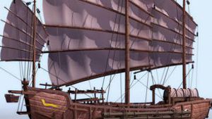
The Periplus tells us that this port was used by small craft (there is no deep harbor at Alia proper), and that it was loaded with freight from Arabia. (See “Who were the Ancient Arab Traders?) It is also interesting to note that the Periplus, which was written to describe “Trade on the Red Sea” does not mention Aila at all. This obvious oversight can now be understood by identifying the “White Village” with the known port of “Aila.”
Farther South
The Periplus then tells us that after this harbour, (White Village) extending “far” down the Red Sea, there are a variety tribes, with some huts along the coast, and they are pirates. It then adds that to set a course along the coast of Arabia is altogether risky, since the region with its lack of harbors offers poor anchorage, is foul with rocky stretches, and cannot be approached because of cliffs. This is why it is important for sailors to sail to the “Burnt Island” before approaching the coast. Several historians have suggested that the “burnt island” is Jabal atTa’ir, which has a nearly dead volcano. (Casson, Muller, Schoff) Then sailing down this coast, there is on the left hand shore, the port of Muza (paraphrased from The Perilpus Maris Eruthraei 20 - 21.)
This sounds like a perfect description of the Saudi coast, looking south from Aila. That is why we cannot find the Leuce-Come along that barren coast. It never was there.
Other Considerations: Strabo
There are two other consideration that must be taken into our calculations. Stabo relates to us the account of the attempted Roman invasion of Arabia. The Romans built boats on the Egyptian side and sailed them to Leuce-Come.
“After enduring great hardships and distress, he arrived on the fifteenth day at Leuce-Come, a large mart in the territory of the Nabataeans, with the loss of many of his vessels, some with all their crews, in consequence of the difficulty of the navigation, but by no opposition from an enemy. These misfortunes were occasioned by the perfidy of Syllaeus, who insisted that there was no road for an army by land to Leuce-Come, to which and from which place the camel traders travel with ease and in safety from Selah, and back to Selah, with so large a body of men and camels as to differ in no respect from an army.” XVI.iv.24
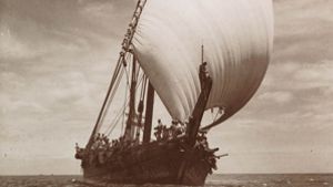
Notice that they endured great hardships and distress in a “fifteen day journey” to Leuce Come. They lost many vessels along the way because of the difficulty of navigation. This has always puzzled me. To sail ACROSS the Red Sea is quite easy. To sail NORTH to Aila however, would have been a very tricky job for Roman boats with square ‘lug sails.’ This may be an indicator that the Nabataeans were using ‘lateen’ sails by this time allowing them to tack in the wind. Most of the year the north-eastern arm of the Red Sea (Gulf of Aqaba) is plagued with winds from the north west, making the journey up the sea almost impossible, unless you had a triangular sail and knew how to tack. The Roman boats were not capable of this.
By locating Leuce-Come as Aila, this passage of Strabo now becomes more understandable. The Romans would have had to sail through the rocky entrance to the Gulf of Aqaba and northward along the rocky coasts where the Roman boats could easily have fouled.


Page Discussion
Membership is required to comment. Membership is free of charge and available to everyone over the age of 16. Just click SignUp, or make a comment below. You will need a user name and a password. The system will automatically send a code to your email address. It should arrive in a few minutes. Enter the code, and you are finished.
Members who post adverts or use inappropriate language or make disrespectful comments will have their membership removed and be barred from the site. By becoming a member you agree to our Terms of Use and our Privacy, Cookies & Ad Policies. Remember that we will never, under any circumstances, sell or give your email address or private information to anyone unless required by law. Please keep your comments on topic. Thanks!