Traditionally the Nabataeans have been known for their role in the incense trade. Frankincense and myrrh, the main components of the incense trade, were obtained from trees located in the southern part of Arabia. (Later, incense was also obtained from East Africa.) The Nabataeans, however, did not farm the trees themselves but rather, purchased the prepared incense from the local people of southern Arabia. As the incense trade grew, the peoples of southern Arabia had the finances to build kingdoms of their own.
Over the centuries, as money entered southern Arabia, these small kingdoms grew and waged war on each other as they struggled to monopolize incense production. Along with this, the port cities of southern Arabia were used by Arab traders for journeys to India and other Asian ports. These traders brought back spices and other goods that augmented the Southern Arabian kingdom’s income from incense.
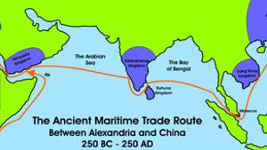
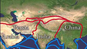
Spices and textiles arrived by ship from India, silk from China and gold and ostrich feathers from Ethiopia. These goods were then packed off by boat and camel caravan to Egypt, Persia, Nabataea, and even to Palmyra in Syria. From these centers, the goods made their way to the civilizations on the Mediterranean.
As the Nabataeans grew in economic power, they gained greater control over the incense trade. Eventually they dominated the shipping on the Red Sea, and through their use of diplomacy and military strength they dominated the caravan routes in Arabia. This made them the exclusive customers of the kingdoms of Southern Arabia, and thus it was vital that they maintain excellent diplomatic relations with these kingdoms and in some cases the Nabataeans even interfered in how these kingdoms were ruled.
In order for the Nabataeans to maintain premium profits, they had to keep their customers: Egypt, Greece, and Rome, from contacting their sources: the kingdoms of the Himyarites and Sabaeans in southern Arabia, as well as their suppliers in India, Ceylon and China. As long as they kept their sources a secret, or at least shrouded by stories and legends, they could incur maximum profits. If they paid the kingdoms of southern Arabia too much, then these kingdoms would grow in size and power, and would eventually start selling directly to the kingdoms on the Mediterranean. If they paid too little, these same kingdoms might one day hear of the exorbitant prices that the Nabataeans were obtaining for their products in Europe, and cut them out of their role as middlemen.
As a result, the Nabataeans played a very careful role, raking in tremendous profits while being very secretive about their trade and trade practices.
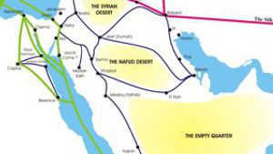
The famed frankincense route was one of the most ancient international trade routes leading from Southern Arabia to Gaza in Palestine. It ran along an inland trail, roughly parallel to the Red Sea and covering a total distance of almost 3,400 km. While production of frankincense was in the hands of the South Arabians, trade was in the hands of the Nabataeans, and both the consumer and the producers were at the mercy of the middlemen. There was not a temple or wealthy home in Babylon, Egypt, Greece, Jerusalem, or Rome which did not require these precious resins to please their gods. Everyone, it seemed, was prepared to pay whatever it took, in order to obtain this precious commodity. Thus, it was vital that the Nabataeans not only have good relationships with these south Arabian kingdoms, it was vital that they remotely guide and influence these kingdoms without seeming to meddle directly in their politics.
Today, archeologists are just beginning to fit together the pieces that are required to give us a basic understanding of the peoples and kingdoms of southern Arabia. This is a very difficult task, however, because while they can read the writings of these people, few things link them to events mentioned in other civilizations. The Nabataeans were their principle link to the outside world, and the Nabataeans did an excellent job in keeping them as isolated as possible.
Early History of Southern Arabia
Prehistoric times in the south of Arabia remain largely un-researched, but more and more Stone Age sites are coming to light. For example, in Yemen, there is a field of 19 stones, each about 6 feet tall, arranged in a circle with a circumference of about 250 feet. Beyond the ring are ruins of several small structures and a site where Late Stone Age people appeared to have made flint tools, and weapons. Like Stonehenge in Britain, no one seems to know what the circle of stones would have been used for, outside of some ceremonial purpose or perhaps something related to astronomy in some way.
Furthermore, there are many rock drawings in the desert areas adjacent to the Yemeni stone circle in which collectors, hunters, and herders of the period between the fifth and second millennia BC depicted themselves, their weapons, their customs, and their daily life. Hunting featured prominently in the life of these early groups of people. These people differed in appearance from later inhabitants of the region, so it is assumed that they were driven out of their settlements by the expansion of the southern Semitic tribes.
Over time, four groups of people arrived: the Sabaeans, Mineans, Qatabanians, and Hadramites. They spoke a different language from the early Stone Age settlers and were immigrants coming from the north, probably from the northeastern Arabian region on the Arab-Persian Gulf. They brought with them the rudiments of what was to become the highly developed civilization of Southern Arabia.
The Sabaeans
The earliest kingdom we know about is that of Saba (Sheba) with its capital city called Marib. This city was built on the edge of the desert in the dry delta of Wadi Adana. In this area, there is little rainfall, but twice a year, the wadi fills with water from the biannual rains that occur higher up in the mountains. The water in the wadi was then used to irrigate the rainless, arid area around the wadi making cultivation possible. Examination of the sediments found around Marib has shown that irrigation in this region goes back to the third millennium B.C.
Agriculture was difficult and costly to say the least. It presupposed the power to control and exploit the seasonal rain-floods with the aid of complex irrigation systems. Again and again these installations were threatened by unusually strong floods. Canals and dams had to be maintained in good working order or the whole thing would not work. Finally, one had to reckon with periods of drought, when rain would not come for several years at a time.
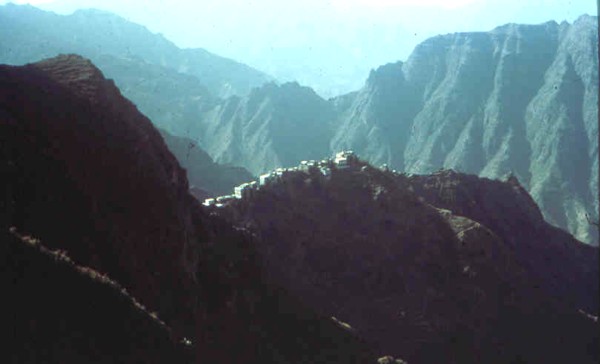
Marib’s position, however, had less to do with access to water, and more to do with incense. The city held a commanding position on the developing inland caravan route that ran from the areas on the Indian Ocean (eastern Yemen today) which produced frankincense across the desert to the Mediterranean. This route wound its way along a chain of watering places between the mountains and the desert.
The caravan trails depended as much on the political situation and trade connections as on the geography of the area. In order to make one’s way from the main centers of production (which were in the eastern Yemen) to the Mediterranean Sea, one had to avoid the mountains, with their difficult passes, feuding tribes, and frequent dens of thieves. At the same time, one had to find enough water and food for men and beasts. There was practically only one trail in South Arabia which fulfilled all these requirements: from Shawl, the capital of the Hadramaut, it went through the desert, following the Yemenite mountain ridge to Timna, the capital of Qataban. From there, it passed via Marib, the capital of Saba, to Baraqish, and on past Jebal al-Lawdh, to Najran.
Being completely level, the track offered no natural obstacles. Artificial irrigation safeguarded water and food supplies for the caravans. It is therefore not surprising that the ancient capitals along this trail were situated at the points where the most important valleys entered the plain.
Pliny the Elder recorded the distance between Timna (the capital of Qataban) and Gaza, the northern end of the frankincense route, as 2,437,500 steps, or 62 days by camel. He was particularly impressed by the prices of South Arabian goods and complained bitterly about Greece’s trade deficit (100 million sesterces). Consequently, the Romans looked upon the riches of southern Arabia with envy. (Pliny Natural History Vol 12.32, Pliney 12I.84)
As money became available through the sale of incense, the Sabeans began to erect large sanctuaries, which were entered through impressive monolithic pillars. Work was started on the stone walls which were to be the fortifications of the towns. At the same time (6th century B.C.), the first written documents in the form of stone inscriptions appear. The oldest of these are very short and invariably refer to religious rites or construction projects. These inscriptions are in Sabean characters, which later became wide spread, extending even to Ethiopia. Some experts feel that the Sabean characters may have been derived from alphabets existing in Southern Mesopotamia. The first mention of a caravan on the so-called frankincense route is contained in the Old Testament. The story in I Kings 10:1-13 tells us of the visit of the legendary Queen of Sheba to King Solomon (about 970 - 930 BC). This report suggests that trade relations were being established or expanded between these two kingdoms. It is generally assumed that Sheba was located in Southern Yemen, although some have argued that it could have existed in Ethiopia. Three Assyrian texts from the 8th and 7th centuries B.C. mention tributes or presents from Saba. These lists of the goods include incense and precious stones. The texts also mention the names of two rulers, pointing to this being a reference to the south Arabian Sabeans, not, as some have suggested, a north Arabian tribe of the same name. Saba lay outside the reach of the Assyrian armies; therefore the tributes cannot have been an expression of political submission. It is much more likely that they were trade tariffs or gifts which were supposed to guarantee smooth trading. Thus the passage constitutes the first, if indirect, reference to Sabean trade with the north. Later, a Sabean named Itamra and identified as a representative of the Sabean ruler, Yitea Amar, is mentioned as one of those who brought tribute, in the great inscriptions of the Assyrian king, Sargon II, dating from 715 B.C. This is most probably due to the fact that during this time the Assyrians had gained control of the port of Gaza where the frankincense route reached the Mediterranean. Thirty years later, around 685 B.C., the Sabean ruler, Karibilu, sent gifts to the Assyrian king, Sennacherib, when the foundation stone for the Bit Akitu temple was laid outside of the ancient Sumerian city of Uruk (biblical Erech).
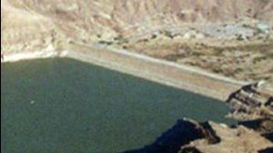
The Marib Dam
As the Sabaean kingdom developed, they built a huge earth filled dam in the second half of the 6th century BC to hold back some of the water that came down the wadi. From the lake that developed behind the dam, they developed a splendid irrigation system that watered about 25, 0000 acres.
During the years that I lived in Yemen, I had the opportunity to visit the ruins of the quarter-mile-long Marib Dam. I also viewed the new modern dam as it was built and the huge water reservoir that filled up behind the dam. When the ancient reservoir re-filled with water, hundreds of old dry wells and water canals scattered through the desert below the dam suddenly filled with water again. The ancient farmlands, that for centuries had lain deserted, were suddenly usable again. Saba extended its territory to the coast of the Red Sea and then it moved on by establishing colonies across the sea in Abyssinia, east Africa. This is proved by the Sabean inscriptions found there. For pictures of the Marib Dam site click here.
The Minaean Kingdom
Over time, various groups splinted from the Sabean Kingdom. Ma’in was originally a Sabean territory, but towards the end of the 5th century BC, it gradually began to sever its ties with Saba. For more than a century it enjoyed a period of tremendous economic prosperity. During this period, the Minaean Empire controlled most of the incense trade routes in southern Arabia. To control and protect this route the Minaeans established a colony far out in the northwest of Arabia, in the oasis of Dedan. The confrontation between Saba and Ma’in for control of the frankincense route is illustrated by an inscription that describes a battle between the Medes and Egypt which is probably a reference to the subjugation of Egypt by Artaxeres III Okhos in 343 B.C. In this inscription, the two leaders of the Minaean community of Dedan express their gratitude for the fact that their property had been saved from attacks by Sabeans on the caravan route between Ma’in and Najran. Further proof of the extent of the Minaean influence is reflected in their inscriptions which refer to Gaza, Egypt, Ionia, Sidon in Phoenicia, Ammon, Moab, Yatrib (later known as al-Medina), and other places. Along with this, an epitaph found on a sarcophagus found in Egypt, recounts that a Minaean delivered perfumes to an Egyptian temple. On the Greek island of Delos, with its temples dedicated to Apollo and Artemis, two Minaeans erected an altar to their native god Wadd, and in the early Greek and Roman world historians spoke of “Minaean frankincense” because it was mainly the Minaeans who produced this much demanded product.
Around 400 BC, Ma’in and Qataban broke free of the Sabean yoke and expanded their territories considerably. At the height of their power in the third and second centuries B.C., Qataban extended its power as far as the Indian Ocean in the south and to within a day’s journey of the Sabean capital Marib in the north. As these other ancient kingdoms of Southern Arabia grew in strength, it became urgent for the Sabeans, seeing themselves hemmed in, to fortify Marib, their easternmost base. They also managed to bring the routes leading into the Yemenite highlands more and more under their control. Some South Arabian inscriptions mention the incense trade as is illustrated in an inscription (about 4th/3rd century B.C.) found on a straight section of the city wall of Baraqish. It runs something like this: “Ammisadiq … and the leaders of caravans, and the Minaean caravans who had set off in order to trade with Egypt, Syria and beyond the river… at the time when (the gods) Athtar dhu-Qabd, Wadd and Nakrah protected them from the attacks which Saba and Khawlan had planned against them, their property and their animals, when they were on their way between Ma’in and Najran. And in the war which was raging between north and south. And at the time when (the gods) Athtar dhu-Qabd, Wadd and Nakrah protected them and their property when they found themselves in the heart of Egypt during the war between the Medes and the Egyptians. Athtar Dhu-qabd guaranteed to them and their property peace and indemnity until they returned to their town Qarnaw.” The Hadramaut
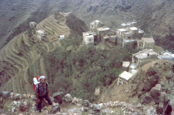
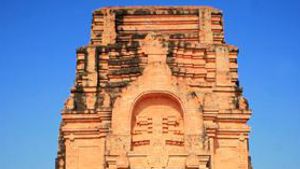
Sabean inscriptions suggest that the Hadramaut was an ally or vassal of the mighty Sabean empire up to the 4th century B.C., when it became an independent kingdom and acquired tremendous economic significance because of its possession of Dhofar, the area in the east where the frankincense grew. A rock inscription at al-Uqla near Shabwa, where the kings of Hadramaut annually re-enacted the coronation ritual, tells of delegations from Palmyra, Chaldea, and India about 235 A.D., whom the ruler apparently invited to attend this important event. One of the outstanding features of the Hadramaut was the ability of their builders to build high-rise buildings from mud. Even today, many mud houses in Hadramaut villages reach eight to nine stories. It is hard to image that well before the birth of Christ, the inhabitants of southern Arabia erected buildings, some of which reached eight stories. When built side by side, ancient towns like that of Shibam, Yishbum, and Sana’a had streets of high-rise buildings. A four-line inscription, today in the Museum of Sana’a, tells of the buildings in the Sabean Himyaritc region that were made of stone.
“Muhabayyih Atkan, son of Manakhum, and Akhal and Bahil and Halilum, of the Musawwilum (clan) have built and founded and improved and completed their stone house Ahdathan from the floor up to a level of six ceilings with six stories, and they have added two (further) stories and all the store rooms and its terrace and the stone structure of Dhu-kahnal.” For “story” the Sabean text uses the word “saqf”, which is the term still used in Sana’a today.
For centuries, these four kingdoms (Saba, Ma’in, Qataban, and Hadramaut) were of more or less equal strength. They rivaled one another for control of Southern Arabia, but in the last quarter of the 2nd century B.C., a shift of power took place. Around 250 BC, the Minaean Empire and parts of western Qataban were conquered by Saba, while Radman, formerly a province of Qataban, managed to gain independence and to rob Qataban of some of its southern territories.
The Himyarites
The Himyarite Empire was founded in 115 B.C., on the corner of the Arabian Peninsula at a place known as Bab-el-Mandeb. Gradually it expanded its control and slowly annexed all the surrounding Southern Arabian states. Saba was conquered in 25 B.C. after the Roman Army, led by the Nabataeans, attacked and weakened Saba. Qataban fell to the Himyarites in 50 A.D., and Hadramaut followed in 100 A.D. From that time on, the Himyarite Empire was Arabia’s dominant state until the sixth century A.D. Like other early Arab states, the Himyarites made a living by selling frankincense and myrrh to the rest of the civilized world. This was such a lucrative business that the Romans called the Himyarite Kingdom “Arabia Felix,” meaning Happy Arabia.
undefined
To date, the first mention of Himyar in Southern Arabia occurs in a Hadramite inscription, dating from the beginning of the 1st century A.D., which reports the building of the wall at Qalat, the later Libna, to protect Hadramaut from the Himyars in the south, who had apparently already occupied large stretches of the coast. The Himyar metropolis, Zafar, was mentioned for the first time as Sapphar in the sixth book of Pliny’s Natural History, written during the reign of Emperor Nero (A.D. 54 - 68). Henceforth Zafar challenged Marib for supremacy and the Himyar rulers even claimed Saba by designating themselves “Kings of Saba (Sheba) and Du-Raidan”, a title which from then on the Sabean kings residing in Marib likewise adopted to stress their own claim to be the sole rulers of Yemen.
undefined
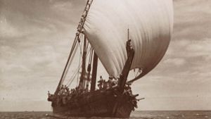
It seems that the Nabataeans allied themselves with the new Himyarite Empire that lay along the southern coast. The other South Arabian kingdoms all had capitals and cities that faced inland towards the incense trail. These kingdoms refused to export incense by boat, and relied totally on Arab camel caravans to carry their goods north. The Himyarites on the other hand, floated their frankincense out to an island where the Nabataean boats collected it and transported it to the markets in the north. Within a few years, the Himyarite Empire grew in strength and power, while the other kingdoms struggled and eventually caved in to Himyarite domination. By transporting incense with boats, the Nabataeans gained almost exclusive control of the frankincense trade between Arabia Felix and the Mediterranean. Over the next several centuries the Nabataeans capitalized on this monopoly, raking in incredible profits.
undefined
As we mentioned earlier, the Nabataean profits grew and the Romans became concerned about the drain the incense trade was making on their economy Things became so bad, that in 24 B.C. Aelius Gallus, the Roman prefect of Egypt, decided that an expedition had to be sent to Arabia Felix to discover the source of the incense. He insisted that the Nabataeans guide his soldiers in the expedition. The Nabataeans were of course initially dismayed until Seleucius, the brother of the king realized how the Roman Army could be used to crush Saba, the Mineans, and the Hadramaut and thus help transfer power to the Himyarites, friends of the Nabataeans.
Rather than making the entire journey by boat, the Romans, under Seleucius’ guidance, landed on the coast of Saudi Arabia, and made a difficult journey through the rocks and sand. Hundreds of Roman soldiers died on the journey. Once in the Hadramaut, more soldiers died from disease and exposure. Najran was conquered and several Minaean towns were destroyed. Others opened their gates to the enemy. Marib held out, however, and in the end, the Romans were forced to retreat through lack of water and disease.
The expedition had failed only a few miles from the frankincense fields. For the Romans it was a disaster. Seleucius was later executed by the Romans for failing to bring the soldiers successfully to their goal. However, the expedition was probably a success for the Nabataeans as the Roman foray upset the balance of power in Southern Yemen, allowing the Himyar Empire to expand its area of control against the war torn areas, as soon as the Roman army had left.
As the demand for frankincense grew, the Hadramis from the Hadramaut introduced a second harvest of frankincense in Dhofar. Nevertheless, even this was not enough. Pliny mentions that a few dozen million sesterces went to Rome from the Himyarite Kingdom. Then at the funeral of Nero’s wife (65 AD), Pliny the Elder tells us that an entire year’s harvest of frankincense was burned. This created massive shortages of frankincense throughout the entire Roman world.
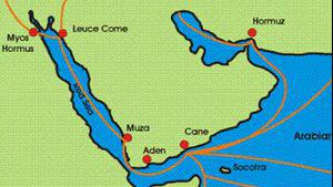
The Nabataeans by this time were almost exclusively making use of the sea route, loading frankincense from their island port in South Arabia off the Himyarite coast. This port was out of the control of the warring kingdoms of Southern Arabia and provided a secure place for them to conduct commerce. These goods were then moved north by boat, and unloaded at the Nabataean port of Leuce Come where Nabataean caravans moved them north to Petra and west to Alexandria and Gaza. It is interesting to note that the Nabataeans also set up a military fort at Leuce Come so that they could tax the incense that still made its way through the traditional overland route. The tax was set at one quarter the value of the caravan’s load. Farther inland the Nabataean center at Meda’in Saleh was situated at the inland caravan cross roads and controlled all of the trade passing through that point.
undefined
Eventually the Himyarite Kingdom suffered a permanent economic slump because of Christianity’s success, and the decline in the demand for incense. For centuries the Egyptians had stuffed mummies with myrrh, and Greeks & Romans used frankincense to cover the odor of burning flesh at cremations. Since Christians buried their dead, instead of burning or embalming them, the demand for frankincense and myrrh dropped dramatically as Christianity spread in Europe.
The Final End
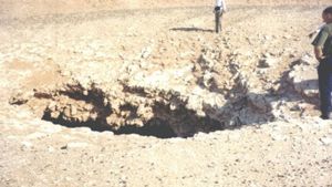
The first record of the breach of the Marib dam is found in an inscription stemming from the reign of Ta’ran Yuhanim and his son Malikkarib Yuha’min in the second half of the fourth century AD. Then in 542 AD, the Marib dam was breached again.
The beginning of the seventh century witnessed the final destruction of the Marib dam. This disastrous event, referred to in the 34th surah of the Qur’an as “the Flood,” caused the desolation of the Marib oasis. Following the death of Khosrau II in 628, the Persian governor in Southern Arabia, Badhan, converted to Islam and Yemen followed the new religion. Thus for the first time in history the Arabian Peninsula was politically united and able to build up strength to a level unknown during the time of the competing kingdoms of Southern Arabia.
Modern Discovery of Ubar
Today southern Arabia is the center of a flurry of archeological activity as historians try to piece together the puzzles of history, especially the history and location of the fabled towns and cities of the frankincense trade.
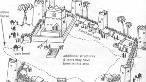
The legendary city of Ubar was once a center of trade and wealth. According to legends and accounts by early historians, this city was fabulously wealthy as it was located on the overland incense trail.
One day, however, (as legend tells us) a prophet arrived on the scene and approached the last king of Ubar. This prophet foretold that the city and the entire civilization of Ubar would be destroyed by God, as punishment for their wicked living. The king ignored him and a short while later the city disappeared from historical record and was buried under the sands of the Empty Quarter of Arabia.
For centuries, travelers in Arabia have looked for the lost city. Then, in February 1992 an article by John Noble was splashed across the front page of the New York Times, declaring that the lost city of Ubar had been discovered. This article was then relayed all around the world and excitment grew. “Guided by ancient maps and sharp-eyed surveys from space” the article claimed “archaeologists and explorers have discovered a lost city deep in the sand of Arabia.”
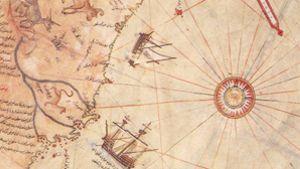
The article claimed that a geologist and specialist in space remote-sensing technology from the Jet Propulsion Laboratory in Pasadena, California by the name of Dr. Ronald G. Blom, compared maps made by Ptolemy, the Roman historian, with photographs from Landsat space satellites. He hoped that he could identify sites that archeologists could later investigate on the ground. From the Landsat pictures, however, he discovered that there were no ruins of any ancient cities visible. However, because so little changes in the deserts of Oman and Yemen, he could see ancient paths and tracks in the desert. These tracks had persisted for a very long period, and after careful computer processing, the scientists were able to make them out on the Landsat pictures. The ancient tracks acted like a road map. The scientists assumed that where many tracks merged, an ancient city must exist. When the archeologists arrived at the spot that Dr. Blom had pointed out, they indeed discovered the ruins of a very ancient city in the deserts of Arabia. It is assumed that these ruins are the remains of ancient Ubar.
Dr. Juris Zarins who was part of the expedition later commented: “The truth is, it was found by hard work, and excavation. The satellite imagery allowed us to eliminate sites so we could concentrate on the most probable areas.” Ranulph Fiennes later published his account “Atlantis of the Sands” Bloomsberry 1992 (right) as an effort to correct this misrepresentation. The LandSat photos were helpful, but the camel caravan routes through the desert had been noted many years before. When they started digging at Shis’r, near an old Arab fort, they began to uncover a large ancient structure. No one was sure what it was, until the article appeared the the New York times. Suddenly the world was convinced tht Shis’r was Ubar. But is the academic world convinced? Todate, no one has published any proof that links the structure at Shis’r with Ubar.
See shisr.html for more information
Trade Routes
A new expedition by George R. Hedges, a Los Angeles lawyer with a background in archeology, recently returned from an extensive reconnaissance in trucks across the Mahara region of Yemen. Covering some 2,000 miles in three weeks, the team found the ruins of two limestone fortresses which are similar in design and construction to those in the incense region of Oman.
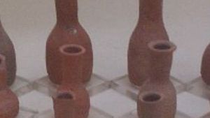
They also came upon distinctive stone monuments, called triliths, that appeared to mark caravan routes. Along the way, they collected shards of pottery in a style corresponding to that found at frankincense sites in Oman. Mixed with the local pottery were pieces of red-painted ceramics from ancient Persia, giving further evidence that there was a good amount of the trade with the Persians, even during the Roman era.
This team also followed photographs from Landsat spacecraft. But, as usual, the local tribe people knew more than the technology-savvy scientists. A police colonel in the town of Sayhut told the researchers about an old fort that was located up a wadi outside of the town. The fort proved to be the first impressive find, and seemed identical to the fortress at Ubar, in Oman. Along with this, the pottery fragments there were nearly identical to those found earlier.
Within the thick stone walls of the fort stood a central castle-like building. At the base of the hill were the traces of an ancient settlement and agricultural fields. The fort was located over 400 kilometers (1240 to 300 miles) from Ubar, and supports the theory that the Ubarites controlled a large section of trade in eastern Yemen.
Pliny the Elder, in the first century A. D., reported that the frankincense region could be found by traveling a route from Shabwa, an ancient city in Arabia Felix that still exists today. From Shabwa, there was a marked route with eight small fortresses or rest stations located at various stages.
Archeologists believe that the forts they located are two of the intermediate fortresses on this route. They came upon the second fort on a plateau overlooking the Minar wadi. This fortress resembled in all the important respects, the other known sites. The pottery found there dated the fort to the heyday of the frankincense trade, 200 B. C. to about A. D. 300.
Between the forts and elsewhere in the region, are more than 30 triliths. These lines of standing stones, three to a group and about three to five feet high, were markers along the trade routes. These triliths conveyed distances, locations of water sources and directions. The whole region where these forts and trade routes are located in the location that was labeled by Ptolemy as Myrrifera Regio, roughly translated as Myrrh country.
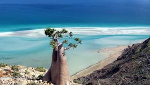
Throughout this region of Yemen are large groves of myrrh trees, some over 10 feet high. The local Yemeni’s still tap the trees to produce myrrh, which they sell in the local markets in Yemen.
Frankincense on the other hand, comes from the Qara Mountains, which are located along the coast of Oman. In these mountains, the monsoons of the Indian Ocean provide more moisture, allowing the frankincense trees to flourish.
Nabataean Connections
Directly north of Petra is a small but significant archeological site called Tawilan. It lies above the entrance to Petra. There have been people living in Tawilan since the end of the eighth century BC, probably the earliest time when the Nabataeans may have entered the area. Large amounts of painted pottery from the sixth century BC were found at this site, including, of all things, a Sabean seal. Such a seal would only have been in the possession of a Sabean government official, or an official representative of the Sabeans, (or perhaps a criminal or con man). Along with these items, an altar was found, with a crescent shaped moon carrying the disc of the sun. This is typical of the sun worship that took place in the Sabean kingdom.
It is apparent that the Nabataeans had almost exclusive control of the frankincense route from 100 BC to 300 AD. During these four hundred years, they built an impressive economy, and expanded their trade base to include many of the trade items that were in demand in the Mediterranean region.


Page Discussion
Membership is required to comment. Membership is free of charge and available to everyone over the age of 16. Just click SignUp, or make a comment below. You will need a user name and a password. The system will automatically send a code to your email address. It should arrive in a few minutes. Enter the code, and you are finished.
Members who post adverts or use inappropriate language or make disrespectful comments will have their membership removed and be barred from the site. By becoming a member you agree to our Terms of Use and our Privacy, Cookies & Ad Policies. Remember that we will never, under any circumstances, sell or give your email address or private information to anyone unless required by law. Please keep your comments on topic. Thanks!