The Indian Circle method of establishing ancient Qiblas did not take into account the curvature of the earth. How badly did this affect the Qiblas set with this method? This is the last video in a series of 6 videos on how the first generation of Muslims set the Qibla direction in their mosques.
Transcript
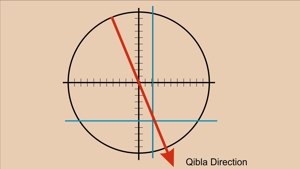
Indian Circle Issues
Hello, I am Dan Gibson, and this is the sixth and last video in the series Navigation and the Qibla.
In this video series we have introduced the method that the ancient Arabs used to determine Qibla direction.
This method was not invented by Muhammad or the new Muslim community. By their time in 600 AD it was a very old method, having been in use for many hundreds of years. Way back in 70 AD, during the height of the Nabataean Empire, Pliny the Elder was told by the Arabs that the trip from Timna, the capital of Qataban in Yemen, to Gaza on the Mediterranean Sea was 2,437,500 steps, or 62 days by camel or around 2,500 KM as we would measure it today.
The Nabataeans were not simple merchants or camel drivers, taking a few good from one city to another. I think that is a mistake often purported by people who want to demean the Arab people and their accomplishments and their history. The Nabataean Empire was very different other Empires. It was not built on military might but on economic strength and control of resources.
The Nabataeans had built a network of trading emporiums all across the Middle East, and into Europe. Nabataean families would set themselves up just outside of foreign cities, with room to store goods. Then they would seek out trade good produced in that city or region, and when the price was low they would purchase and hold those goods.
When the camel caravan arrived, they would send those good to other places, and unloads goods that would bring good prices in their city. Many of the Nabataean merchants did not sell directly to the public, but rather sold in bulk to local merchants. In many ways they were the original wholesale distributors. Evidence of small Nabataean communities has been found near many major cities all around the Mediterranean and beyond including even Italy itself.
But some of the supplies, such as incense from Yemen required a long and difficult trip across the desert. Now most of the deserts in the Middle East are like huge flat plains of gravel, with some rocky areas. The great sand dunes you see in photos are mostly in small areas. However, there is one very large area, known as the Empty Quarter, because it is mostly made up of sand dunes that blow and shift across the flat rocky plain.
This flat area was perfect for the Nabataean merchants who realized that the farther north they moved the higher the North Star rose in the sky, and the farther south they traveled the further down the North Star hung in the sky. It wasn’t long before they were measuring the height of the North Star with their fingers extended at arm’s length. This was the beginning of their fascination with the stars.
At the same time, the only way to get an accurate measurement of the distance they had traveled was to count their steps while they walked. Remember, camels carried goods, both directions, and the camel drivers walked, so that the camels could carry maximum loads.
And so the Arabs learned to chant poetry or stories while walking beside their camel caravanss. It helped with the rhythm of walking, but more importantly each poem was long, easily remembered, and had a known length. When they started on a long poem or story, they could stop counting, because when the story ended they knew the number of steps they had taken by the number of beats in the poem.
Over time, many of these poems and stories were lost. But some were remembered and centuries later were retold and became part of a collection of stories that became the ‘Thousand and One Nights’. Some of the earliest Arabic poetry found its way into this collection. On top of these, there are what are known as the hanged poems, which supposedly were created in pre-Islamic times. These stories have been translated into English or other languages, and so we don’t hear the rhythm and the poetry. I have a collection of the stories in Arabic behind me, in 6 volumes.
In the Bedouin villages I would often hear people quote these stories from memory, and in every case they were like poetry, with rhythm and beat. And these are the kinds of stories that the caravan masters knew, and used to keep rhythm as they all walked along, and to measure the number of steps the caravan took. In Europe merchant caravans used a drum, known as the Walking Drum to beat out the rhythm while they walked, but they didn’t receipt poetry or stories like the Arabs did. The Arabs did not have a walking drum. The Arabs were known as the Singing caravans, with everyone chanting along as the story was told and the distance measured.
So with all of the information that the Arabs gathered, they could start their caravans moving, knowing what direction they were heading for, and how far it was going to take them.
Then each night they would choose the next night’s stopping place along the route, and in the morning they would head for that place. It was over the horizon but they had the tools to help them walk across the vast desert plains and arrive exactly where they wanted.
And so it was not hard for them to take the navigational tools that they developed over the centuries, and use them in their new religion. When Muhammad directed them to face a certain place, far over the horizon, it was not impossible for them to do, because there were men among them who had the tools and the knowledge to do this.
You see, the Qur’an does not command the followers of Allah to do something they could not do. Allah was not expecting them to do the impossible. The first generation of Muslims had the knowledge and ability to orient their new mosques with a reasonable degree of accuracy. They didn’t require the absolute exact direction. Getting within a couple of degrees was sufficient, because they would line up in a long wide line facing the Qibla direction.
And when we use the Qibla Tool, and examine some 160 mosques, starting from the first mosques built in Medina, we can see a pattern of accuracy. They didn’t choose random directions. They didn’t copy something they saw or imagined when visiting Mecca, and then incorporate it into their mosque somewhere else. The Qiblas of the ancient world are systematic.
That is why it is important to understand the story that the archeological evidence presents us. You see, by the Middle Ages, Islamic leaders had purified the story of the founding of Islam. Islam was no longer conquering great swaths of land. Now Islam was being spread ideologically, and preachers, not military commanders were leading the way.
And the preachers preached a message of a pure Islam. They preached that the Qur’an descended from heaven, rather than was revealed a little bit at a time to Muhammad during his lifetime. Some of the more embarrassing events during the rise and development of Islam were covered over. For instance General Hajjaj and his invention of the Wasit, or middle, or between Qibla were no longer mentioned, and within a generation or two were forgotten and a ‘politically correct’ version of the story of the founding of Islam was believed by everyone everywhere.
And so when confronted with strange Qiblas, people imagined that the early Muslims were clueless about how to accurately face themselves when they prayed. This belief about the early Muslims being unable to correctly follow the command of Allah and face Masjid al-Haram was suggested by some of the medieval mathematician and astronomers. When they saw that some of the early Qiblas seemed to be very inaccurate, this was their assumption. After all, they were trying to convince the people of their day that mathematics and astronomy were superior to whatever the ancients used.
Now even today, this idea of the early Muslims being ignorant of how to set a Qibla, and being happy to select some aspect of the Ka’ba building and replicate it at home, is propagated by the likes of Dr. David King. He strongly argues that the first generation Muslims had no way of knowing how to set a Qibla, and any appearance of systematic Qiblas is simply by chance. And so Dr. King’s challenges the Muslim world, and he challenges all Muslim scholars anywhere to demonstrate to him how the early Muslims could have established their Qiblas with any accuracy.
That is what this video series is all about.
And we have demonstrated in the first five videos that the first generation of Muslims did indeed have the tools and the ability to set accurate Qiblas, using something known later as the Indian Circle.
In this video we want to explore two further questions.
1st: Since the Indian Circle did not take into consideration the curved surface of the earth, how much of an error would this have introduced?
2nd: If the first generation of Muslim used poor quality counting of steps, how badly would that have affected their Qibla setting?
First, the curvature of the earth.
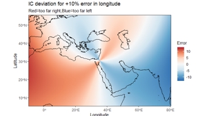
Let’s look at this graphic made by a mathematician / statistician. I asked him to graphically represent the difference between a true Qibla that takes into account the curvature of the earth, and the Qibla direction given by the Indian Circle. This assumes that the first generation of Muslims had accurate data. So in this graphic we are just testing the accuracy of the Indian Circle method itself. Later we will look at the accuracy of the data.
The lighter areas are the most accurate, and the darker areas are where there is the most error. As you can see the further east or west one goes, the greater the error. By the time one reached India in the east, or Morocco in the west, the error introduced is as much as 10 degrees. So if they used the Indian circle in Morocco, the resulting mosque would face 10 degrees farther south than it should have.
The same is true in India, if the Indian Circle method was used in north India, the qibla would face 10 degrees farther south than it should have.
Remember we are comparing the difference between the direction based on Indian Circle and the actual direction based on GPS coordinates which take into account the spherical shape of the earth.
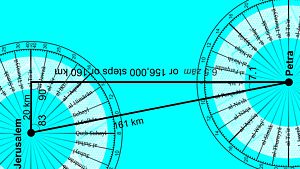
In the graphic we are using a Qibla based on Masjid al Haram in Petra. Notice that directly north and south, Indian Circle is accurate. (That is based on the lighter color)
Notice also that there is circular area where the Indian Circle would be more accurate. Outside of that there are places where it will be less accurate. The reason for this is the curvature of the earth.
Now let’s go to the Qibla tool on the Nabataea website.
On the right hand side of every location, we show the direction to Mecca, to Petra, to Jerusalem and to the Wasit or the Between locations.
Then we provide the option to see the farthest extent of the sun during the summer and winter solstice to see if they had anything to do with establishing the Qibla.
Below this we have added three more options. For each position we provide the option to see the Qibla direction that resulted from the Indian Circle method. For each of these you can turn them on or off, and see the result on the map.
So let’s choose Anjar. I choose Anjar because it is easy to see. It is large in size, with no interfering buildings. Plus it has an inscription that tells us it was built in year 95 of the Hijra. The entire complex is oriented in one direction, including a mosque near the centre. It is a good place to illustrate what takes places when we consider the Indian Circle.
The Blue line shows us the orientation of the complex and the mosque.
The other four lines show us the GPS directions to Jerusalem (in Black) Petra in Red, Between Qibla in Yellow, and the Green Qibla for Mecca.
I have classified Anjar as having a Petra Qibla, because it is the closest.
Now, let’s click on the solstice. As you can see the solstice has little to do with the orientation of these structures.
I am going to zoom in closer.
I will click on the Mecca Indian Circle option, and you can see that the Indian Circle would have set a Qibla slightly to the east of the actual GPS set Qibla.
If I click on the Between, you can see that it would have been almost exactly right.
If I click on the Petra option for the Indian Circle it would have produced a Qibla to the west of the real Petra Qibla.And this is very close to the Qibla that was used in 95 AH at this location.
Now if I move farther west, into Africa, what happens then?
Let’s go about half way, and check out the Qibla in Zawailah. It was built in 68 AH.
The Blue line shows us the Qibla of this mosque.
If I turn on the GPS Petra Qibla, I can compare it with an Indian Circle Qibla.Notice that the Qibla would point a bit to the south, but it does not explain the mosques Qibla.
If I turn off the Petra Qiblas and turn on the Mecca Qiblas and then the Indian Circle Qibla it is closer but it still does not explain the Qibla used in this mosque.
So let’s go much further to the west to Cordoba, built in 168 AH.
If I turn on all the GPS set options, we can see that they do not explain the Qibla of this mosque.
Let me turn them all off, except for Mecca, and then add the Indian Circle method, it still does not explain the Qibla of this mosque.Even by taking into account the spherical error in the Indian Circle method, it does not explain the Qibla used in Africa and Spain.
To understand the Qibla used in North Africa and Spain, please see the videos I recorded on the Parallel Qibla. Those videos tell the story of how this Qibla developed, at the very same time that Al-Hajjaj was developing his Wasit Qibla in Iraq. All we are demonstrating here is that the Parallel Qibla does not seem to be connected to the Indian Circle Method of setting a Qibla.
Now, one more graphic.
What would have happened if the Arabs had used Ptolemy’s measurements of the earth? He mis-measured the earth, and got it too small. That’s why Christopher Columbus thought that China was much closer than it really was. If the Arabs had made the same mistake as Claudius Ptolemy, and had used his coordinates, rather than counting actual steps, what would that have done to the Indian Circle?
This graphic shows us that the Indian circle would have been much more accurate.Erring on the side of longitude being too short, would have evened out the errors introduced by not calculating the curvature of the earth.
So let’s review:
The early Arabs were traveling merchants who used the stars and counting steps to navigate across the deserts of the Middle East. When Muhammad revealed the Qur’anic verses commanding the faithful to face Masjid al-Haram, and having it as their Qibla, they had no problem in doing this, because as desert navigators they already had the tools in hand. Using their measurements of the height of the North Star, and the counting of steps as the caravan moved along they could accurately determine where Masjid al-Haram was, even when it was hundreds of miles away over the horizon.
Today a few scholars dismiss the Indian Circle as an inaccurate tool, because it did not take into account the curvature of the earth.
The Indian Circle treats the world as a flat surface.
But as we have shown the greatest error that would have been introduced is 10 degrees for mosques as far away as Morocco or Pakistan.
Now, by 900 AD when it became widely known that there was something odd or wrong with the Qiblas of the first generation of Muslims, it was assumed that their method was bad.
So Muslim scholars were looking for more accurate ways to determine the Qibla. They wanted NEW techniques, rather than the old ones. There whole focus was on the mathematics and the science behind the Qiblas, rather than on history. They could not image that back in history they might have been accurate. They just saw all these inaccurate Qiblas. They had no idea there were multiple Qiblas, 4 Qiblas in the early days.
Now let’s deal with one more question.
Many people have questioned, and even have made fun of the Qibla that was set in Guangzhou in China. My research has been ridiculed by some for various suggestions.
That the Arabs would even have been in China, and that they would have built a mosque during the lifetime of Muhammad. I have tried to demonstrate this in my videos… that there had been an exchange of explorers and then merchants between Arabia and China as early as 100 BC. People who make fun of the Arab-China connection are simply ignorant of the historical connection between these civilizations.
There were two routes to China. One was across land, using the ancient Silk Route. This route was active during the time of the Roman Empire. The second was a maritime route between China and the Arabs. You can check out this route on my website site Nabataea.net. Just click on: Explore, then Travel and Trade and then the Ancient Maritime Sea Route.
Third, people have ridiculed the Guangzhou mosque qibla, because they say there was no way the Arabs could have calculated the Qibla. But I disagree.
Measuring the North Star they would have discovered that the mosque in China was a little south of the city of Petra. They didn’t need to know exactly how far they were from the Middle East, all though merchants traveling across land would have had a good idea of how many steps they had taken; the mosque builders could have estimated, and faced their mosque a little north of straight west. And they would have been very close to the actual Qibla.
I hope I have been able to demonstrate that that the first generation of Muslims were NOT ignorant, and unable to obey the command of Allah to face Masjid al-Haram whenever they prayed. I firmly believe they had the tools and the ability to set accurate Qibla directions for their mosques… accurate at least to average within 3-4 degrees.
I am Dan Gibson and this has been the last video in the series Navigation and the Qibla.
Page Discussion
Membership is required to comment. Membership is free of charge and available to everyone over the age of 16. Just click SignUp, or make a comment below. You will need a user name and a password. The system will automatically send a code to your email address. It should arrive in a few minutes. Enter the code, and you are finished.
Members who post adverts or use inappropriate language or make disrespectful comments will have their membership removed and be barred from the site. By becoming a member you agree to our Terms of Use and our Privacy, Cookies & Ad Policies. Remember that we will never, under any circumstances, sell or give your email address or private information to anyone unless required by law. Please keep your comments on topic. Thanks!