Click below to watch the video:
Navigation and the Qibla Video #3. Calculating Distance After establishing the four cardinal directions (video 1) and then the 224 degrees in the Arab Windrose compass (video 2) this video explains how early Arab merchants measured distance in the desert.
Transcript
Hello, I am Dan Gibson, and in this video series we are examining the question: How did the early Muslims calculate the Qibla direction of their mosques?
In the first video we introduced the topic, and then examined how the ancients could accurately draw lines on the ground that were within one degree accuracy of the four cardinal directions: North, South, East and West. In the second video we discussed how they would fill in the rest of the chart, known to us today as a Compass Rose, or a Windrose.
This chart could be drawn on the ground, with 32 points, and within a degree of accuracy. In that second video we learned that an Arab circle had 224 points or degrees. There were 32 akhnam or directions, and these were broken down farther into zams. So 8 zams made an akham, and 32 akhnams made a complete circle. Not 360 degrees. The Arabs had 224 degrees or zams in a circle, and I would like to encourage you to try and think as an Arab navigator and work with these 224 degrees.
Now if you have ever been on a road trip, you know that kids are always asking: Are we there yet? The Arabs were no different. They wanted to know how far it was from one place to another.
Once our architect had drawn his compass points on the ground, he needed to be able to measure distance. He might want to measure a few feet, he might want to measure several thousand feet or he might want to measure several million feet. Measuring distance was a key to ancient merchants being able to know where they were heading; whenever they set out to travel across desert wastelands.
These ancient merchants go way back into history. Nabataean merchants were traveling across the deserts of the Middle East long before the time of Christ.
You see the deserts of Arabia separated the great civilizations. Egypt on one side, Babylon and Mesopotamia on the other side. Assyria in the north, Yemen in the south. And between them vast plains of small pebbles and rocks, plus sand dunes that blew and moved across the plains. These merchants were the glue that held the Middle East together. They were vital to the economies of these great empires. Plus they were the means of communication between them. Good cheaply available in one place, were in demand across the deserts. New discoveries in one civilization were wanted across the desert.
So these merchants needed to know where the target city was, beyond the horizon across the desert. Trade routes were not roads laid out on the ground. Camel caravans used different routes, especially if there were hostilities between civilizations, or if local people wanted to tax them for crossing their land. So trade routes were constantly shifting. Navigators were constantly recalculating their route, as they headed for the unseen cities over the horizon.
Later mosque builders would use the same knowledge to allow them to orient their mosques so that the Qibla wall faced the Ka’ba in the far off Holy City of Islam, which was over the horizon.
So in this video we are going to learn about how the Arabs measured distance.
First of all, let’s see what the Roman historian Pliny the Elder noted about the Arab merchants in his day. He was born around 24 AD, so he was around during the New Testament era and the establishment of the early church. (Pliny 12, Chap. 13) But in this case, we are not interested in Christian history, but in Arab history. Pliny the Elder noted that the Arabs of his day counted their steps when they were traveling across the desert. I am sure he thought this was rather strange. Pliny recorded that the trip from Timna, the capital of Qataban in Yemen, (the source of frankincense) to Gaza, a port on the Mediterranean Sea was 2,437,500 steps, or 62 days by camel. So this was the distance that the incense caravans traveled when bringing incense from Yemen to the Mediterranean coast.
Now a ‘step’ is different from a ‘foot’. A foot is short, but a step is longer. Arab men were about 5.5 feet tall, so there were about 1000 steps in a kilometer. But early Arabs did not have kilometer measurements. They just counted steps. That is why they could tell Pliny the Elder that there were 2 million, 437 thousand, five hundred steps on that particular caravan route.
\ Now, once again, there was both a measurement on the ground as well as one in the sky. Steps were counted on the ground. But there was a way of measuring in the sky as well.
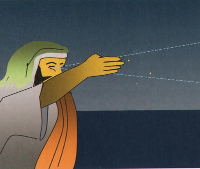
\ When the caravans left Yemen they traveled north to reach the Mediterranean. Centuries before this the Arab merchants had noted that the North Star was relatively stable in the night sky. As they walked north, the star rose higher in the sky. If they would have made it to the North Pole, the North Star would have been directly above them, where as if they were at the equator they could not see it as it was at the horizon or below it.
So the Arab merchants began to measure the height of the North Star. Since the plains of the Arabian desert were mostly flat, they would measure from the horizon to the North Star. In time the Arabs learned to measure all of the 32 stars of the Windrose which we introduced in the last video. It was an excellent way of telling time. But that was later. Initially they only calculated from the North Star.
This measurement of the height of the stars was known as the science of qiyās (measurement of stars above the horizon).
You can read extensively about this in Aḥmad ibn Mājid al-Najdī’s book: Kitāb al-Fawā’id fi uṣul al-baḥr wa’l-qawā’id. (1421 CE) This book has been translated by G. R. Tibbetts and published under the title: Arab Navigation in the Indian Ocean before the coming of the Portuguese. (The Royal Asiatic Society of Great Britain and Ireland, 1981).
I have a copy of the book here, and have gone through it multiple times. This book tells us how the early Arabs used both ishārāt (local guides) as well as majra (celestial guides) to navigate. While this book was not written until 1421, Ibn Majid fortunately gives us some clues as to how the Arabs navigated in more ancient times and how navigation developed up until his time.
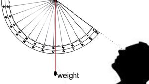
So to determine distance north and south a measurement was taken of the height of the North Pole star. The width of a finger (iṣba’) was used for a rough measurement. Like the Arab Windrose each iṣba’ was divided into 7 zāms.
Measuring the height of the Pole Star using fingers
Over the years I have tried various experiments measuring zāms by hand and I’ve discovered that this seems to work for the average human, no matter how tall nor how short. When holding the hand at arm’s length, it is possible to measure the height of the North Star by simply placing one hand over the other, and then deciding where on the final finger the Pole Star was located, thus measuring the iṣba’ (number of fingers) and the zāms (1/8th of a finger.)
If you want to be more accurate, then an iṣba’ can be measured in the night sky. It is the width between two stars: al-‘Aiyūq (Capella) and Dhubbān (β-Aurigae).
To standardize the iṣba’ measurement Arabs considered the bright star al-‘Aiyūq (α Capella) to be 4 iṣba’ (fingers) from the nearby star called ‘Ayyuq (β-Aurigae). The width of 4 fingers was called a dhubbān. So one dhubbān was made up of 4 iṣba’, and one iṣba’ was made up of 8 zāms.
It wasn’t long before the Arabs began using small pieces of wood, that had dhubbān, iṣba’, zāms, and various combinations marked on the wood. The wood could then be held at arm’s length to get a more accurate measurement.
Ibn Majid quotes an old poem which says: (Tibbetts 1971: 317) My instrument for qiyāsī is 24 pieces of wood. So when the ancient Arab navigator considered north and south, his view of the world was measured in iṣba’. No matter where he was in the Northern Hemisphere, he knew how far he was north or south compared to other locations.

Using a Kamal to measure stars
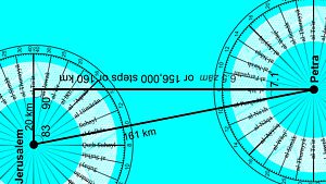
The Arab Navigators memorized the names of major cities, and the iṣba’ measurement associated with that city. According to the map below: Gaza was at: 17 iṣba’ 5 zāms Jerusalem was at: 17 iṣba’ 6.5 zāms Petra was at: 17 iṣba’ Najran in Yemen 8 iṣba’ 0.2 zāms
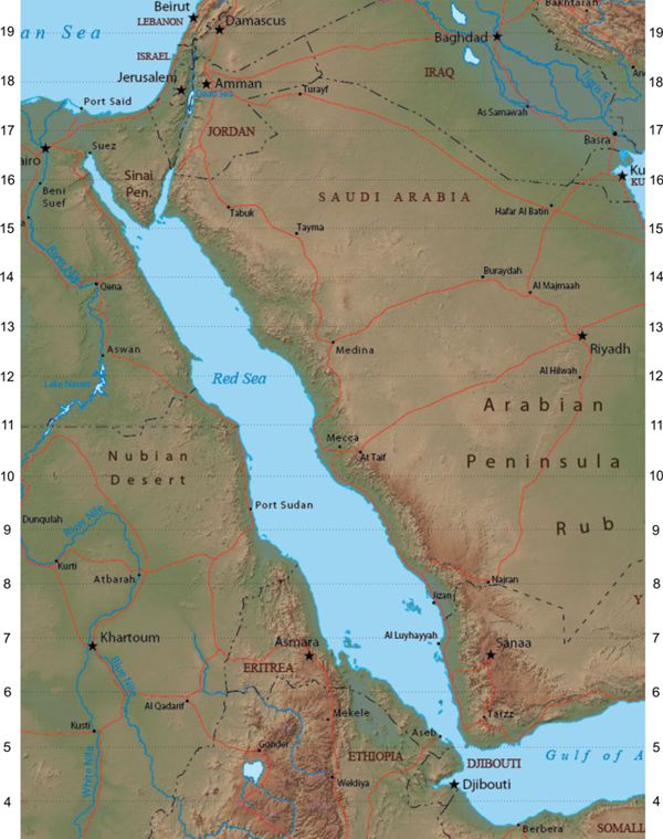
Red Sea by isba and zams.
The iṣba’ associated with each Nabataean trading centre was memorized so that the navigator could quickly tell how much further north or south he needed to travel. In time the Nabataeans ventured as far as India, as so iṣba’ numbers were memorized of the major centers in India where the Nabataeans traded.
The first record we have of the Arabs traveling to China was in 25-55 AD. At this time a Chinese envoys visited the Middle East and on his return to China he brought skilled Arabs from the Nabataean court.
The Chinese noted that among these skilled Arabs there were: Quote “musicians and some skillful jugglers who performed transformations, belched fire, changed the head of an ox to that of a horse, amputated limbs, and then replaced them. They also know how to play with little balls and can keep as many as ten in the air at a time.” No doubt among the skilled Arabs were astronomers and navigators. If nothing else, the skilled Nabataean Arabs would have known how to measure the iṣba’ of the Chinese cities they visited.
It is little wonder, that Arabs soon after this began seeking out both land routes and maritime routes between Arabia and China.
Lets go back to Pliny the Elder. He was told that it took 2,437,500 steps to walk from Timna (Qataban Yemen) to Gaza. That is 14 iṣba’ and 3.4 zāms.
So when the young Arab kids would ask: Are we there yet? The parents could answer. “I don’t know. You check the stars and tell us.” Now, I would like to deal with a question that often comes up at this point in my lectures. How did the ancient Arabs keep track of their steps while they traveled? I remember walking with my sons in the Arabian Desert trying to count our steps. We always had difficulties, because it’s easy to become confused with your numbers.
The Arab solution was brilliant. They didn’t count. Rather they recited poetry. Poetry has rhythm, and it aids in the marching of the caravan. In Europe in the Middle Ages they used a drum. When you heard the walking drum, you knew a caravan was near, or an army. They used drums as well. The Scottish used drums and bagpipes for marching.
But the Arabs used poetry with a distinct marching beat. As they walked along, someone would begin to recite a long poem. Others would take it up, and sometimes everyone would be repeating it together. And so Arabs became known for their very long poems. And each poem had a number attached to it. For non-Arabs it seemed like a magic number. In fact, the earliest Arabs did not use numbers; they used the first letters of the alphabet. This goes back to pre-Arabic times, to the use of Nabataean letters as numbers. Now only a handful of the earliest poems survived to this day. Most of the poems were lost along the way, or later people who recorded these poems just turned them into stories, and the rhythm of the caravan was lost.
In fact, when these Arab stories were translated into English, the translators were totally unaware of the importance of the rhythm. Back in the 1700 and 1800s it was common for Europeans to refer to the singing caravans of the Arabs. To the western mind, the chanting caravans were just singing. Europeans were interested in translating the stories… what did they say? because they thought the stories were the key. But it wasn’t the stories, it was the rhythm that was important.
With the coming of Islam, major changes came to the Middle East. One of these changes was that the Arabs moved out of the deserts, and began to invade lands previously held by the Roman Empire. In the Roman Empire there were roads which were marked with milestones. The Muslim armies no longer needed navigators to lead them across the deserts.
And so by the time of Muhammad, around 600 AD, the use of desert navigation was fast coming to an end. Goods were transported from Yemen north to the Roman lands on boats. Dhows not camels carried goods. Desert navigators were not in need. Routes were well laid out. Sea navigation was needed, and the chanting of poetry made no sense on the seas. Other methods for navigation had to be developed by the Arabs to enable them to cross oceans of water and arrive at the port they wanted. But up until the time of Muhammad, poetry remained an important part of desert navigation.
Much of our knowledge of early Arabic poetry comes from Al Farāhīdi). (Abū ’Abd al Raḥmān Khalīl ibn Aḥmad al Farāhīdim 718 – 791 CE. Book: Kitāb al-’Ayn) He lived over a hundred years after the use of poetry for navigation fell out of use. Al Farāhīdi wrote an early dictionary of the Arabic language (in 8 volumes). He also collected samples of fifteen scales of poetry known in his day and compared them with the Qur’ān.
Because the day of desert caravans and navigation by the stars had long passed, Al Farāhīdi called the meter of the poem the wazn (weight or scale) rather than the earlier term of taf’īla. He also called each line the bayt or house (verse), which could be divided into sections called shaṭr (or half lines)
Al Farāhīdi classified poetry into fifteen types based on their wazn. These more modern forms overshadowed the importance of the ancient beat or ḍarba measured in taf ’īla which was so important to the early navigators.
Unfortunately for us, Al Farāhīdi’s treatise on poetry came over a hundred years after the revelation of the Qur’ān, and by this time poetry was an art form and no longer a part of navigation.
In Farāhīdi’s time, armies, not camel caravans, marched across the world from city to city along well marked roads, many of them designed to move Roman armies quickly to the edge of the empire. By this time, the armies of Rome were retreating from the Roman frontier to deep within their empire, and the Muslim armies now used these same well marked roads to pierce deep within the Roman Empire.
Well our time has run out, and we still have not learned everything we need to know. In the next video we will try and bring everything together.
I am Dan Gibson and this has been the third video in this series about early Arab Navigation

Page Discussion
Membership is required to comment. Membership is free of charge and available to everyone over the age of 16. Just click SignUp, or make a comment below. You will need a user name and a password. The system will automatically send a code to your email address. It should arrive in a few minutes. Enter the code, and you are finished.
Members who post adverts or use inappropriate language or make disrespectful comments will have their membership removed and be barred from the site. By becoming a member you agree to our Terms of Use and our Privacy, Cookies & Ad Policies. Remember that we will never, under any circumstances, sell or give your email address or private information to anyone unless required by law. Please keep your comments on topic. Thanks!