Click below to watch the video:
Additional information: Multiple windroses, water collection, Yemen, using ships, missing information
Transcript
Hello I am Dan Gibson, and welcome to the fourth video examining the question: How did the early Muslims calculate the Qibla direction?
So far we have examined three topics:
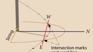
- How the Early Arabs accurately determined the four cardinal directions
- The Arab Windrose or 32 directions
- How the early Arabs measured distance
In this video we want to add some Further Information. Now, before we start we must get ourselves into the mindset of the early Arabs. They did not have a map of the world, they did not even have a map of the Middle East. They did not think in terms of maps, nor in terms of latitude and longitude. Those had not been invented yet or introduced into their world. This is where most modern people face a wall. They cannot imagine a world without thinking of maps. So how can I describe what was in the Arab mind?
First of all, the Arab merchants thought in terms of the Arab Windrose with its 32 distinct directions and 224 points in total. Every place they went to this Arab compass would follow them around. And it was like standing in the middle of the compass.
The Arab knew that to get to a specific destination he would have to walk a certain number of steps. Merchants in Arabia had established the number of steps through countless repeated trips. Those numbers were firmly established.
So in his mind, the Arab merchant thought in terms of connecting windroses, and whenever he walked along the windrose followed him.
Start here and go a certain number of steps in a certain direction. This was aided with what was called ishārāt (local guides). He would know that you reached a certain mountain, or rock formation after so many steps. That mountain or rock formation was a local guide. Along his route, he would know where there were hidden water tanks in the desert. These had been carefully constructed by the Nabataeans over the centuries. The Nabataeans knew where these were.
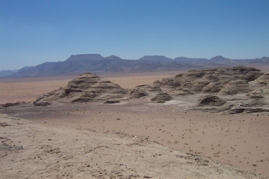
Paran desert south of Edom
Here is a water collection system on the top of this pile of rocks. The small channels or set stones direct water towards one place. Whenever it rains, the small channels direct the rainwater towards a hidden cistern.
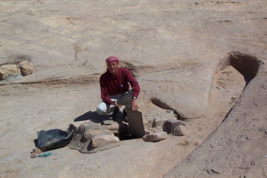
The lid of the bell shaped cistern.
Here is my friend Herb beside the entrance of one of these cisterns. Modern Bedouin have placed a metal lid on it. The rainwater runs under the lid and into a large bell shaped chamber carved out of solid rock. Many of these water cisterns were several stories deep, holding thousands of gallons of water. Long ago the Nabataean merchants learned that the problem in the desert was not lack of rainfall, it was lack of water storage.
But for anyone passing by, the pile of rocks in the desert looked like ‘a pile of rocks.’ They would never imagine that there was water, plenty of water not too far away.
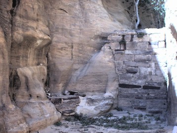
Nabataean water collection dam
Here is a Nabataean dam built across a crack in the side of some rocks. This dam is out of sight of those traveling in the desert. Whenever rain falls, it is collected on the rocks above and channeled to the place behind the dam. At the bottom of the dam there is even a tap which could be opened to obtain the water. Nearby there is graffiti scratched on the rocks.
These water collection systems formed the network of ishārāt or local guides along the way. The merchant caravan masters knew their way from one location to another. So in their minds there were entire networks of windroses.
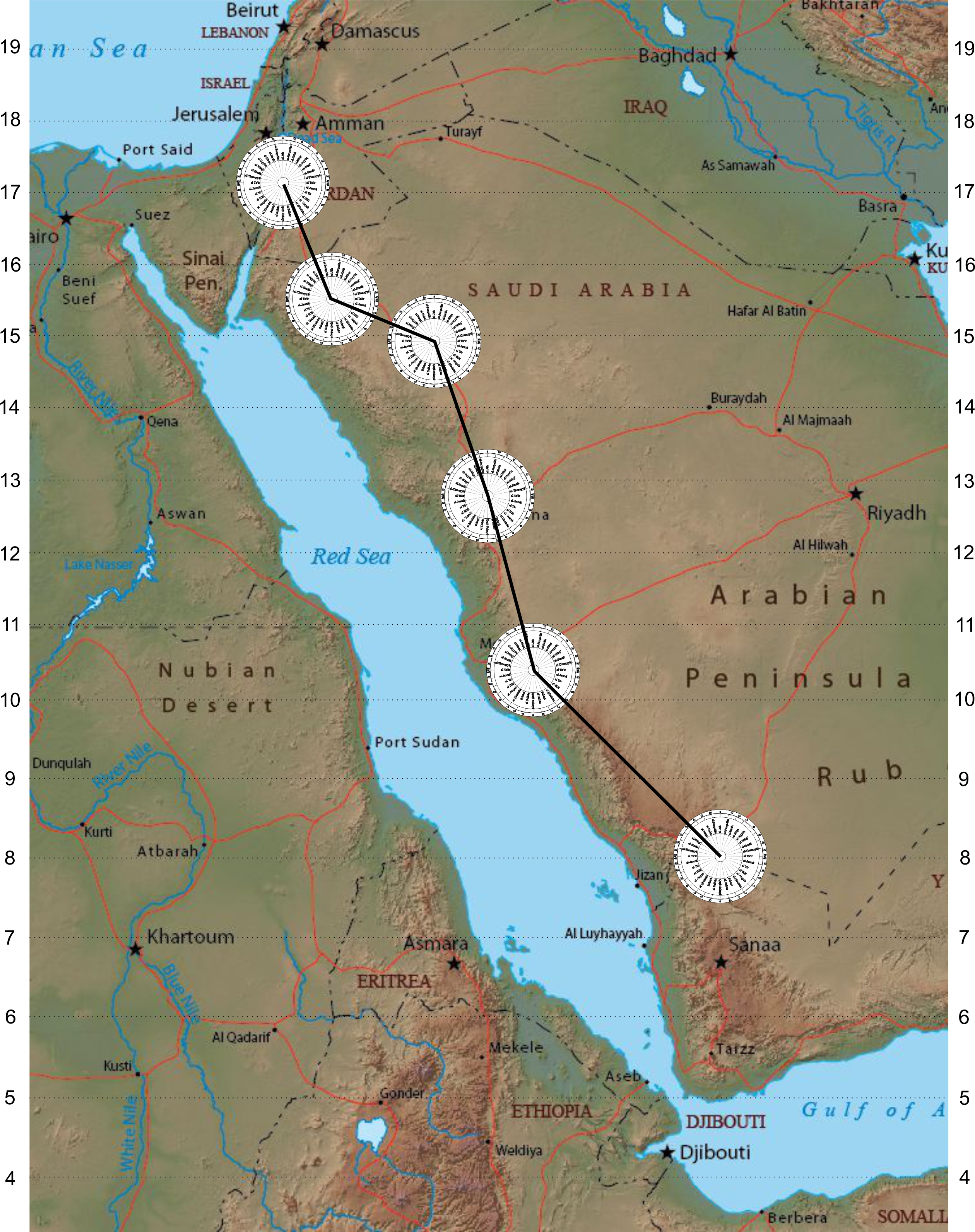
Multiple windroses make up a journey
Now, the one thing the Nabataeans did, was keep their network of water cisterns secret. This ensured their safety, as they could disappear into the desert, and pursuing thieves, bandits or armies could not follow them.
They also kept their navigational knowledge secret. They did not want others cutting into their monopoly on Arabian trade.
But way back in 25 BC, they were their own undoing. Remember this date. Let’s examine the story for a moment.
Way back in 25 BC, the land of Yemen was actually a number of different kingdoms. Here is a rough map of these kingdoms. For sake of our illustration we will limit this to three important kingdoms.
For centuries before this, the Nabataean camel caravans would arrive each year to purchase the Frankincense harvest. Every year like clockwork they appeared out of the desert, arriving at the Sabaean Kingdom. This made the Sabaeans very happy, and they put pressure on the other kingdoms to sell all their incense to through them.
The bulk of the incense was grown in the Hadramout region. From there it was moved INLAND to the Sabaean Kingdom, who then sold it to the Arab caravans. This system worked for centuries. It was the way things were done.
Eventually the Sabaean kingdom took a larger and larger portion of the proceeds, probably in the form of taxes or tariffs.
Something else was also happening. The Nabataeans were growing in their knowledge of the use of boats. Sail Boats. They used a lateen or triangular sail, which allowed their boats a great deal of maneuverability.
The only threat they faced was when the Egyptian navy put military boats on the Red Sea. One clash we know of was when the Ptolemies moved five Egyptian quadriremes into the Red Sea and clashed with the Nabataeans. Egyptian boats used either oars and or square “lug sails.” They were not very effective on the Red Sea where the winds were often contrary to where the ships wanted to go, and the Nabataean Shows could sail away from the slow moving Triremes.
A second event took place in 30 BC when Cleopatra and Antony dragged boats from the Nile to the Red Sea in order to escape to India. The Nabataeans became alarmed, and they sunk the Egyptian boats. Seeing their way of escape cut off for them, it seems Cleopatra and Antony took their own lives.
From this point on, the Nabataeans were sole masters of the Red Sea. So in 25 BC, the date we mentioned earlier, Nabataean boats started appearing off the southern coast of Yemen.
Since the Sabeans were enforcing their taxes and tariffs on frankincense, the Nabataeans started to deal directly with the Hymraite Kingdom. The Hymrarite Yemenies used inflated animal skins to make rafts and float their cargos of incense to a small Island. You can find this story in Agatharchides 87, and cited by Diodorus Siculus Bibliotheca III 42:5 and by Artemidorus in Strabo Geography xvi, 4:18, as well as Patricia Crone in her book Mecca Trade, Spices of Araby, Classical Spice Trade, Page 23.
Wolek suggests that this island was probably Tiran (Woelk, D. 1966: Agatharchides von Knidos. Über das Rote Meer. Übersetzung und Kommentar. Inaugural-Dissertation zur Erlangung der Doktorwürde der Philosophischen Fakultät der Albert-Ludwigs-Universität zu Freiburg i. Br. Bamberg.)
In the end, the Nabataean merchants allied themselves with the Himyarite empire that lay along the southern coast. The other South Arabian kingdoms did not touch the sea but all had capitals and cities that faced inland towards the incense trail. As the caravans grew fewer and fewer the trade switched over to the maritime route. Within a few years the Himyarite Empire grew in strength and power, while the other kingdoms struggled and eventually caved in to Himyarite domination.
Navigation on the water was much different than navigation on land. The boats on the Red Sea relied mostly on measurements of the height of the North Star, as the Red Sea is long and narrow. So most navigators concentrated on the ships sailing across the Indian Ocean.
Once Chinese envoys arrived in Arabia, around 100 AD, Nabataean representatives returned with the envoys to China and thus links between China and Arabia were firmly established. This was around 100 AD. Muhammad would not come onto the scene for another four hundred years, and by that time land-based navigation was a thing of the past, and the skills were only known to a few merchants who still traveled in Arabia.
That is why it is important to remember that Muhammad made merchant trips. We know of at least one trip to Bosra in Syria. It may have been on this trip that Muhammad honed his skills in celestial navigation. It may have been in that trip that Muhammad became fascinated with the skill of writing poetry that contained a fixed number of beats. I believe this is why Muhammad’s earliest compositions started with a series of letters, which represented numbers… giving us the number of beats in the composition. Today these are known as muqatt or the magic numbers in the Qur’an. But that is the topic for another video, sometime in the future as the problem with Muqatt is that as changes and additions were later made to the Qur’an, the Muqatt or number of beats became meaningless. Now I have really gotten off track into another whole theory. So let’s go back to navigation.
One of the problems we face in uncovering and discovering the ancient methods used by the Nabataeans, is that they were very secretive about their methods. And so as far as we know, nothing was written down about how they calculated directions. The earliest we know of are: Aḥmad ibn Tabrūya (or Tabrawiah) and Khawāshir Bin Yūsuf Bin Ṣabā ḥ al-Arīkī (both with Persian names. Al- Arīkī sailed around 400 AH (1009). These two wrote navigational works which were the basis for the Three Lions who wrote about 100 years later. However, the Three Lions were only academics who had no practical experience navigating ships. (15:30) Around this time a number of reference books were being written known as Rahmānī or pilot guides, with the names of ports, and the measurements attached to that port. All of these works were about navigation on the Red Sea, not about the previous methods of navigation on land. These early writers all made references to the land based navigation, but by their time everyone was interested in navigating on the ocean.
So no written records have come down to us. Ibn Majid had access to the Three Lions, and they took their information from the two earlier writers, all of whom were interested in recording how the navigators found their way across the Indian Ocean.
When I began this video series I likened this search to discovering how the pyramids were built. We know they were built, and we know lots about ancient Egyptians, but we lack a couple of key concepts. For instance we do not understand how the Egyptians cut rock. Without that knowledge we cannot reproduce how they built the pyramids.
And so, with the Nabataeans, we are missing a few basic key items that keep us from being to reproduce a workable model of how it was done.
We do know that they could measure the cardinal directions, and fill in all 224 points on the Arab Windrose. We do know that they could measure the distance from one place to another. But how did they calculate angles?
Now, before you get too disappointed, there are simple methods that they could have used early on.
Now I know that some academics have belittled this idea, but I strongly believe that pigeons may have played a role.
All across the Middle East there are what appear to be the remains of ancient pigeon roosts. Pigeons have long been used for long-distance communications. There are records of pigeons being used by the Early Muslims to communicate from both Damascus and Baghdad. Pigeons have the ability to fly back to where their nests. So some pigeons can be taken overland to a distant destination. Then Messages can be attached to their legs, and when let go, the pigeons would fly strait back to their home. This was used as a form of communication was used as late as World War One. We know that the ancient Persians developed the art of training pigeons. One of the earliest records is of the Romans using pigeon messengers to aid their military. Frontinus said that Julius Caesar used pigeons as messengers in his conquest of Gaul. (137 Levi, Wendell, 1977, The Pigeon. Sumter, South Carolina: Levi Publishing Co, Inc.) So the idea of using pigeons is not so improbable.
The Arabs also kept pigeons and used them as messengers. There are records of pigeons being used in Baghdad for mail service soon after the city was built. (138 Blechman, Andrew (2007, Pigeons-The fascinating saga of the world’s most revered and reviled bird. St Lucia, Queensland: University of Queensland Press) Flights as long as 1,800 km (1,100 miles) have been recorded by birds in competitive pigeon racing. This would put all of Syria, Iraq and Iran within flying range of Petra. Their average flying speed over moderate distances is around 140 km/h (86 miles per hour) but speeds of up to 160 km/h (99 miles per hour) have been observed in top racers for short distances.( 139 Walcott, Charles (1996). “Pigeon Homing: Observations, Experiments and Confusions” Journal of Experimental Biology. 199 (Pt 1): 21–27. PMID 9317262. Retrieved 2008-01-04.)
The Forbidden Sanctuary had pigeons. We know this from the writings of al-Ṭabarī: “The horse of one of them began to drop dung and the pigeons of the ḥaram area started to scavenge in the droppings. Al-Husayn reigned back his horse from them and Ibn al-Zubayr said ‘What is the matter with you?” He replied “I am afraid lest my horse kill the pigeons of the sanctuary area.” (140 Ṭabarī Vol. 20, 430, pg 2 )
In personal correspondence with Dr. Richard Holland of the School of Biological Sciences at Bangor University in the UK, he stated that “Some studies suggest they (pigeons) know where to go immediately after release. It is difficult to measure the accuracy of their compass mechanism but the dominant one during the day is the sun compass and this is thought to be very accurate. More recent GPS tracking have shown that with repeated releases from the same place, pigeons recapitulate the route very accurately. The challenge in relying on the release of a single pigeon is that other factors could influence its behavior, and so only by releasing a number of pigeons and assessing their mean heading do we see the pattern that they are oriented towards the home site. A flock released together might be less distracted but I am not sure of any research directly testing this.”
So it is possible that Qiblas were set without any science or math, just by transporting a number of homing pigeons, and releasing them at the site a few at a time until an accurate direction could be established.
So if this is the case, then some of the angles could have been established over time. Remember the early Arab merchants made these trips repeatedly. They would know the direction they needed to go, and along the way they would rely on ishārāt or local guides or identifications to help them. This way they could move from one location to another.
In time more and more routes were added to their knowledge. While this may seem incredible to young people today who rely on their GPS units, it was not too long ago that people knew their way around several cities. In my travels I knew my way around at least a dozen large cities in the Middle East. Because the Arabs had 32 different directions in their mental compass they could give specific directions to others. But how did it all fit together?
So far, I have not come across any book that explains the final steps of how they used the information. We know about the use of the Arab windrose, because it is still in use by some Arab dhow pilots, but they are quickly disappearing because using GPS is so much easier.
We know about the use of counting steps from the Roman records. We know about the use of poetry from a few surviving Bedouin. These old men remembered something of the old days… but I spoke with them years ago.
Under the onslaught of modern technology, the old methods are dying out, and may have already died out. But I still cling to one hope.
All around the world, old Arabic manuscripts are still being found. Perhaps, someday, we will learn the secret of the ancients about how they did navigation.
You see there are collections of ancient manuscripts that have never been carefully examined. There are a quarter million ancient manuscripts in Ethiopia. We don’t even know what they all are. There are thousands of documents from the medieval Sudanese empire of Makuria, written in eight different languages. These come from Qasr Ibrim. Thousands of old manuscripts have survived in West African cities: (Chinguetti, Walata, Oudane, Kano and Agadez)
Despite the many dangers posed by fire, floods, insects, and pillaging, some one million manuscripts have survived from the northern fringes of Guinea and Ghana to the shores of the Mediterranean. National Geographic estimates that 700,000 manuscripts have survived in Timbuktu alone.
Timbuktu was an ancient university town. There were around 60 libraries, which are still owned by local families and institutions. Some of these libraries are being catalogued and a few are being photographed and preserved.
There are four different types of texts there:
- Key texts of Islam, including Qur’ans, Hadiths and Sufi texts
- Works of the Maliki school of Islamic law
- Texts of ‘Islamic sciences’, including grammar, mathematics and astronomy
- Original works from the region, including contracts, commentaries, historical chronologies, poetry, and marginal notes and jottings.
Soon after 1100 CE Timbuktu became a thriving economic center, with a great deal of African gold passing through it. The city was rich in trade of textiles, teach, and even tobacco.
However, the most profitable trade items in Timbuktu were books. Buying them was considered a socially acceptable way of displaying wealth and a great source of prestige. For instance, an old Timbuktu chronicle Tarikh al Fettash reveals that the king bought a great dictionary for the equivalent price of two horses.
There were many different languages in West Africa such as Fulaini, Hausa, and Tuareg, but Arabic was the trade language, and during the 14th century, while plagues killed many in Europe, West Africa became the richest place in the world. (BBC documentary, Millennium: One Thousand Years of History, 1999) The West Africans pursued knowledge, and love to display their collections of books. In time thousands of teachers were attracted to the region, and science and medicine advanced. By the 1500s scribes were employed to copy old books, and the sale of books provided more profit than from any other branch of trade.
At its height, the Sankore University had 25,000 students, many of them also employed in producing textiles so they could pay for their studies.
Today all that remains are the books… thousands of them… many of them unique. John O Hunwick and Alida Jay Boye in their book The Hidden Treasures of Timbuktu (2008) tell us of a letter that was 482 pages long. Many books are held in private collections in private homes. Since so many books have been destroyed by invading armies, or the ravages of the harsh climate, these families are reluctant to reveal what books they have.
If this all comes as a surprise to you, then let’s quickly review a bit of history. I am taking this from the book: Rediscovering the Islamic Classics: How Editors and Print Culture Transformed an Intellectual Tradition by Ahmed El Shamsy (February 2020). Ahmed El Shamsy is associate professor of Islamic thought at the University of Chicago.
In this book, El Shamsy tracks the slow acceptance of moveable type in the Middle East, which was only adopted in the early 19th century. It wasn’t until the second half of the century that the first works of Classical Islam were printed. El Shamsy traces the story of how a handful of editors and intellectuals slowly brought into print what is today the classical canon of Islamic thought. In the 20th century, much of this was done in Cairo although a few other cities such as Beirut Lebanon also played a role.
What is surprising about all of this, is the late dates involved. On my bookshelf I have books from the 1700s and lots from the 1800s. They are not considered really old. The western tradition of printed books goes back several hundred years, so many old books are available to us. The digitization of old books has been going on for decades now, and many of them are freely available on the internet. Plus, individuals, myself included, have digitized many other books for our own private use.
But there are over a million books from Islamic sources that are only now being catalogued, let alone digitized, and very few of them have been studied. Very few young Arabs today are interested in their own history. Please, if you are a native speaker of Arabic, and are looking for a possible career; consider studying history, and especially the many books, manuscripts, and fragments that have not yet been published. (32:38) There are rich resources and your help is needed. In the last few years I have only scratched the surface, and I am optimistic that the answers we are looking for are out there.
So I am still holding out that something more has survived that will tell us of the secrets of early navigation, poetry, and astronomy. If not, then perhaps the secrets of the Nabataean merchants will disappear and be lost to us.
What remains, however, are the Qiblas of ancient buildings, especially the Umayyads, who were early enough to still have among them Arabs who knew the earlier secrets of finding their way across the barren deserts of Arabia, and arriving at a destination that was far beyond the horizon.
I am Dan Gibson, and this has been another video in the series: . How did the early Muslims calculate the Qibla direction?
Page Discussion
Membership is required to comment. Membership is free of charge and available to everyone over the age of 16. Just click SignUp, or make a comment below. You will need a user name and a password. The system will automatically send a code to your email address. It should arrive in a few minutes. Enter the code, and you are finished.
Members who post adverts or use inappropriate language or make disrespectful comments will have their membership removed and be barred from the site. By becoming a member you agree to our Terms of Use and our Privacy, Cookies & Ad Policies. Remember that we will never, under any circumstances, sell or give your email address or private information to anyone unless required by law. Please keep your comments on topic. Thanks!