Click Below to watch the video
How did the Early Muslims calculate the Qibla direction of their mosques? Topics include: Introduction, Challenges, Resource Materials, Finding the four cardinal directions: North, South, East, West. Oops, I just had an error pointed out to me concerning the dates I provided for the Sana’a manuscript. (09:30) which I said had been carbon dated to 570-665 AD. Those are the dates for the Birmingham manuscript. Sorry for giving the wrong manuscript. The Sana’a manuscript upper text is dated by Dr. Puin to the time of al-Walid, 705-715 AD.
Transcript
Hello, I am Dan Gibson, and in this video series we are going to examine the question: How did the Early Muslims calculate the Qibla direction of their mosques? The answer is not going to be easy, because we are faced with a whole series of challenges. Before we rush off and start making suggestions, we need to understand the question we face and the resources we have to draw our conclusions from. Now before I start, let me make an analogy.
In some ways the question we have at hand is similar to the question: How did the ancient Egyptians build the pyramids? This is not a modern question, it has been asked for several thousand years. People looked at the pyramids and asked “How did they do this?”
Now our question is similar but it has a twist.
If we go back and read Islamic mathematicians and astronomers they also asked the question: How did the early Muslims establish their Qiblas? The twist is that by 300 years after Islam started, everyone was convinced that Mecca in Saudi Arabia was the place where all Muslims faced, and had faced since the founding years of Islam. They were told that in the first year and a half after the prophets Muhammad moved to Medina that he faced Jerusalem, and then God revealed some verses in the Qur’an where the direction of prayer was changed to facing Masjid al Harām which every Muslim at that time believe was in Mecca in Saudi Arabia.
When people looked at the confusion of the early Qiblas, they were convinced that early mosques were wildly inaccurate, and they developed reasons why they thought this happened.
Then in 2010 something happened. In the Encyclopedia of Islam, Dr. David King in an article on Mecca and the Qibla noted that a comprehensive survey of the Qibla direction of early mosques had never been carried out. He wrote: No survey has yet been made of the orientation of medieval mosques. Such a survey would be of considerable interest for the history of Islamic architecture as well as the history of science. And so I began my own private survey of the earliest mosques from the founding years of Islam. I was especially interested in the first two centuries of Islam, but I also added some significant mosques from the third century of Islam.
I began with the very first mosques built in Medina: the Prophet’s mosque, the Quba mosque, and the Qiblatain mosque. I discovered over 130 mosques built during the first 200 years of Islam. By that time the way mosques were constructed and the orientation of mosques was solidified. A number of the early mosques could not be used for research, because the original mosques had been torn down and totally rebuilt, obliterating any evidence of the original mosque. But many mosques and places of prayer survived, and we can examine the original foundations.
From my survey it became apparent that there were four different options that Muslims used when orienting their mosques. As I point out in the documentary film “*The Sacred City*” the earliest mosques seem to face the city of Petra in Jordan. In my books Qur’anic Geography and Early Islamic Qiblas, I present fifty further arguments from history, Islamic literature and other sources that support this idea.
However, 109 years after the founding of Islam, the first mosque was built facing Mecca in Saudi Arabia. I searched everywhere for an earlier mosque, but I could not find any conclusive evidence that a mosque was built facing Mecca in Saudi Arabia during the first 100 years of Islam. They all faced the city of Petra.
Something happened around 100 after the founding of Islam. Not only did Mecca become an option for the Qibla, but General Ḥajjāj, who wielded great influence under several caliphs, faced his mosque towards the middle of Arabia. He named the first mosque with this new Qibla or orientation the Wasit, or the Between mosque. Over 20 mosques were built during the lifetime of Ḥajjāj that used this Qibla.
At the same time, something happened in North Africa. There was a lot of friction between the military leaders in North Africa and the caliphs in Damascus. It all started with General Abū al-Muhājir Dīnār who during his time of frustration with the Caliphs who were far away in Damascus, he oriented his new mosque towards somewhere in South Africa.
This was the beginning of the eventual break between North African Islam and that of the caliphs. I have called this new mosque orientation the Parallel Qibla, because this Qibla is parallel to a line drawn between Petra and Mecca. And I have presented many arguments for these four Qiblas in YouTube videos and in papers and articles on the website Nabataea.net As you can imagine, many Muslims were unhappy with my conclusions.
But interestingly enough, I have heard from more Muslims who are supportive, than those who disagree with me. Maybe those who disagree never email but make their comments somewhere else. I don’t know. But I do know a few have disagreed, and some have tried to argue with various mosques and I have found this helpful to make me double check my information to make sure it is accurate. Because of an argument, I have even had to come up with a number of corrections I had to make. So thank you to those who have challenged me.
One of the early arguments used by Medieval Muslims is that these were erratic directions of prayer. They simply concluded that the early Muslims lacked the ability to correctly orient their mosques to Mecca in Saudi Arabia. Therefore they conclude that the Muslims between 600 AD and 800 AD lacked the ability to establish an accurate Qibla. And so the challenge is for me to prove that they could establish accurate Qiblas.
My principle argument here is the mosques of the first two centuries of Islam. It is immediately obvious that the vast majority of mosques faced one of these four Qiblas. Not only do statistical studies support this, but they demonstrate that the average qibla was accurate to within three to four degrees.
Those who support the various random theories refuse to accept this and they say, no it was just all random.
So in this series of videos I want to explain some of the techniques that early Muslims had available to them when they were orienting their mosques.
In this video we will examine how the cardinal directions were determined. That is North, South East and West. Could they determine cardinal directions within a degree or two?
Resource Materials
Where can we find the information that we need? First I must acknowledge that we are missing some of the key evidence that we need. Sadly for us, just like the building of the pyramids, there is little or nothing available from the time period in question. Most of the mosques we are dealing with were built between 626 -726 AD (5 - 107 AH). We have no Islamic literary sources from this time period; none what-so-ever. Not a single Islamic book or manuscript exists from this time period except some Qur’anic manuscripts, most of which are incomplete.
For example, the Sana’ā palimpsests have been carbon dated to sometime between 570-665 AD. Remember, carbon dating always gives us a range of dates. You cannot arbitrarily choose one end of the spectrum or the other. The most accurate is the middle date, give or take, in this case, fifty years on either side.
Remember, those dates provide us information about when the animal was killed. After that the skins were dried, cured, treated, and then were available for writing on. How long they hung before someone bought them and used them for writing materials is anyone’s guess. It is possible today to obtain skins that are hundreds of years old, and still use them for writing on. Thats how forgeries are made. So even with carbon dating, it is possible that the animal was killed in 570, but it is also possible that the animal was killed in 665, a hundred years later, and it is possible that the skin hung in the back of a shop for several decades before being used. So the Sana’ā palimpsest manuscripts could be as late as 700 AD.
Another date to remember is that the Sana’ā mosque wasn’t built until 705 AD. Sometime after that period, the order was given that old Qur’ans were to be gathered up and destroyed. It appears that and someone couldn’t bear to destroy them and so in the Sana’ā mosque they stuck them up in a crevice in the mosque which was eventually plastered over. Remember Ḥajjāj didn’t start building his Between mosques until this time, so it may have been during Ḥajjāj’s time that pressure was put on people to disregard old Qur’ans and accept Ḥajjāj’s newly updated Qur’ans. So dating the gathering and destruction of Qur’an is not exact, because it appears to have happened several times in early Islamic history. Now we must not get sidetracked with this issue. Needless to say, while the Qur’an existed in some format, we have no other Islamic written material from this time period.
Now, we cannot say that we have nothing written from this time period, because we do have graffiti, as well as some normal written items, such as bills, tax receipts, some letters and other items. But they are very few and very scattered. But we have no books from this time period, especially anything that tells us how the Qibla direction was determined.
So what sources of information can we use?
- What do later Islamic sources tell us? How much later are they? Are they guessing or do they know for sure that their information is correct?n Some people prefer to turn to the medieval mathematicians but I prefer to turn to the medieval navigators. They have some very interesting information and that is what we are going to look at in this series.
- What does archeology tell us? While we don’t have book manuscripts, we do have the mosques foundations in question. What can we learn from the mosque data? Not only mosques, but also Umayyad buildings such as Qasrs.
- What do non-Islamic sources tell us? Before, during and after this period. For instance, if the Nabataeans developed their knowledge of Navigation several centuries previous to the founding of Islam, what can we learn from the histories of the Egyptians, Greeks, Romans, and Persians, who wrote about the Nabataeans or even from India or China? Can they tell us anything about the Arabs and how they navigated?
- What was common knowledge, known generally to people up to this time?
- Was there specific knowledge that the Arab Nabataeans knew? How advanced was their science of navigation? How far had they traveled?
- Was there an attempt on behalf of the Nabataeans to deliberately hide their knowledge and keep it secret? As you would in a guild? Perhaps those who built mosques or chose Qiblas we a special guild?
There are lots of questions, and so it is important for us to understand the larger picture as we tackle the specifics of Nabataean navigation. So the first issue I want to deal with is: Could the Arabs at the time of the founding of Islam accurately determine the four cardinal directions? North, South, East and West.
Several people have written me and have asked about the magnetic north pole. Since the magnetic north pole has shifted over the years, would that not have affected the Qibla direction?
This question assumes that the Arabs setting the Qibla used a magnetic compass to find the North Pole. However, from history we learn that compasses were not generally known in the Middle East until 680 AH, or around 1200 AD. The mosques built during the first 100 years of Islamic history were built hundreds of years before this. 5 - 107 AH or 626 -726 AD. Since the magnetic compass was basically unknown at this time, except perhaps by some specialists, the shifting magnetic North Pole did not play a role in finding the Qibla direction.
So how did they find true north, and how accurately could the ancients establish North and South? Could they get it right on, or would they be off a couple of degrees? If they were off on the cardinal directions then that would probably affect all their other calculations as other measurements rely on first establishing true north.
Let’s start with the exact method. It was used by Egyptian, Greek and Roman builders. For instance, when buildings the Great Pyramid in Egypt, the buildings oriented the pyramid so that the four corners faced north, south, east and west. It is so close that it is only 0.067 degrees off. How did they do it? This was several thousand years earlier than the first Muslims.
Historians have suggested several solutions, but the simplest can be illustrated with a stick stuck in the ground.
There are two papers that should be read. There are two papers that should be read on this topic. The first is by Martin Isler ‘*An Ancient Method of Finding and Extending Direction*’, (1989), JARCE 26, pp. 191-206. Martin presents a method of finding the cardinal directions using nothing less than a stick and some string, and some time. This method has been used by hikers, hunters and explorers for many years.
The second paper adds something to what Martin Isler describes in the first paper. That paper is: Occam’s Egyptian razor: the equinox and the alignment of the pyramids, by Glen Dash, The Journal of Ancient Egyptian Architecture, Vol 2, 2017 ISSN 2472, Now Glen Dash presents several methods but let’s look at the ancient method described by Martin Isler.
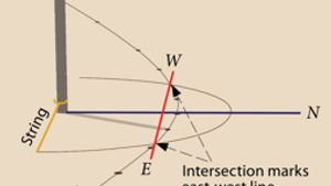
The building architect would put a straight pole in the ground and start marking the end of the shadow as it moves across the ground. Once some points have been marked on the ground, the architect takes a string and ties it to the stick, making a circle. The two places where it intersects marks east and west. Thanks to the Journal of Ancient Egyptian Architecture for this illustration.
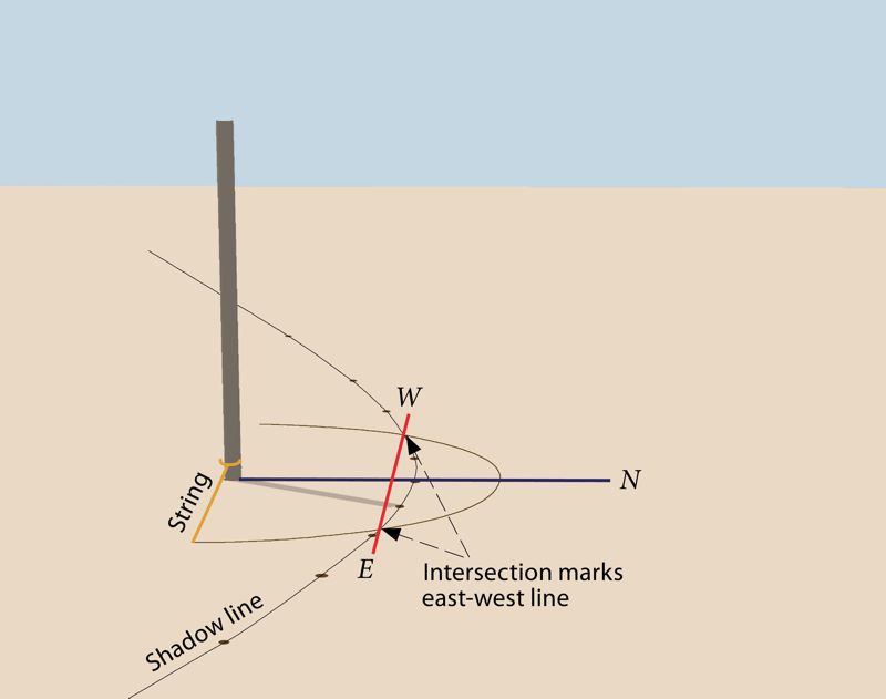
Using shadows to find the cardinal directions
A simpler method could be used, but only on the days of the equinox. Here the shadow makes a straight line very near north and south. Thanks to Wilma Wetterstrom for this illustration.
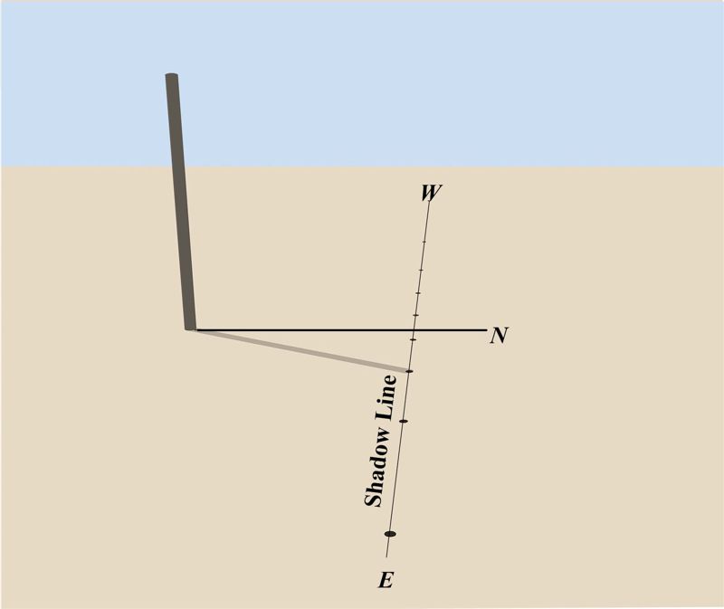
Using shadows to find the cardinal directions
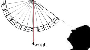
Architects could then draw two circles, which would provide an accurate 90 degree angle. It is believed that Egyptians used this method since the Old Kingdom period in Egypt (third millennium BC.)
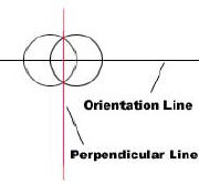
Finding a right angle
Now one more thing, once they had a line that marked true East and West, they needed an accurate right angle. This was done using two circles. They would have made two identical circles by choosing two points on the east west line. The intersection of the two circles would then provide a right angle. Some doubt this method was used because the elasticity of the string or rope used to sketch the circles would lead to inaccuracies. However, at Khufu’s pyramid, there are a number of post holes dug that might have been used to draw such circles, so the method cannot be ruled out. Furthermore, the Egyptian may have used a rod or some other device rather than a rope or string to draw the circles, eliminating elasticity. Egyptian records are filled with people using rods, not string for measurement.
So here in this first video we have demonstrated that using very simple instruments, some wooden rods and some strong non-stretching string or woven material architects could mark out the four Cardinal directions, north, south east and west.
This is why I found it very strange that some historians, like Dr. David King and others suggested that the ancient Roman city was laid out according to cardinal lines… such as Roman Cordoba. While this is approximately true the Romans had the ability to be much more accurate. If they were aiming at true east and west, they could have done a much better job. They had the tools and they had the knowledge to be very accurate.
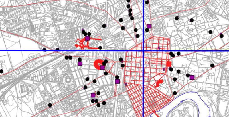
Street map of ancient Cordoba
The fact that parts of the city are approximately east and west tells us that orientation to the cardinal directions was not that important to the Romans. Perhaps they had other things in mind. They could have been much more accurate.
So I hope I have demonstrated to you that the Arab architects could accurately find the four cardinal points. If they wanted to align buildings North, South, East or West, they could do it very accurately.
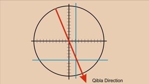
The fact the vast majority of Qibla directions are not close to the four cardinal directions illustrates to me that something else was going.
In the next video, we want to examine the Arab compass with its 224 degrees, and how it was used.
I am Dan Gibson, and this has been the first video in the series about Arab Navigation.

Page Discussion
Membership is required to comment. Membership is free of charge and available to everyone over the age of 16. Just click SignUp, or make a comment below. You will need a user name and a password. The system will automatically send a code to your email address. It should arrive in a few minutes. Enter the code, and you are finished.
Members who post adverts or use inappropriate language or make disrespectful comments will have their membership removed and be barred from the site. By becoming a member you agree to our Terms of Use and our Privacy, Cookies & Ad Policies. Remember that we will never, under any circumstances, sell or give your email address or private information to anyone unless required by law. Please keep your comments on topic. Thanks!