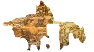
The Madaba Map was found in 1884 in an old Byzantine church, now named The Church of the Map. The local Christians had decided to build the present Greek Orthodox Church of St. George, which is now located beside the ancient church. The map is dated to the sixth century, during the time of Emperor Justinian (527 - 565). It is the oldest known map of Palestine and is the source of some fascinating historical data. It has survived, despite damage over the years by fire and the collapse of the original church. The church faces east, so the map places the viewer in the Mediterranean Sea looking east at the Holy Land. In the center of the map is the Dead Sea with the Jordan River running into it on the left. On the right is the Nile River.

undefined


Page Discussion
Membership is required to comment. Membership is free of charge and available to everyone over the age of 16. Just click SignUp, or make a comment below. You will need a user name and a password. The system will automatically send a code to your email address. It should arrive in a few minutes. Enter the code, and you are finished.
Members who post adverts or use inappropriate language or make disrespectful comments will have their membership removed and be barred from the site. By becoming a member you agree to our Terms of Use and our Privacy, Cookies & Ad Policies. Remember that we will never, under any circumstances, sell or give your email address or private information to anyone unless required by law. Please keep your comments on topic. Thanks!