Originally titled “The Land of Eden Located” 1964
by David J. Gibson
David J. Gibson spent many years searching for the Garden of Eden. As a Bible believing Christian he was convinced that Eden was an actual place, and that the Bible provides us clues as to its location. David’s search for Eden was cut short in 1964 by his untimely death. However, before he died David was able to complete the initial draft manuscript of a book titled. “The Land of Eden Located.”
__
David’s son, Dan Gibson spent many years living in the Middle East and researching the history of the ancient Nabataean civilization. In 2003 Dan decided to scan his father’s book onto the computer, typeset it and add the graphics to the appropriate places. He then edited a number of places where small corrections needed to be made, or where updated information is now available, (including the use of satellite images.) Now this updated manuscript is available on the internet for all to read. We trust you will enjoy this book and the years of research that went into it.
Chapter One: A Few Leading Clues
For many years theologians, historians, and scientific thinkers have disputed about the story of the Garden of Eden. Is it actual and historical? Is it allegorical or a myth? Or is it just plain fantasy? That it may have allegorical meaning, we will not deny. But one thing we do wish to point out is that, taken at face value, treated as if historical, some really astonishing things begin to come to light.
We begin to discover a strange alliance to certain actual facts which the new science of archaeology is unearthing, a fitting together of known facts; so much so that even the doubter is made to stop and wonder if some reality does not lie behind the ancient story. The Biblical account and description of Eden, rightly and fairly treated, not only makes sense with itself but harmonizes astonishingly well with the geography of ancient times. That this should be so, we think, lends support to ‘The historical view” though others may dissent. Nevertheless, let us set forth our findings for what they are worth, hoping that others will pick up the good points therein and make further research.
Our study of this interesting subject falls into three main sections:
(1) Eden in Relation to Geography
(2) Eden in Relation to Geology
(3) Eden in Relation to Chronology (both Biblical and Secular systems of dating)
That these subjects simply bristle with difficulties we know only too well, but we believe that what we have to say will remove at 1east some of them and will assist in establishing a good foundation for future study.
A Geographical Description
At the outset of this study of Eden in relation to geography may we point out that the Hebrew account recorded in chapter 2 of Genesis is, for Biblical literature, an unusually full and detailed geographical description. It abounds with geographical names. The writer is putting forth special effort to locate and identify the geographica1 features referred to. Such trouble and care is surely unnecessary for the purpose of pure fantasy or allegory. Clearly the writer had in mind a definite locality which he expected his readers to recognize through the detailed description given. Regardless of whether one accepts the whole Eden story or not, still we cannot do otherwise than recognize that the writer had a specific spot in mind when he wrote this story. That spot was an actual place to the orthodox scholar the place where a real event occurred; to the liberal the place which the mythical events are depicted as taking place. In either case we are concerned with locating that actual place.
The Lord Jesus Christ and the New Testament writers always treat the Genesis account of Eden as historical. This alone is final and sufficient authority for a large number of people. However, it will do no harm to enquire into the story itself for self-evidence of actuality and historical genuineness.
The text itself runs as follows, each sentence and section dea1ing with specific places and things.
The Garden
And the Lord God planted a garden eastward in Eden; and there he put the man whom he had formed. And out of the ground made the Lord God to grow every tree that is pleasant to the sight, and good for food; the tree of life also in the midst of the garden, and the tree of knowledge of good and evil.
The River of Eden
And a river went out of Eden to water the garden; and from thence it was parted, and became into four heads. The name of the first is Pison: that is it which compasseth the whole land of Havilah, where there is gold; and the gold of that land is good: there is bdellium and the onyx stone. And the name of the second river is Gihon:the same is it that compasseth the whole land of Ethiopia. And the name of the third river is Hiddekel: that is it which goeth to the east of Assyria. And the fourth river is Euphrates. –Genesis 2:8-14.
Clue No. 1. Postdiluvian Names are Used
Now the foregoing passage presents us with a most interesting list of names. Considering the antiquity of this description it should fill any normal imagination with excitement. If a similar description were dug up on a clay tablet written 1400 B.C., would any archaeologist rest content until he located the spot? The passage gives us these names:
Eden a Babylonian name we will study later
A Garden lying eastward in Eden
A River unnamed, coming out of Eden, through the garden
Pison a river head linked with Havilah
Havilah a land or district
Gihon river linked with Ethiopia
Ethiopia Cush (in Hebrew); a land or district
Hiddekel a river linked with Assyria
Assyria (Asshur in Hebrew); not called “a land”
Euphrates a river, not further identified
One glance at the known place-names in this list strikes us at once with an important factor. They appear to be names used in later history, definitely postdiluvian names, not antediluvian names, as evidenced by the Biblical record itself. They are names which came into use only after the Flood. The importance of this can scarcely be over-emphasized. “Assyria,” (Hebrew, “Asshur”) is a name which the Hebrews understood to derive from Asshur a son of Shem born after the Flood (Gen.1O:22). Therefore, in the Hebrew concept the name simply did not exist before the Flood. The same is true of others. “Havilah” is a postdiluvial name (Gen.l0:29); so is “Ethiopia’” (“Cush”), (Gen.l0:6). This proves conclusively that the writer was using names in current use known and recognized geographically at the time he was writing. In short, he quite expected his readers to be able to identify the locality by his description. It follows that the place was real at least. We are, at the moment, concerned with finding that place which the writer had in mind. But let us keep firmly in mind the essential factor that we are dealing with place-names in current use at the time Genesis was written.
Clue No.2. Eden was in Babylonia
There have been some fantastic suggestions put forth as to the location of the land of Eden. One placed it on a map nearly on top of Mount Ararat. He showed a little river starting out eastward, then dividing most abnormally and unnaturally into four rivers. One circled around his Eden on its north, west, and south sides successively and became the Euphrates. Another branched southerly and became the Tigris. Another, labeled ‘Pison’, struck off easterly over miles of territory and ended up as the Ganges in India. The last, named ‘Gihon”, went off south-easterly, and after making a huge circle through what is now Iran, the Indian Ocean, the Gulf of Aden, and Ethiopia it finally ended up as the Nile flowing through Egypt and emptying into the Mediterranean. To relieve the difficulty of this river flowing through the Indian Ocean, that Ocean was neatly wiped off the map so that dry land appeared. As the Euphrates and the Tigris still needed a Persian Gulf into which to empty, the same was cut off from the Indian Ocean and made into an inland sea. The same was done with the Red Sea. Such juggling with maps does not help matters and only makes the straightforward Biblical story seem incredible and ludicrous. We feel such interpretations must be based upon some major flaw in understanding the text.
The people who lived in the day when Genesis was written were not such ignoramuses as to think the Euphrates and the Nile had a common source or were anywhere connected. If they were aware of the Ganges River at all, they would be stupid beyond comprehension to imagine it somewhere linked on to the Tigris which they were acquainted with from source to mouth.
Should anyone suggest that perhaps great changes in land and ocean configuration occurred during the Flood, let me remind you that the writer of Genesis uses the present tense when dealing with the four rivers, and he wrote after the flood. He ‘vas writing of the four rivers as they were in his day – they were still in existence. That being so, then the land configuration had not changed to that extent during the flood.
Now as to the general whereabouts of Eden, Dr. George A. Barton in ‘Archaeology and the Bible’ (p.541, IVth ed., 1925, published by American Sunday School Union, Philadelphia), notes that Ezekiel uses the name as belonging to an actual locality existing in his day. When listing the countries which traded with the city of ‘Tyre, Ezekiel names “Eden” as one of them. Dr. Barton says: “Ezekiel seems to have called southern Babylonia Eden. In ch. 27:23, in enumerating the places that had traded with Tyre, he begins at Haran, then mentions Canneh (a corruption of Calneh of Gen.10:10 identified by the Talmud with Nippur), Eden, and the traffickers of Sheba. He places Eden “in the series exactly where southern Babylonia lies.” This is a clue from Scripture itself where to start looking for the Land of Eden.
Constructing a “Treasure Map”
When the writer was a boy he frequently visited a part of the Atlantic coast of North America, where the famous pirate Captain Kidd was reputed to have landed and to have buried some of his vast treasures. Naturally, myself and other youngsters had our imaginations fired by the hope of accidentally stumbling upon his treasure. We would willingly have dug deep into the sand or earth if we had had but a slight clue as to where to dig. We looked around the place where he was said to have landed, and tried to determine what would be a likely choice as the spot at which he wol1ld bury a treasure, but without success.
Now we have something we want to find. We want to find out just where the Land of Eden was in Adam’s day. We youngsters never had a treasure map to help us find Captain Kidd’s hidden hoard. If had only had such, how we would have studied it! We would have had no rest until we had mastered its details and set out to discover the exact spot. Such is the enthusiasm of even the young for this world’s wealth! But here in the Scriptures we are given a meticulous and careful description of the location of the Land of Eden. God did not give that unusual and detailed description without purpose. I am sure He wanted us to be able to find that location – otherwise He wasted words to no purpose, and that is not like God. No, we may rest assured He intended us to be able to locate from this description just where man’s original home really was, the place where our first parent’s which lived in innocence until the first sin entered and man fell; after which he needed a Saviour, the promised “seed of the woman.”
So precise and exact is the description of the rivers of Eden that we feel it is possible to pick up the details from the Scripture text and begin to place them on paper. This should assist us greatly. Therefore, with the locating of Eden as a “treasure” we want to find, let us start drawing a theoretical “treasure map” to assist us in our hunt. These sketches are based on a step-by…step solution to the Eden question which the writer submitted to the late Dr. William Bell Dawson of Montreal years ago. It is an attempt to explain the text simply, and without any geographical changes other than what are natural and scientifically recognized or at least acceptable in our present state of knowledge. Dr. Dawson immediately pronounced it the best approach to this subject he had seen. Some improvement has been made in these sketches and maps, as new light has come in, but basically the approach is the same.
Notice then, the first geographical feature given.
“And the Lord God planted a garden eastward in Eden.” Genesis 2:8
Only two points are given us here:
\ (1) Eden, which appears to be a district or area; and
\ (2) a garden situated in the easterly portion of Eden.
Take a sheet of paper and draw on it a fair sized circle. Then print in it the word “Eden.” We do not know what shape Eden was, but this circle will represent the region to us until we can add sufficient details to do away with the fixed, exact circle.

Circle with Eden written in it.
Now the text informs us the garden was “eastward in Eden.” The top of your paper will be north, so the easterly side will be the right side. Draw a smaller circle inside the larger circle, but close to the right side. Mark this “the Garden.” We now have the Land of Eden and the Garden placed on our treasure map.
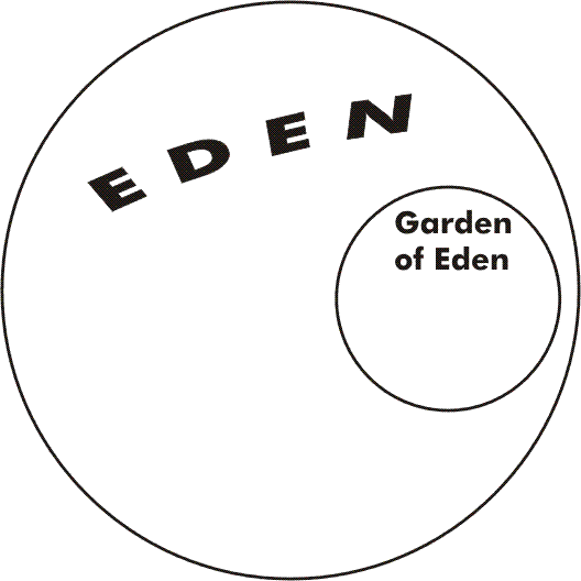
The Garden added to the circle
The next geographical feature found in our text reads: “And a river went out of Eden to water the garden.” Genesis 2:10.
To show this river on our “treasure map”, draw a wavy line from the center of our larger circle, which represents Eden, making the line run easterly through the middle of the smaller circle which stands for the garden, and continue the wavy line far enough easterly to just pass outside the boundary of Eden, for the text states the river “went out of Eden.” This river is not named in the text but for the sake of clarity and simplicity will hereafter call it, “The River of Eden.”
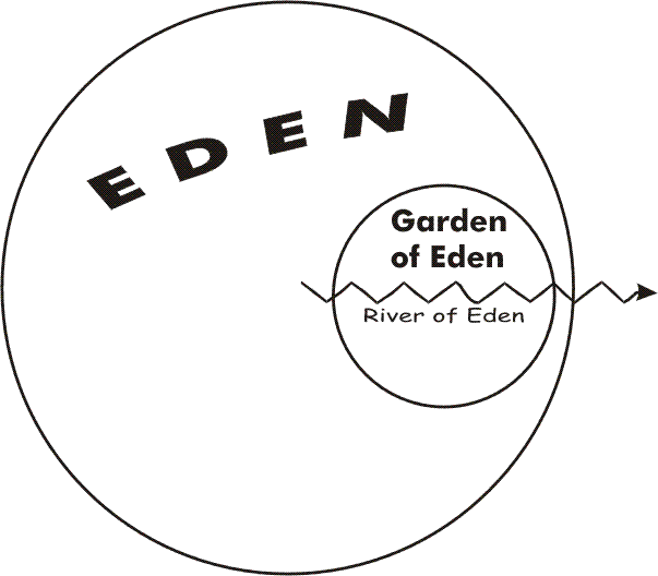
The river running through the garden
The next step in the description is of great importance. We feel it is at this point that so many other attempts at explanation have failed. Note the words of the text carefully.
“And from thence it was parted, and became into four heads.” Genesis 2:10.
So many have taken this to mean that the river divided and became four rivers, like the dividing of a river at its delta, that it is difficult to shake the idea, although it always lands the expounder into difficulties. But stop and consider. Such an explanation makes four rivers with but one head, and that is definitely not what the text states. The text explicitly uses the terms, “a river’ (singular) having “four heads.”
Four rivers with but one head would be a most unnatural phenomena. There are, indeed, a very few Cases of a stream or river dividing and not re-uniting aside from delta formations. One such is on the Great Divide or height of land between the Provinces of Alberta and British Columbia in western Canada. Here a little stream divides into two; one branch goes down the eastern watershed to Atlantic waters, the other down the western watershed to end in the Pacific. These two streams have only one head. For one river to split into four, is, I believe, absolutely unknown anywhere in the world, though if such a case were found, it would still be a case of four rivers with one head, and thus could not be a parallel to our text. Thus we must turn back to the text to seek a different explanation.
The solution, we believe, hinges upon the significance of the word, “thence.” From thence it was parted. What did the writer mean by, “thence”? It seems to me that the ancient author has, in thought, placed himself within the beauteous garden he was describing. He has noted that the beneficial river went out of Eden to water this garden.
Where did this lovely river come from? He looks upstream from his position in the Garden. “From thence,” he says, that is, from Eden, from the only place so far definitely named in the text, from “thence” it was parted into four “heads. His eye has looked upstream and has discerned in a masterly way the four main sources of this Edenic river.
Once a person has grasped this upstream look, at once the text begins to make common sense. One river with four heads is sensible, it is a common sort of fact all us; but four rivers with one head is contrary to the facts of geography.
Now if we are correct in the foregoing explanation, then we should find that this explanation should lead to further discovery harmonious facts. To test this out let us immediately transfer our explanation of four heads making one river onto our diagram.
Now our diagram shows “four heads” and “one” river of Eden in a way that begins to look more like reality. By means of these few leading clues we have gained the start of our “treasure map.” In the next chapter we will begin examining the four river-heads.
Chapter Two: The Rivers Euphrates and Hiddekel
In our first chapter we noted a most important and significant fact, namely that the writer of Genesis was using recognized geographical names of his day in his description of Eden. If we ask just when this writer lived we meet varying replies. Those accepting the Mosaic authorship say he lived about 1500 or 1400 B.C. Others argue for a later date, perhaps 700 B.C. While we are amongst those who hold to the Mosaic authorship, let us, in examining the names of the four river-heads and the names of the countries affiliated therewith, consider names in use during the whole interval from 1500 B.C. or earlier down to 700 B.C., and, where necessary, trace them down to modern times.
In examining the four river-heads we feel we will make the best progress by taking the last first. We do this because there is less question or doubt about the last one. The text simply states:
“And the fourth river is Euphrates.” Genesis 2:14.
There is no describing this river. No effort to tell the reader where it is. The writer knew all his readers would immediately recognize this river definitely by its name alone. And so it is to this very day. Everyone knows which river this is.
The River Euphrates
As archaeologists have dug into the ruins of the cities of Babylonia they have unearthed thousands of clay tablets in the cuneiform script. Great libraries have been unearthed and from these writings have come a tremendous wealth of knowledge. We know now that a very brilliant race, the Sumerians, lived there in earliest times. A part of Babylonia was called Sumer after their name, and this word “Sumer” when taken over into the Hebrew, and then transliterated into English appears as, “Shinar.” The Sumerians appear to be related to the Chinese, Mongolians, and Basques by their language.
Before 3,000 BC the Sumerians called the Euphrates “Puranum” meaning, “Great water;” sometimes they called it “Pura,” that is, “water.” The Semitic people, including the Hebrews, called it “Purat.” The Persians altered the “p” to “ph” or “f”, and added an initial vowel, making it, “Ufratu.” To the Greeks this became, “Euphrates.” The Arabs today still call it “Furat.” For over 5,000 years this important river has kept actually to one name, varying only in pronunciation from language to language.
Of the fourth river we feel there can be no doubt. Somewhere along that river, between its source and mouth, lay the Land of Eden.
The River Hiddekel
“The name of the third river is Hiddekel: that is it which goeth to the east of Assyria.” Genesis 2:14.
The third river-head is almost as easy to identify as the fourth. While not everyone reading English will immediately recognize the name “Hiddekel,‘yet scholars are quite in agreement about it. It is the modern “Tigris.”
Those ancient Sumerians called the Tigris, “Idikna” or “Idikla.” The early Semitic people called it, “Idiklat” (in Hebrew,“Hiddekel,”), later shortened to “Diklat.” The Persians pronounced it, “Tigra,” from whence the classical Greek name came, “Tigris.” Today, in
Arabic it is, “Dijla.”
Once again, these are but variants of one name retained throughout all history. This identification is upon firm ground. To make the identification doubly sure, the Tigris is definitely the river of Assyria. The Assyrian capital city Nineveh stood upon that river’s banks.
We now have two of the four river-heads positively identified. This is 50% success in this phase of our search for the real location of the Land of Eden. It brings us to an important point, as we can now begin to check our “treasure map” with reality. To do this, let us take our “treasure map” and place the names Euphrates and Tigris on the two central river-heads.
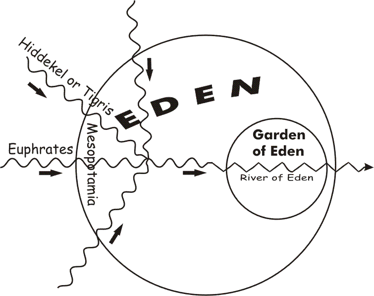
Map of Eden with two rivers named
A person might try placing these two names on the upper or northerly two river-heads, or on the lower, southerly two river-heads, but in either case such placing of the names would soon have to be abandoned in the light of what follows in the next two chapters. We are thus anticipating a little by placing these two names immediately upon the central river-heads.
As we shall presently see, Havilah lies to the south of the two central river-heads, while Cush is to the north, which drives the two identifications we are now sure of (Euphrates and Tigris) toward the center of our “treasure-map.”
These two names on our “treasure-map” may be considered as only tentative for the moment. However, we believe the next two chapters will make the placing very certain.
We ask you now to compare our “treasure map” with any map of the Euphrates and Tigris rivers.
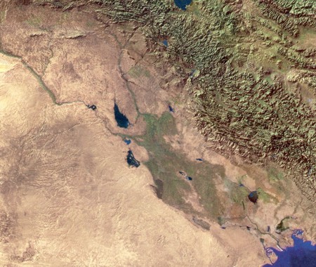
Satellite Image of the Euphrates and Tigris Rivers. They do not meet in the green area, but flow to either side of it, meeting only in the delta.
The land between the two central river-heads compares with Mesopotamia, “the land between the rivers,” as the name means. It takes but a slight clockwise turn of our “treasure map” to bring the central rivers into approximation with the actual relative positions of the Euphrates and Tigris. Surely this is evidence we are on the right track in our search! Thus encouraged we turn now to the text and will study the first named river-head.
Chapter Three: The River Pison
This river receives a rather fuller treatment at the hand of the author of Genesis, than the other three, possibly because he knew it to be harder to identify, even in his day. The text reads as follows.
“The name of the first is Pison: that is it which compasseth the whole land of Havilah, where there is gold; and the gold of that land is good: there is bdellium and the onyx stone.” Genesis 2:11-12.
Clearly, to identify this river we need to know the location of the Land of Havilah. Where, then, was Havilah? Some Bible dictionaries seem hesitant and confused over this name, but all most references to it with Arabia.
Dr. George A. Barton in “Archaeology and the Bible” (See the passage previously quoted) suggests that Havilah stands for Arabia, evidently, Arabia in general. It may be doubted if most scholars would subscribe to this idea. In view of the fact that in Genesis 10:29 Havilah is but one of the many Joktanean tribes of Arabia, it does not appear too likely that the one name would come to represent the whole.
We would rather concur in the view that the old name Havilah is to be traced down to the modern name, “Ha ‘ill”, used of a place in the central part of Northern Arabia. There are a number of wadis or dry river beds running from near that general area north-easterly towards the lower Euphrates. In view of one head of the river of Eden on our “treasure map’ being indicated in this region, we wish to suggest that it is possible one of these wadies may be the River Pison. The question will very naturally be asked, “Would a river bed or wadi be listed by an intelligent writer as one of the four main river-heads of the river of Eden?” To many our proposal may at first seem bold, and in danger of making our position very weak. (See “Atlas of the Historical Geography of the Holy Land,” edited by George Adam Smith, D.D., LL.D., Litt. D., etc., 1915 Hodder & Stoughton, Warwick Square, London, E.C., on page xiii under, “Notes to Maps, “with Havilah (Hawilah) cp Ha’il in Central Arabia.” Some maps give the modern name as, “Hayil.”)
The Drying Up of Arabia
In reply we must again remind the questioner of the fact we are dealing with a very old text which speaks of things as they were in the writer’s day (and before), not as they are in our day. Are we sure there were no rivers there in the past? The present dry wadis were formed long ago in the past by water-action. Some of this action is doubtless by annual streams and the sudden gushes from the exreme1y rare thunder storms which today occur, but there is evidence of a one time greater water abundance in the Arabian Desert than is the case now. It appears that a great, broad, long belt on the earth’s surface, embracing both the Sahara and the Arabian Deserts, has dried up tremendous1y since early times.
The Sahara Desert is still growing and spreading. “About 3,500 years ago,” writes Prof. H. A. Winckler in The Illustrated London News, (Dec. 26, 1936, p. 1173), “the desert ~ between the Red Sea and Upper Egypt was well watered enough to support large herds of wild cattle;” and earlier still, “even the elephant walked in the wadis (river valleys) now dried up. And with these animals lived men. In the shadow of rock shelters along old tracks and around wells they hammered out of the soft sandstone pictures of the game they hunted, their cattle and themse1ves… The main desert was a steppe, and the border near the Nile like a jungle. The Arabian Desert appears to also have been better watered than now, as Ishmael and other sons of Abraham found it a convenient l. place to live. “Early Man” p. 47.
A very recent find has helped to confirm that water was more plentiful in Northern Arabia anciently than now. Presumably this desertification was not just local; probably it extended over a large part of Arabia. In 1958 and 1959 Miss Diana Kirkbride carried out excavations of a Neolithic Village at a place called Seyl Aqlat, Beidha, not very far from Petra in Edom. These early inhabitants, before 4,000 B.C. must have had water at their village site to live, yet there is no water there now. Upon considering the location of this village, on the edge of the desert, Miss Kirkbride concludes
Its presence at that particular place indicates that a serious amount of desiccation has taken place since it was abandoned, as the nearest permanent water is now 1 1⁄2 hours away. The Excavation of A Neolothic Village at Seyl Aqlat, in Palestine Exploration Quarterly, Jul.-Dec. 1960, p. 142.
All this evidence indicates that the whole region has undergone a period of drying up, of decreasing water supply. That being so, it is certainly not unreasonable to suppose that some of the main, now dry wads or river beds, in Northern Arabia at least, once held in them perennial sparkling streams and little rivers of life-g1ving water in earlier times. As we mentioned before, these river beds drain away toward the Euphrates River. That one of these bore the name Pison is our suggestion. It is certainly well within the realm of possibility.
H. A. Winckler, whom we quoted before, said that on the other side of the Red Sea from Arabia, as late as 3,500 years ago the desert was still well enough watered to support large herds of wild cattle, etc. That would be about 1,500 B.C. In other words the drying up process was still in progress about the time of Moses, and some of the desert streams, though already much reduced in flow, would still be there and recognizable.
Some of the Arabian Wadis
We must remember that only on-the-spot examination of the region can reveal if there is a continuous river bed extending to the Euphrates. Tigris lower plains from somewhere near Ha’il in Arabia. As such information is not apparently available, we must have recourse to what ever facts can be gleaned from current maps of this region. We proceed with caution, knowing map makers are not infallible. However, what we do find is extremely interesting.
In the following paragraphs I will be referring to maps found in, “Hammond’s Handy Volume Atlas of the World (Canadian Edition)”, published expressly for the Grolier Society Ltd., Toronto, in 1950. The same maps may be found in the Americana Encyclopedia.
Map 81, Arabia
This shows a river-bed, Wadi ‘Arar, lying somewhat between Ha’il and the Euphrates. However, this wadi does not appear to extend far enough into the desert toward Ha’il for our purposes.
But a much longer wadi, unnamed, lies a bit to the north. This longer wadi crosses the Jaddat ‘Ar’ar region of the Syrian Desert. It connects with the Euphrates not far from where the Euphrates and the Tigris draw near to each other. It appears to be a more important drainage system than the Wadi ‘A’rar.
Map 78, Iran and Iraq
What appears to be the longer wadi, unnamed in Map 81, is here given the name, “W. Ubaiyidh.” Its southerly beginning points toward a place called Jauf. The region between Wadi Ubaiyidh and Wadi ‘Ar’ar is here called, Al Wadyan.
Turning back to Map 81, we note that there is a lengthy, narrow gap in the desert marking, which gap extends from near Jubba (a place about 60 miles N.W. of Ha’il), almost all the way to Jauf. I do not know what causes the break in the, desert marking on the map, but it seems probable it would be a slight depression, insufficiently defined to be marked as a “wadi” but, being lower than the surrounding desert, there would in such a place be a tendency for a slight amount of water to be present in the soil making it less arid than the neighboring land on each side. Confessedly, I am hazarding a pure guess at this point, but if I should be right, then westerly there is a slight depression running almost from Halil northwesterly to Jauf, which could be the beginnings of an ancient drainage system. Any water flowing from such a drainage system, and coming to Jauf, would thereupon have to drain away either northerly into Wadi Ubaiyi or north-easterly into the Wadi ‘Ar’ar system. Such a drainage path could very well represent all that remains of the River Pison.
As stated before, only on-the-spot examination can settle these suggestions, an examination which could view the lay of the land and determine where water would flow.
One other wadi might be mentioned. This is Wadi sha’ib Hisb. It is more directly between Ha’il and the Euphrates. Its lower end is near An Najaf; its upper end points toward the Red Desert beyond which is Ha’il. However, its upper reach does not extend far into the Arabian Desert, and it does not appear to be a part of any large drainage system.
It should be considered that we may unconsciously be making difficulties for ourselves by confining the name “Hav11ah” too closely to “Ha lil.” Ha’il is but a spot on the map, and while we have no doubt it preserves the ancient name, “Havilah,” it does not follow that name was in ancient times restricted entirely to just that spot. It may formerly have applied to the entire region, as does the name An Nafud or Nefud today. Some uses of the name Havilah in Scripture seem, to hint as much. The name is thought to mean, “sandy.”
With much reserve we therefore suggest the foregoing as the possible course of the River Pison, namely, From Ha’il (Havilah) to Jubba, to Jauf, to Wadi Ubaiyidh to Euphrates. While this certainly is no definite identification, it seems at present as near as we can get to a satisfactory explanation.
One last thought we might interject here. If the Northern Arabian Desert was once fairly well watered, as seems to have been the case, it would then be a lovely and beautiful grass land at least. Wild life would be most abundant. It would be a Happy Hunting Ground indeed. Fruits would be abundant in the valleys and by the streams.
There would be “no want of anything that is in the earth.” Here men of Paleolithic and Neolithic cultures would find life easy; and one would expect to find the sites of family settlements and villages in the valleys and by the best water supplies. .. This region could turn out to still be a Happy Hunting Ground, this time for the archaeologist.
Chapter Four: The River Gihon
Thus far we have made positive identifications of two of the Edenic river-heads, and have made a suggestion for one other which seems reasonable, pending further on-the-spot research. This leaves us with but one river-head yet to identify, the River Gihon. Of this the description simply states:
“And the name of the second river is Gihon, the same is it that compasseth the whole land of Ethiopia.” Genesis 2:13.
The reference to “Ethiopia” in this passage has puzzled more than one reader. “Ethiopia is a name we see on maps of Africa. It is a well known kingdom, and a country to which we have been sending missionaries. In that country lies one of the sources of the Nile: the Blue Nile rises in the Ethiopian mountains. How can the Nile, or any other river for that matter, skip over the intervening seas, mountains and deserts, to leap from Ethiopia in Africa to Babylonia in Asia. You say no river can do that! We agree! For the explanation let us more closely examine the text.
All Bible Dictionaries agree that the name “Ethiopia” in our English Old Testaments is ‘Cush’ in the Hebrew. This is so, not only in the verse before us, but in every instance throughout the Old Testament. The truth is that the Hebrews called Ethiopia “Cush” in their own tongue. But what has not been so well recognized is that the Hebrews used this name ‘Cush’ of more than one place. The name is derived from Cush the son of Ham, the son of Noah, in Genesis 10:6.
Before proceeding with our study, may we lay down a principle or axiom regarding the names of the peoples and nations listed in Genesis 10 and in other parts of the Old Testament. We English readers always want to tie the names to a fixed locality: we look upon them as essentially “PLACE-NAMES.” This was not so to the Hebrew readers. To the Hebrew mind these names are next after the individual who originally bore them, family-names for the descendants. They thus stand for family groups, tribes, and nationalities. The names are essentially RACE-NAMES. Wherever the race goes the name goes with them. The names are attached to the people rather than the place.
Did the descendants of Sheba in early history reside in Northern Arabia somewhere? Then “Sheba” was in Northern Arabia. At that time any Hebrew going to Sheba would go to Northern Arabia. To the place where those people lived. He would then call it, “Sheba.” But archaeologists tell us these people, sometime before 1200 B.C. migrated to Southern Arabia. When they did, they took the name with them. Thereafter, “Sheba” lay in South Arabia. Wherever the people lived that area would be called, “Sheba,” for the name is attached primarily to the people, and secondarily to the place where the people lived.
If students of the books of prophecy would remember this, that the names appearing in the prophecies are largely race-names, belonging to ethnic groups of humanity, and applicable whosesoever the ethnic group may move, settle, migrate again and re-settle, it would save them from many an error in trying to tie the name to a place, even though that ethnic group may once have resided there.
If such an ethnic group split, and became two groups in different places, each could still bare the original name. It is possible this is what happened to “Cush.” The descendants of Cush may have split, one part remaining in Asia, the other migrating to Africa to become the Ethiopia we still know to this day. In any case, we do know that more than one “Cush” existed.
Beside the Cush (Ethiopia) in Africa, the Bible definitely speaks of Cushites in Asia. Cush is named as the father (perhaps, “ancestor”), of Nimrod, the first one called a “king” in Scripture (Gen.l0:8-l0). He reigned in Babylonia. At that time, here was a “Cush” or “Ethiopia” right Babylon.
The name “Cush” crops up in many places. There is today a “Hindu-Kush” in Afghanistan and on the border of Pakistan by the Russia. Quite possibly some of the descendants of Cush migrated eastward.
But where was “Cush” at the time when Genesis was written! Our difficulty is that with a name which appears to have moved about as much as “Cush” has, we may do better to try to locate this “Cush” by the river than try to locate the river by the wandering name “Cush.”
The River Diyala
Now there is a river which, it seems, will well fit the required position for the Gihon on our “treasure map.” Our “treasure map” .indicates our one river-head remaining to be identified, should come in from the north. This the River Diyala does. It joins the Tigris (Hiddekel) not far from where we suggested the Pison joined the Euphrates.
The River Diyala rises in the Persian highlands about 50 miles west of Hamadan. It flows westerly and slightly northerly under the name Shirvan until it crosses into Iraq. Then it turns sharply and flows south-westerly. After turning a little more directly southerly it empties into the Tigris (Hiddekel) a little below Baghdad.
Now, the upper or first part of this river circles the mountain range called, “Pushti-Kuh.” (Is “Pushti” possibly a relic of ‘Cush’?) This mountain was the home of the “Kassites” or “Cossaeans” about 1400 and 1500 B.C., the approximate date when Moses lived. Unger* in his “Bible Dictionary” suggests that these Kassites are the Cush of our text and the Cush of Genesis 10:8. This river makes a great loop around the north-east, north and westerly sides of the land of the Kassites, and thus certainly “compasseth the whole land of Cush” or this eastern Ethiopia. It therefore admirably fits into our text and falls exactly into place according to our “treasure map.” The river in earlier times was called the “Gyndas,” a name which reflects some of the consonants appearing in “Gihon.” We have little hesitation in proposing that the D1yala or Gyndas is the Hebrew “Gihon.” (*Merril F. unger’s “Bible Dictionary,” .1957, under heading, “Cush, Land of.”)
The River Gihon added
So far our treasure hunt has seemed to meet with a good measure of success. River after river seems to fit neatly with our theoretical treasure map; names fall in to place naturally without straining, as Assyria, Havilah (Ha’il), Ethiopia or Cush (Kassites). However, we have one serious difficulty to face as yet, which we will take up in our next chapter.
The dry climate for the past 3,500 years would help to preserve relics. The possibility of finding traces of prehistoric man in such a region stirs one’s imagination somewhat!
Chapter Five: The Changing River Courses
The four river-heads we have suggested in the preceding chapters fit our “treasure map” beautifully except for one vital point. Our theoretical map requires the four rivers to join into one river, the River of Eden as we called it, in a relatively small area, the Land of Eden. Our great difficulty at the moment is that while the Diyala (Gihon) joins the Tigris (Hlddekel), and the river-bed Wadi Ubaiyidh (Pison)links onto the Euphrates near the same region, the Euphrates and the Tigris after coming near each other diverge again and do not unite until something like 200 miles further on. This distorts the entire picture and makes it utterly unlike our “treasure map.” The requirement of our text is that the four river-heads, looking upstream from the Garden of Eden should divide from the one locality, the Land of Eden, into the four distinct heads. The one locality would scarcely be a great stretch of country 200 miles in length! At first glance this fact would seem to utterly destroy our theory. However, if we but look into this a little further we will discover not only a most satisfactory solution to this problem, but the solution itself seems to strengthen our theory and add to its certainty.
It is a known fact now, that enormous changes have been taking place in the configuration of the Babylonian plains. A generation ago the extent of these changes was not realized. The changes are due to the huge quantities of silt which the Euphrates and Tigris river systems have been depositing in the plains, producing change after change. So rapid is this depositing of silt that the head of the Persian Gulf is receding southeasterly at the astonishing rate of something like 72 yards per year!
This factor alters the whole picture immediately. It means that about 3,500 B.C. the shoreline of the head of the Persian Gulf must have been around 200 miles inland from where it is now, and not very far below the region where the Euphrates and Tigris near each other, and the Dlyala and the Wadi Ubaiyidh come in on either side. It also means that the point at which the Euphrates and the Tigris now join was then deep under the waters of the Persian Gulf! It is a bit startling to realize that at that early date the Euphrates and the Tigris evidently did not join at all. Each seems to have emptied into the Persian Gulf separately quite some miles apart.
As if that factor was not confusing enough, we are now aware that at least two times the river Euphrates has shifted its channel westward, and the Tigris has shifted easterly at least once. By the disposition of silt the rivers have built up their beds and banks until the water level got higher than the surrounding plains; then during some flooding season one or other has gone over its banks and washed out a new channel for itself. Thus the courses of the rivers have changed again and again. To add to the matter, man has had a hand. Early inhabitants cut irrigation canals, and sometime the canals have become diverges of the river; and perhaps old river-beds have been turned back into canals.
Speaking of the older identifications proposed for Eden by Friedrich Delitzsch and A.H. Sayce and others, Unger’s Bible Dictionary comments “under the heading, “Eden”: “Such identifications are now impossible. Both the Tigris and the Euphrates have shifted their river beds in the course of millennia and enormous deposits of silt have drastically changed the entire configuration of lower Babylonia.”
It is very interesting to note that the changes in the two rivers mentioned above was in each case a moving farther apart. The Euphrates has moved westerly, the Tigris easterly. Was there an earlier move which separated these rivers the one from the other? The suggestion is not unreasonable. It is in harmony with the known fact that the rivers have altered their courses many times and agrees with such evidence as we have gleaned from the Scripture record.
The Past and Present Tenses
Here it seems appropriate to draw attention to what appears to be a very remarkable uses of past and present tense in the text before us. The writer of the Book of Genesis uses the present tense when speaking of the four river- heads. The fourth river, he says, “is” Euphrates. The third “is” it which goeth to the east of Assyria. The second “is” it that compasseth Cush. The first “is” it which compasseth Havilah. While it is true that the word “is” in the King James Version is printed in italics, indicating that it is supplied by the translators, nevertheless those learned translators certainly considered the present tense to be implied in the Hebrew, and I am unaware of any question of the accuracy of their translation at this point. But in sharpest contrast to the foregoing, we see that he does not use the present tense when the same writer, only one sentence previously, describes the single river formed from these four, and which flowed out of Eden to water the Garden. (Gen. 2:10). There he says, “A river went out of Eden to water the Garden” He puts it in the past tense. He does not say, river goeth, but, “A river went.” Furthermore, as if to emphasize the matter, and in the same sentence, looking upstream from the viewpoint of the garden, he states, “From thence” (Eden) “it WAS parted, and BECAME four heads.” He could just as easily have said, “From thence IS parted and BECOMES four heads,” but he seems careful to avoid the present tense in this place.
Surely it is evident that, while he could use the present tense in respect of the four river-heads, he could not do so in respect of the River of Eden. That part had altered. The four river-heads sti11 existed in his day, but evidently the River of Eden did not. The four river-heads no longer united to form one, but had at some time parted company. Therefore he could not use the present tense when dealing with the River of Eden.
Actually, this is just as we should expect. There would naturally be but very little change, if any, in the channels of the river-heads, but in the lower region where the combined silt from all four was being dumped hour by hour, day by day, year after year, that the channel should become clogged forcing the rivers to spillover into new channels we would expect, and that is apparently exactly what did happen. By 1400 B. C. the River of Eden had ceased to be; it could be referred to only in the past tense, and the writer of Genesis 2 had to use that past tense.
When Was Our Text Written?
Still another interesting point arising from our theory is that if we are anywhere near right in our identification of the river-head Pison, it could well provide an important clue as to the date when the description of Eden was written. The Pison, wherever exactly it lay, has dried up and ceased to be, for no river now runs from the North Arabian Desert into the Euphrates. Today we must use the past tense for it. But not so the writer of Genesis 2; he uses the present tense. Obviously it still existed when Genesis 2 was written. But when did it dry up? At present we have no precise data on this, but H. A. Winckler whom we quoted before in this, stated that the desert on the other side of the Red Sea, between the Nile and the Red Sea coast, about 3,500 years ago was sufficiently watered to support large herds of wild cattle, etc. It is likely that the drying up process was continuing equally on both sides of the Red Sea. If the Sahara west of the Red Sea dried up soon after 3,500 years ago, then the Pison River could not have existed much after that time. This would suggest a possible date of l500BC or 1400 BC. That is the approximate traditional date for Moses, a date still supported by large number of scholars. Some scholars would suggest a date for Moses one or two centuries later. But we do feel that by so late a date it would not have been possible to use the present tense when writing of the Pison River.
How the Four Rivers United
The exact courses of the four rivers in the Babylonian plain at early a date are not known. Again, only research on-the-spot can hope to satisfactorily settle such a question, but with due reserve we would like to suggest the possible courses as they were in Adam’ s day.
We suggest that the Euphrates left its present channel at or near about Burmah and Sirriyah Bunds, about 10 miles above Falujah, and flowed easterly through what is now the Gurmah or Sirriyah Channel into the west side of the now dry, small lake Aqarquf. This lake bed is about 10 miles in length, lying north-westerly and south-easterly. The south east extremity is approximately only six miles from the Tigris, and probably overflowed into the Tigris. The overflow might have followed the course of the Washshash Drain, which empties into the Tigris just below the city of Baghdad. This would bring these two main rivers into conjunction first.
It is only 10 miles further down stream that the Diyalah River (or Gihon) comes in from the north. This suggestion brings three of the rivers together.
Whatever the course of the other river (the Pison) on the Arabian side, its waters would simply have to seek the main channel of drainage being followed by the other three rivers. Any other course appears most unlikely. The Pison River in all likelihood flowed from El Wadian through a present dry wadi, then past Shitatah in the Shamiyah Desert. Shitatah is about 45 miles west of the ruins of Babylon. Continuing eastward over the Shamiyah Desert it would flow through the tiny Abu Dibis Lake (now dry), and follow the wadi from there to Kerbala, then east-north-east along the route of the present day canal to where it meets the Euphrates channel, near the Hindiyah Junction. Beyond that the ancient path of the river is most conjectural. The Euphrates was not at this point in earliest times, but, as suggested above, seems to have united with the Tigris. But the Pison may well have next run down what is now called the Babylon Channel, then followed the Nil Channel from Babylon past Kish and into the Kutha Channel.
Now about 15 miles below the juncture of the Diyalah and Tigris rivers, the Tigris River makes a remarkable bend southward, southerly from Bulman Pak and the striking ruins of Ctesiphon. It is possible that this long loop may mark the place where the Tigris left its present channel to join the Kutha Channel. In any case, this is the closest the Tigris at present approaches to the Kutha Channel. The mingled waters of the Euphrates, Tigris and Diyalah would then follow down the Kutha Channel until joined by the Pison coming in from the west below Kish, thus bringing all four rivers together.
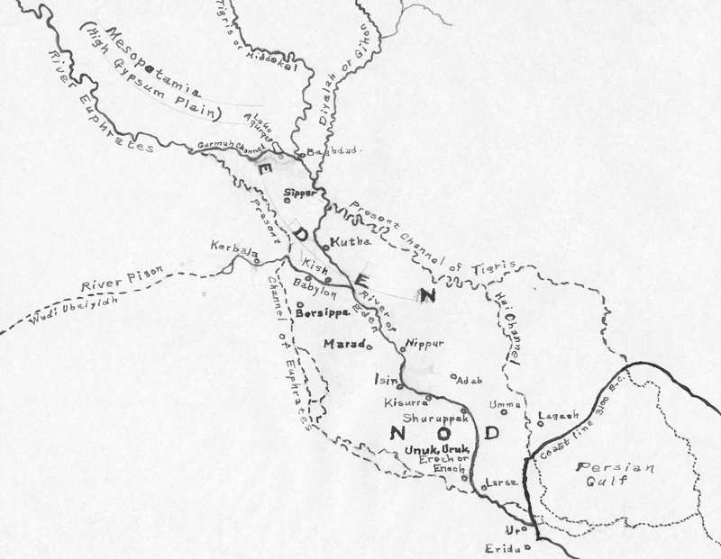
Eden Located
This point at which the waters of the four heads finally united into one must have been, by our text in Genesis 2, and by our theory, within the confines of the Land of Eden. Probably the name Eden would include the entire region up as far as where the Euphrates joined the Tigris by Baghdad. The four river heads having combined in the Kutha Channel would then follow that channel on south-easterly as “the river of Eden.” On the banks of the river (the Kutha Channel) the Garden of Eden would be located, being “eastward in Eden.” This would be between Kish and Nippur, nearer to Kish than to Nippur.
In later history, after the rivers had changed their courses, the combined waters of the Tigris and Diyalah diverting to the north via the present Tigris course to Kut, and thence down the Hai Channel, the Euphrates diverting westerly, the name “Eden” would be left in the middle, with rivers to the north and south of it. Thus it would come to mean the plains between the rivers. And although scholars have rejected as untenable A. H. Sayce’s proposal for the site of the Garden of Eden as being at Eridu (Abu Shahrein), still his remarks on the name “Eden” seem to hold good. Writing on “Eden”, he says on page 643, Volume 4, “A Dictionary of the Bible,”(ed. J. Hastings, Scribner 1911):
“The cuneiform inscriptions have cleared up the geography of the garden of Eden. The Sumerian name of the plain of Babylonia was Edin. This was adopted by the Semites under the name Edinu. “Its Assyrian equivalent was Zeru, corresponding to the Arabic Zor, the name still applied to the depression between the Tigris and Euphrates.”
Thus we find that the region we are driven to by examination of the text of the Scripture in relation to the four river-heads, as being the location of Eden, is confirmed and supported from the cuneiform writings of ancient Babylonia.
The river courses we have suggested above are set out on the map below.
Map of Edom
However, the reader is warned that these are suggestive only, pending light from further research and study. Nevertheless, whatever illumination may be gathered in the future on the subject, the degree of support from every direction for our theory seems strongly indicative that we must be at least close to the truth.
A careful examination of the map above will bring out still another remarkable feature. We stated before that the view-point of the writer of Genesis 2, appeared to be that of one looking upstream from the garden and describing the sources of the river coming out of Eden. Now, following on our map, upstream from the garden we find the branches of the river come in the following order:
\ No.1, the Pison, coming from Wadi Ubaiyidh
\ No.2, the Gihon or Diyala coming in from the north
\ No.3, the Hiddekel or Tigris
\ No.4, the Euphrates itself.
Turning back to our text in Genesis, we find that this is precisely the order in which the ancient writer named the four sources: He not only names the four in the same order, but actually numbers them, as if to make us recognize that he is giving them in the exact order in which they will be met when following up the river.
I must confess that the fact of the numbering of the river-heads in the text had no meaning for me until I first sketched the map above. Then it dawned upon me that the branches from the river were in the same order as in the text. Needless to say, it was most thrilling and elating to discover this quite unexpected confirmation.
More than a Myth
Having now ascertained what appears to be the correct location of the Land of Eden, and the approximate locality of the garden which God planted, it is obvious that the Genesis account is more than just myth. It has geographical reality. This begins to reflect genuineness, not myth. To those who have always believed the Genesis account it will be encouraging to see evidence that the story is more than myth. Those of the contrary part will have to admit at least that the setting of the story is a real, actual locality.
Is it not moving to be so very close to putting our finger on the very spot on the map which was the beautiful home of our first parents? To consider that here the first little sin was committed? It was such a “little sin”, just to eat a bit of fruit from one forbidden tree. Yet that “little sin wrecked the world. The little fox spoiled the vine.
When our first parents disobeyed their Creator, when sin first entered the human heart, it was almost the greatest and most heart-breaking tragedy ever to occur. “Almost” the greatest? Yes, almost, not quite. There is one greater tragedy.
Contemplation of the Eden story leads us to another story, the story of Calvary. There the Lord Jesus Christ took our sins in His own body on the tree and provided the only remedy for the sin story which began in Eden. His precious blood! He is the propitiation for our sins (the sins of His followers), and not for ours only, but also for the sins of the whole world (I. John 2:2). Was Calvary the greatest tragedy? No. Calvary, love’s supreme sacrifice and proof, was not a tragedy but a conquest. Calvary appears as a tragedy to those who have forgotten Eden. Without the tragedy of Eden, if man did not fall into sin, Calvary would be only a tragedy, and the greatest; but with the tragedy of Eden fully in view, that the human race is a fallen race and requires redemption, Calvary becomes the greatest triumph. What then is the greatest tragedy? It is this, to pass through life and miss the remedy of Calvary. Here every man who wills may find not only pardon for his sins, but an inward renewal to purity with the strength to withstand sin so that the tragedy of Eden will never be repeated within him. To miss that is the greatest tragedy, for, having lost this one and only chance, there is not another sacrifice that can be made. “For if we sin willfully after we have received the knowledge of the truth, there remaineth no more sacrifice for sins” (Hebrews 10:26). How good of God to provide Calvary as the answer to Eden.
Chapter Six: Eden in Relation to Geology
Turning back to the Land of Eden, let us consider it for a little from the viewpoint of geology. Can we locate the Eden story geologically, that is, where will it fit into the geologist’s scale. To what age does the record belong?
We do not feel that a final solution is yet available, but perhaps a few remarks will not be wholly out of place. These remarks will be exploratory only, awaiting fuller information in the future.
We know that the flowing waters of rivers will cut and erode channels for themselves. As a river picks up material in a place where it is eating out a channel, it will carry this material along while its waters move above a certain velocity, then deposit or drop it again where the waters move slowly. Rivers are thus a very important factor in the science of geology. Geologists have studied these actions of rivers with a good deal of care. By examining the geological strata near a river and noting what deposits the river has laid down, it has been possible for them to tell many an interesting story of events which transpired before there was a human eye to see them.
Some river valleys go a fairly long way back, geologically speaking; others are fairly new. One time I had the privilege of descending into the Red Deer River Valley in Alberta, Canada, at a point where the valley is deep and narrow. I had not been there before, but had heard of the dinosaur and other fossil remains found in parts of the valley.
As I looked up at the high, precipitous walls of the valley, I said to myself, “This valley must be of very recent formation.” It aroused a curiosity in geology. Later the matter was discussed with a geologist and he not only agreed with my opinion, but proceeded to explain much of how the valley came to be formed. Thus a thirst for some knowledge of this very interesting subject was stirred.
One would appreciate a very detailed supply of data on the geology of the lower Euphrates-Tigris valley before venturing too far in expressing opinions on that region. However, gathering up such information as at hand we suggest that the Euphrates River goes quite a way back into the past, from the geological view.
For those readers not acquainted with geological terms, may we just briefly explain that before this present time, geologists inform us there was the Pleistocene Epoch frequently referred to as the “Ice Age” or “Ice Ages” as it had cool phases during which, in northern parts of the earth great ice sheets formed. Prior to that was a relatively warm period known as the Pliocene, and before that the Miocene. That is as far back as we need to go for this Discussion.
What Rock Strata Lay Beneath Adam’s Feet?
A friend who was resident in the City of Baghdad for some time, told me he noted outcrops of the deep Miocene formation between Baghdad on the Tigris river and Musayib on the Euphrates. The latter place is almost straight south of Baghdad. Again, there are outcroppings of the same strata not far From Hillah, which is close to ancient Babylon, also at Najaf, and west of Basra. From these indications it seems that the Tigro-Euphrates Valley has been cut and eroded down into the Miocene formation from some higher level. If this is right, we might surmise that this happened during either the Pliocene Period or the Pleistocene Epoch (Ice Age).
The important point to be drawn from this is, that whatever may have since occurred by way of river deposits, re-erosion and re-deposit, the fact remains that Miocene formations and all previous strata lay beneath Adam’s bare toes. Those earlier ages or eras had come and gone ere Adam drew his first breath. Thus certainly, at least the Miocene Age and all previous ages ante-dated Adam, proven by the fact that Miocene formations underlie the Land of Eden. Closer examination may even prove that the next age after the Miocene, that is, the Pliocene, also ante-dated Adam, but of this we are not dead certain without fuller geological data.
There are those who subscribe to the theory of “Flood-Geology.” This teaches that nearly all the geological strata were laid down in one huge, global catastrophe, the Noachian Deluge. Now the relationship between geological formations and the Flood of Biblical history is as yet by no means a clear picture. There is a real need for a close and precise examination of the evidences on this subject. The late Dr. William Bell Dawson of Montreal told me he felt there was an urgent need for someone to make this their lifework. It would require one who is an earnest believer in the Scriptures on the one hand, and well trained in geological learning and observation on the other. So far, no one seems to have accepted the challenge.
The “Flood-geologists” have accomplished some good in challenging and calling in question some of the orthodox geologists I surmises and suppositions, which were a bit too easily put forth and too readily accepted. The idea of slow and very gradual changes in the past has had a few rude shocks, so that the doctrine of uniformity has had to step back slightly in more recent years. It has been admitted that there may have been some sudden and violent changes in the past.
However, while that step-back is a healthy sign, for the clash of theory against theory causes us to the more carefully search for the truth, yet so very much still remains to be unraveled. But it does seem that if our identification mf the Land of Eden is anything like near right, then the main contention of Flood-geology is untenable. As far as the geology of that land is concerned, if it has any meaning, the first man strode atop the Miocene strata, and probably on Pliocene strata also, and these strata with all that again lays beneath them, could not possibly have been deposited by the Flood which occurred long after.
When, then, did Adam appear, in the geological sense? Tossing aside for the moment all date-setting and all time estimates of the geological ages, from the evidences we have so far called up, Adam would come somewhere between the end the Miocene Epoch and the commencement of the present age. Two Epochs intervened here; the warm Pliocene and that mysterious, cool Pleistocene (Ice Age). This reply will be far too broad to satisfy many, but it is better to leave it thus for the present. We will have a little more to say on this in the next chapter, but the final answer awaits much fuller research and study.
Chapter Seven: Eden and Biblical Chronology
Chronology is the science of establishing the correct sequence of events and ascertaining the lapse of time from one event to another, in short, the setting of dates. The Bible is a unique book in that it is the only complete one preserved out of the past which gives a continuous, connected story from the first man down to the Greek era of history. Consequently, many have used the Bible as a basis upon which to construct a chronological system reaching back to set a date for the Advent of Man upon earth. However, the results have not been unanimous or conclusive. There are points of divergence of opinion, such as the duration of the Period of the Judges in Israel, and the length of the sojourn of the Children of Israel in Egypt. But these divergences dwindle to insignificance when compared with the enormous difference between the date for the first appearance of man in Biblically based chronologies and the dates given by geologists. The date for Adam is given by the one as about 4,000 B.C., or perhaps 5,OOO or even 6000 B. C. while the geologist puts the advent of man perhaps one million years ago. Is there any hope at all of this fantastic gulf of difference being satisfactorily bridged? In our present state of knowledge possibly, No; but we believe the difference will some day vanish.
Let us be patient, for in due time the real truth will be manifested.
The Date of Menes in Egypt
It is not many years since the science of archaeology arose and with it came a conflict of dates. Archaeologists dated Menes, the first king of the First Dynasty of Egypt, as before 5,000 B.C. That made Archbishop Ussher’s date of 4,004 B.C. for Adam, the first man, look foolish indeed. How could the date of a king, who presumably lived after the Flood, be earlier than the creation of the first man? Obviously, somebody was wrong. Ussher got the cold shoulder, and many at once discarded the Biblical account altogether. Was not the date of Menes given us by scientifically trained archaeologists? So Biblical chronology suffered a severe set back.
But what transpired afterwards? Other archaeologists came along, and further information was gained. The word “before” was erased, and Menes was “about” 5,000 B.C. Then more facts came to light, the “5” was erased and “4” written in, making Menes “about 4,000 BC. (What’s a thousand years anyway?) Soon that figure was found too high, and Menes sank down past 3,500 B.C. to “about 3,200 B.C.” Today his date is settling down to 3,100 B.C.
Now notice, additional light reduced the figure again and again, each time in the direction originally indicated by the Scriptures. What further changes the future will produce we do not know, but it certainly seems unlikely Menes date will be raised; if anything, it will likely be lowered again or remain stationary.
From this example we can see a remarkable trait of the human mind. A new science has a tendency to splurge with large pompous figures, to puff up with impressive accumulations of ciphers! Later facts prick these balloons.
Geology is a relatively new science as yet, and is full of big figures. How do we know but what future light will not drastically reduce and cut down these big figures? In fact, some figures have already under, gone reductions, such as the date for the end of the Pleistocene Epoch. Many still cling to as large a figure as they dare in this case, we suspect the reason to be the desire to envision a long period for the gradual development of early civilizations. An up-to-date encyclopedia gives the time as 25,000 years since the last Glacial phase ended, but we do possess some evidence contrary to such a large figure. For instance, the late Sir. J. W. Dawson, a geological authority, wrote:
“The elaborate and careful observations of Dr. Andrews on the raised beaches of Lake Michigan – observations of a much more precise character than any which, in so far as I know, have been made on such deposits in Europe – enabled him to calculate the time which has elapsed since North America rose out of the waters of the Glacial Period as between 5,500 and 7,000 years.” Re-quoted from Early Man in Scripture and in Science by David J. Gibson
A time between 5,500 and 7,000 years ago, would be in ordinary dating 3,500 BC and 5,000 BC. This is a terrific tumble down of dating: It actually means that the Glacial Period may have ended only 400 years before Menes, founder of Egypt’s First Dynasty, ascended the throne. This indicates that instead of the Neolithic (New Stone Age) and the “Copper Age lasting from 8,000 to 2,000 BC the span must have been vastly shorter.
The shortness of time since the last Glacial phase is confirmed by the Niagara Falls. As the Glacial ice melted, the Great Lakes stood at a much higher level than now. “Their outlet through the Saint Lawrence River was still blocked with ice, and they drained by various channels in part through the Chicago River to the Mississippi, in part by other outlets. At a later stage they drained through the Mohawk Valley into the Hudson River, and thence to the Atlantic Ocean.” (“Encyclopedia Americana,” under “Glacial Period.”)
Soon the waters broke through the Saint Lawrence channel and the mighty Niagara awoke as the waters thundered and roared over the escarpment, from their high post-Glacial level. The Mohawk Valley drainage outlet soon dried up as the water level fell. But the tearing flow of water at Niagara began eating away the escarpment. Gradually the falls worked their way back to their present location. Calculations based on the present rate at which the falls are retreating indicates that the falls have existed for only a few thousand years, something like 6,000 or 7,000 years; and if the volume of water was greater at first, when the level of the lakes is known to have been much higher, the period might be even less, as the wearing would be much more rapid with even a little more flow than the present rate. Everything of an exact and precise nature seems to emphasize the brevity of time since the last Glacial phase.
Such facts as the foregoing compel us to think twice before too readily accepting estimates of enormously long stretches of time for each phase of the Pleistocene Epoch. We feel some caution is required. Scholars of the evolutionary school of thought have wanted long periods of time in which to envision a slow, gradual progress of man from beast upward. This school is of the opinion that man appeared either late in the Pliocene or early in the Pleistocene, and the evidences support that point, as stone artifacts of middle and early Pleistocene have been found. Dr. Leakey’s find of “Nut-Cracker Man’ in the Olduvai Gorge in Tanganyika, Africa, has been widely acclaimed as the oldest known toolmaker. These fossils appear to belong to early mid-Pleistocene or to Lower Pleistocene deposits, and was dated by the finder as coming from 600,000 years ago. This is a large figure, but we must re- member that it is wholly dependent upon what view one holds as to the duration of the Pleistocene Period. If the Pleistocene began 1,000,000 years ago, then 600,000 would be not too far ahead of the middle of that figure; but if the Pleistocene was vastly shorter, then the date for “Nut- Cracker Man” would likewise be vastly reduced.
We must keep in mind that at whatever period science establishes the presence of man, then Adam was created either at or before that period. Adam was “the firs t man” (I Corinthians 15:45). No man could precede the “first” man, or he would not be “first.” The opinion on dates may violently clash, but dates are nothing but opinion-tags tied on by us to an event. Later information may force us to change the date tags, jus t as the date tag for Menes fell from “before 5,000 BC to “about 3,100 BC”
The idea that the Pleistocene lasted for nearly 1,000,000 years was built up largely on the conception of very slow changes in climate. But were all the changes so gradual? We do not have the ghost of an idea as to what caused Ice Ages during the Pleistocene, so how can we be sure the changes were gradual? The Encyclopedia Americana confesses:
“What produced this change is one of the most baffling problems in geology.” (Article, “Pleistocene Epoch.”) A hint that the changes were not too gradual is that it caused the extinction of many types of plants and animals. A very slow gradual change of climate would scarcely do this. In a slow change, succeeding generations of plants would shift or “migrate” to lower, warmer levels, and animals would gradually shift also. But a fairly sudden change would wipe out those not able to shift quickly. The article in the Encyclopedia Americana above quoted, speaks Of, “the extinction of types that could not migrate readily and in particular of the great mammals.” This looks suspiciously like fairly rapid change from warm to cold conditions. Again, the evidences of extremely high levels of rivers at times when the climate turned from cold to warm, hints at a fairly quick change back, not a long slow process. If a river had a rise of 12 inches only, average throughout the year, that would indicate a very significant increase in flow. A slow change, and not too slow, could cause glaciers to melt, retreat and produce such an increase in run off.
But when there is evidence of river levels being up 50 feet or more, the melting of the Glacial Sheets could not possibly have been such a snail-pace affair. The temperatures must have gone up by leaps and jumps.
Not long ago several papers carried articles on the suddenness with which the great pre-historic mammoths were frozen. They died and were frozen in before their flesh could begin to decay. One man told my father how he and another found one of these mammoths when digging for gold in the frozen subsoil of the far north. The flesh was perfectly preserved, stored these thousands of years in Mother Nature’s deep-freeze. He cut off some of the flesh, fried it and ate it. That animal died suddenly and was frozen – and such animals do not live in cold climates. There must have been a sudden change. Why, scientists have discovered in the state of the flesh evidences that these huge animals were suddenly frozen, frozen so suddenly that normal changes in flesh which is cooled gradually did not have time to take place. Some of them died so suddenly they did not have time to swallow the food in their mouths– some appear to have been frozen standing on their feet. What happened, I do not pretend to be able to say, only that it appears so intense a cold instantaneously descended upon these animals that they were killed and frozen before their muscles relaxed. Gradual, slow change over a period of a thousand or two years? Well, certainly not” in these cases, and how can we be sure about other climate changes during these phases of the Pleistocene?
Such factors as these seriously call in question the date tags the scientists have been wont to tie onto the various phases of the Pleistocene Period. Surely no one will deny that I have some ground for hesitancy over those date tags, and suspect that we will see some drastic reductions made before too long.
The Biblical Side
On the other hand, we do feel that many who have constructed chronological systems from the Biblical data have sometimes over-looked one very vital factor, for the times from Adam to Abraham. We have in this period or these periods, only the genealogies recorded in Genesis, and other parts of the Bible. These genealogies run thus, BEM so-and-so lived so many years and begat such-and-such a son, the son lived so many years and begat thus-and-so. It seems all we have to do is add the years together for a complete chronology of the time. This is so simple. But wait a minute: It is too simple: There are factors involved which so show us a true chronology is not gained quite so easily.
It comes as a distinct surprise to many, to be told that the genealogies in Genesis 5 and 11 are not complete. The Bible itself makes this clear, as we will show presently. To the Hebrew mind the words in these genealogies conveyed certain meanings which we are inclined to miss. When it is written that so-and-so begat such-and-such to the Hebrew mind this statement includes much more than a direct father and son relation- ship. If such-and-such was the direct son of so-and-so, to the Hebrew at once mind this meant that so-and-so was/the father both of such-and-such and of all succeeding generations following, what we call grandsons, great- grandsons, great-great-grandsons, and so on. The Hebrews had no words for “grandson” or “grandfather,” etc. Thus our Lord Jesus Christ is cal1ed “the son of David” in Matthew 1:1 although over 28 generations intervened! The birth of a child included not only the birth of that child but, in a sense, of all the future generations too.
Let us put it another way. A lives 40 years and begets B, then B lives 40 years and begets C. C lives 40 years and begets D. How many years from the birth of A to the birth of D? 120 years. But the ancient Hebrew writers might record A lived 40 years and begat D, entirely omitting any reference to B and C. To their way of thinking, the birth of B involved the birth of both C and D, and B and C might be omitted if they were unimportant or their memory less desirable, etc. The Hebrews were not trying to construct a chronology, but to give sufficient names down the line of descent to identify the family tree. Thus, how many names are omitted in these genealogies is anybody’s guess. We do know that at least one generation was omitted between Arphaxad and Salah in Genesis 11:12, because Luke names him in Luke 3:35-36. How many more names were omitted no one today knows.
Again, Jude 14 tells us Enoch was the seventh from Adam, proving positively that the genealogy in Genesis 5 is incomplete, for there Enoch comes in sixth. Some try to get around this, by including Adam’s name, and make Enoch the seventh name. By that is definite not what the text states. It says, “from Adam.” We are thus forced construct a chronology something like this:-
\ Adam lived 130 years to birth of Seth; (1st from Adam)
\ Seth…….. 105 ………………….Enos; (2nd from Adam)
\ Enos ……….. 90 ………………..Cainan; (3rd from Adam)
\ Cainan…….. 70 ……………Mahalaleel; (4th from Adam)
\ Mahalaleel….65 ………………….Jared; (5th from Adam)
\ Jared……….162…………..(Unknown); (6th from Adam)
\ (Unknown)..100?……………….Enoch; (7th from Adam)
This table destroys any exact chronology, but is likely nearer the truth. Many names might have been passed over in silence between Enoch and Noah. The final result of these considerations is that the time from Adam to Abraham may have been far, far longer than various Bible chronologies have made it. With this evidence for lengthening Biblical chronologies on the one hand and the evidences we cited before hinting at the need for drastically cutting down the date-tags on the Pleistocene phases, we see some hope of a final agreement. For the present it may be proposed that the Pleistocene Period roughly corresponds with the Antediluvian Age recorded in Scripture.
Chapter Eight: Cain’s City of Enoch
Now that we have arrived at what seems to be a reasonable opinion as to the location of the Land of Eden, the identification of the four river-heads and the approximate site of the Garden of Eden, it should be possible from this to know where to look for the next-door region, that is, the Land of Nod to which Cain went after he was revealed as the murderer of his brother Abel. The Scripture account states:
“And Cain went out from the presence of the Lord, and dwelt in the Land of Nod, on the east of Eden.” –Genesis 4:16.
It is to be noted that “the presence of the Lord” was in Eden. Here, in the infancy of the human race the Lord’s presence is connected with a place. Many think the place was the entry to the Garden, where the Cherubim stood with a Flaming sword. It is generally assumed that to this sacred spot the people brought their sacrifices, as we read of the offerings of Cain and Abel. At this place God spoke directly to the worshippers and the worshippers spoke to Him. From this place Cain was driven and cut off for life.
Cain dwelt thereafter in the Land of Nod. It was “on the east of Eden,” an expression which seems to mean adjoining it. Therefore, it was not far away. Here in due time Cain’s son Enoch was born. As Adam’s family increased in Eden, and Cain lived in fear that “everyone” there sought his life for slaying Abel, he hit upon an idea. He enclosed and “fortified” his residence, for self protection. This is the primary meaning of the word, “city” in Hebrew. It did not at first denote size, but an enclosed, fortified place. Cain may merely have erected a wooden palisade about a few huts, but this was new, it was novel, it deserved a name. He named it after his son, “Enoch.” The record runs:
“And he builded a city, and called the name of the city, after the name of his son, Enoch.” –Genesis 4:17.
Commenting on this verse, Dr. Arthur C. Custance relates a number of facts which we here quote almost in full.
“The subsequent history of this city we do not know: but of the name of the city we know a very great deal. Without entering into too much detail regarding changes in pronunciation which occur in the course of the development of a language, it seems necessary to point out here that the sound represented by the letter N is often reproduced (strange as it may seem) as an R. The CH sound which terminates the name Enoch may be replaced by a K or G, or a GH.
These changes are very common. When cuneiform was being deciphered for the first time, it soon became apparent that some of the cities mentioned in Biblical antiquity were still in existence as mounds and very often the natives in the area had preserved the original name in a modified form. A very important city in antiquity appeared under the name Uruk and a study of cuneiform soon revealed that this could equally well be pronounced Unuk, which was recognized at once by Sayce, and many others, as identical with the Biblical word, Enoch.
“One of the features of cuneiform writing was the use of what are called determinatives, signs which are placed before or after certain words to enable the reader to distinguish between names of cities and names of people, or names of deities and names of mortals, and so forth. Thus if a city happened to have a name which was also the name of a famous man, it was customary to use a determinative to let the reader know whether one was referring to the man or to the place. In the case of a man’s name, the determinative was put in front of the word; in the case of a … The interesting thing about the city Unuk, or Uruk, was that the determinative was omitted. It is the only instance in which this is so. The reason for this sole exception to the rule was not apparent at first until it was realized after considerable study of cuneiform texts that the word had come to mean the City par excellence, a special city, special for historical reasons.
And as such, it was not considered to stand in need of any distinguishing~ determinative. The ‘specialness’ lay in the fact that it was the name of the first City ever to have been built, and as such it was the prototype of all others and came to be referred to, to all intents and purposes, as The City - in somewhat the same way that people tend in England to refer to London as ‘The city’.
Now obviously the city which Cain builded and named after his son Enoch must have been destroyed by the Flood so that the physical entity itself probably disappeared, though it was subsequently re-founded. If the re-builders had followed our pattern, they might thenceforth have called it ‘New Uruk’. But though the original city was lost for a season, the name and the special significance were never lost sight of, for in time the name Uruk ceased to be a name at all and became merely a word meaning City.
In later cuneiform this city was known as Ereck, and at the present time the site is known by the local people as Warka. (Quoted by permission from Doorway Paper No.8, “The Confusion of Tongues,” 1961, pp.20-2)
One wonders, after reading the above, if Orientalists would have ever discovered the reason Uruk was written without the determinative sign apart from the help of the Bible. It is the Bible which tells us Enoch or Uruk was the first city.
Now Dr. Custance in the enlightening quotation given above seems to discount the idea that the postdiluvial city Uruk is the actual city founded by Cain. Even thought the first city was destroyed by the flood it seems to us that the re-bui1ders could have re-built on either exactly or very close to the original site.
A consideration which leads toward that conclusion, (if our readers can bear my once more referring to this principle,) is that Moses, or whoever it was who wrote the Eden story, used throughout names in current usage in his day. In fact, as far as chapter 2 of Genesis is concerned there is not one specific, geographica1 name used which was not in current use around 1400 B.C. It is to be doubted if the same principle will not hold for Genesis 4. If the name Enoch (Uruk) did not denote the same locality in 1400 B.C. as it did in the Antediluvian Age, then the author of Genesis 4 would be badly misleading his readers by saying Cain founded the City. He would feel impelled to insert some word of explanation that the city Enoch (Uruk) was not the same city so well known to him and his readers. Since there is absolutely no hint of such a distinction in the mind of the writer of Genesis 4, we feel it impossible to think he know of TWO places called Enoch or Uruk.
The Land of Nod
We previously mentioned that the Land of Eden apparently would be the land on either side of the Kutha Channel at least as far as Nippur. (See Fig. 7) Beyond this the path of the ancient river is marked by the sites of cities which sprang up along its course, Isin, Kisurra, Shuruppak and Unuk or Enoch. Possibly all these sites would be classed as in the Land of Nod, but at present we cannot define the boundary between Eden and Nod. It is interesting to note that the cuneiform story of the Flood makes the city Shurappak to be the home of Utnapishtim, the Babylonian name for Noah.
Now, as we look at the map in Fig. 7, the entire set up of localities, rivers, and names, very obviously falls into exactly the relative positions required by chapters two and four of the Book of Genesis. Can one doubt that this is the precise line-up which the writer of those passages had in mind, at the date he wrote? Would a reader living in 1400 B.C. put any other construction upon the geographical descriptions than we have done? If not, then our identifications must be very close to the truth of what the story intended to convey, from the geographical viewpoint.
Antediluvian Cities in the Cuneiform
We have listed the names used in the B1ble of antediluvian geographical features and one city. The cuneiform texts also recognize a sharp break in history as the Deluge, and even extreme critics are willing to acknowledge that there must have been some kind of a catastrophe to give rise to these stories in both cuneiform and Hebrew. The cuneiform texts also refer to certain cities as existing before this catastrophe, before the Flood. Five cities are specifically named, in one of the most important texts, namely,
\ Eridu – the city to which “sovereignty descended from heaven”
\ Badgurgurru – “fortress of workers in bronze”
\ Larak
\ Sippar
\ Shuruppak
With the possible exception of Badgurgurru these cities are located in the Babylonian plain. Thus the cuneiform concurs with the Hebrew Scriptures in locating the roots of antediluvian civilization as in that area. This joint testimony is significant, no doubt.
However, the postdiluvian picture is different. The Hebrew account depicts humanity starting out, not from the lowlands of Babylonia, but from the region of Ararat in the high Iranian lands. After going easterly from Ararat, the story seems to bring men in a circle, for later they entered the Babylonian plain again, journeying “from the east.” Does this hint that men circled around through the highlands because the Babylonian plain was still under water for several generations? However, having re-entered the plain from the east, the story of the ziggurat or Tower of Babel ensues.
The cuneiform historical texts simply state:
“The Deluge overthrew the land. After the Deluge had over thrown, the sovereignty descended from heaven – the sovereignty was at Kish. At Kish, Gaur was king” (Archaeology and the Bible, by Prof. George A. Harton, Ph. D., IVth ed., p.289; American Sunday School Union, Philadelphia.
Erech and other cities soon reappear, and evidently indicate the same city sites as in the text of antediluvian times.
Summary
We have now gone through the Biblical evidence. We have attempted to locate each antediluvian geographical name, and, with the aid of the cuneiform texts, we seem to have accomplished this task. Our hope is that the effort has not been in vain and will encourage much further research and
The End
Appendix 1
Are the names in Genesis 2 Postdiluvial?
One capable person questions my assumption in this matter, saying;: “You begin with ‘an argument from silence” – the weakest possible form of argument ever conceived. Your reasoning is that because there is no mention of the name Asshur prior to the Flood, it did not exist. How do you know? The fact that these names occur later in history means nothing. History tells us that old names are constantly re-applied to new places as they are founded, like London in Ontario, Berlin (now Kitchener) in Ontario, Hull in Quebec, and so forth. The United States in chock full of them.
If we did not know there was a Troy in Asia Minor, would a visitor to the United States, noting Troy on the road map, at once correctly say, “This name never appeared before the New World was discovered? Yet this is what your argument from silence implies.
In reply may we draw attention to factors favoring the view that such names are strictly postdiluvial?
The argument assumes that if Asshur was a man’s name and Assyria (a whole country) was named after him, yet could not this man have been named after an older predecessor and an older country? In short, there could be an antediluvian Asshur and a postdiluvian Asshur; possibly in entirely different localities. In view of the fact that we know many names are duplicated in history, the objection my friend raises is wholly valid; yet it is itself assumption. Thus we are dealing in opposing assumptions.
Now as to old names being applied to new locations, the reference to London, Ontario, is a most interesting example, named after London, England. Both Londons are on the banks of a river named the Thames; both are in a Middlesex county; in both cases by following downstream you will be drawing near to Chatham, though the Chatham in England is not on the Thames River as is the Chatham in Ontario. The parallels are numerous and striking, but they are limited. We soon discover sharp differences. The Thames in England flows easterly: the one in Ontario westerly, and so on.
If “Asshur” is both an antediluvian and a postdiluvian place name, we are immediately confronted with a vital question: Does the name in each case indicate the same place? The answer must be, Yes, or, No. If Yes, no differences will be observed in the description thereof, and our arguments on the whole will be little affected: if No, differences may be expected, and would be well nigh conclusive.
One might pile up Bible Dictionaries and commentaries from floor to ceiling which tacitly agree or plainly say, like Schaff’s Bible Dictionary, (11th edition, Studten4’s; American Sunday School Union), under the heading, “Assyria”: “A great empire founded by Asshur, Gen. lO:lO-ll, who built Nineveh “, etc. The thought of any other “Asshur” was foreign to these men of the past.
It seems, too, that the name “Asshur” in Genesis 2 is so related and tied-in with other names that it is virtually impossible to separate it from the “Asshur” of later history. It is related to the River Idiklat (Hiddekel), which settles it,– unless there were two Idiklats in ancient times, just as we today have two cities named— London, and two rivers named Thames. The Idiklat of Genesis 2 was part of an easterly-flowing drainage system, the same as we know the Euphrates-Tigris system to be,making it appear identical – unless there were not only two Asshurs, but two Idiklats and each connected with a distinct easterly-flowing system, both having in them a river named Euphrates: But the system in Genesis 2 is linked by another river (the Gihon) with Cush (Kassites), just as the Tigro-Euphrates system is linked by the Dijala river to the home of the Kassites, which should settle this point – unless we were confronted with two Asshurs, two Idiklats, two easterly-flowing systems, and two rivers connecting each to two places called Cush. And so on and so on. We could continue to stack up parallel relationships with historical conditions until the chances of the description in Genesis 2 being other than the later known situation begins to assume the most staggering proportions. We feel, at present, that the possibility of so much duplication is an assumption too big to be taken without some direct proof or evidence.
If we can agree to assume the identity of the location of the Asshur and other names in Genesis 2 with the locations known in later, historical times, then only the matter of the origin of the names remains in question. If these names (and others in Genesis 10) did not arise after the Flood, in relation to each other, as depicted in Genesis 10, but arose in a dim and distant past before the Flood, we know not just how, then of what value is Genesis 10 at all? If the people of Asshur were not named after their ancient leader, a man named Asshur; if Cush was not the founder of the Cushite tribes; if Havilah the son of Joktan was not revered as the father of the tribe of that name; if all these tribal groups existed before the men named in Genesis 10 were born – then must not Genesis 10 be discarded as a “Table of Nations”?
If the men named in Genesis 10 were named after older predecessors and after ancients clans and groups, then the grouping and relating of names in Genesis 10 is utterly valueless in studying groupings and relationships of ancient clans and tribes, since the clans and tribes existed before the men and their relationships came into being: We feel it far more satisfying to assume that all the names in Genesis 10 are intended to be taken as postdiluvial unless the text otherwise indicates.
One other point we should mention. When Moses, or whoever it was that compiled the Book of Genesis, he wrote down this river name Hiddekel (Idiklat). He had a concept in mind as to what river he meant by it. He expected his readers to have a similar concept. Suppose there was more than one river by that name; he would not want his readers confused on the subject. He may have been copying or drawing information from a clay tablet hoary with age, as some think.
It could be that the tablet before him spoke only the name Idiklat at this point, without defining which Idiklat was meant, assuming there two or more rivers of this name. If so, he may have added the explanatory phrase, “that is it which goeth to the east of Assyria.” In this case, “Assyria” to him would be the Assyria of his day, and the Idiklat we today know as the Tigris. But if the tablet before him bore the explanatory phrase, he copied it as it stood, evidently understanding it as applying to the Assyria of his day. As he added two qualifying expressions.
If I had been, say. Joshua’s grandson and wrote the new book “just off the press,” would not I understand it then to mean the Asshur of the time I lived in?
If there were two Idiklat Rivers and two Asshurs, then the qualifying phrase describing the river is useless. It would be like trying to explain which Thames River I referred to, by saying, it is the one which flows through London, and not tell whether I meant London, England, or London. Ontario. The writer of Genesis had more skill as an author than that.
If the descriptive phrase was added by a later scribe, (and I discount the idea), then the scribe evidently thought this Idiklat to be the one which flowed by Asshur of his day, in short, the Tigris. And who can prove he was wrong?
If the presumed clay tablet before Moses bore some older name or names, no longer in current use, and Moses substituted therefore names in current use at his time, Idiklat, Asshur, etc., then again we are forced to face the fact that we are handling postdiluvial or historical names in use during the second millennium B.C.
Thus whatever approach we make, we seem to be almost forced to treat the names in Genesis as postdiluvial, except for a few exceptions; Eden and Nod and Enoch may be older, etc.
Appendix 2
Maps, sketches and notes made by David J. Gibson before his death in 1964
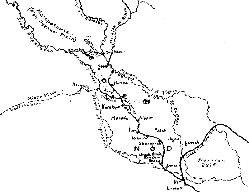
Map of Edom
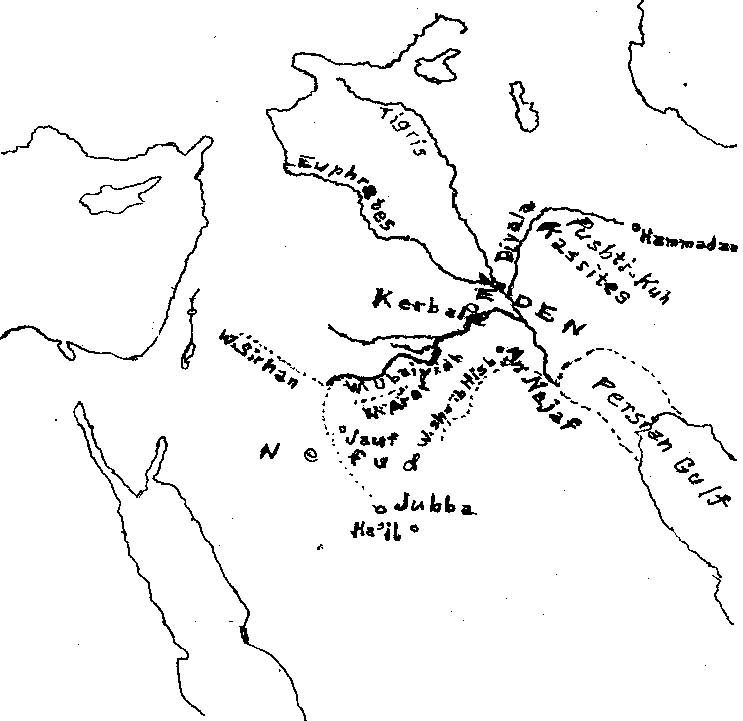
Map of Edom
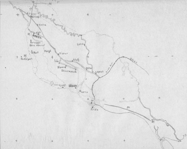
Satellite Image
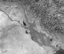
Rivers superimposed on Satellite Image
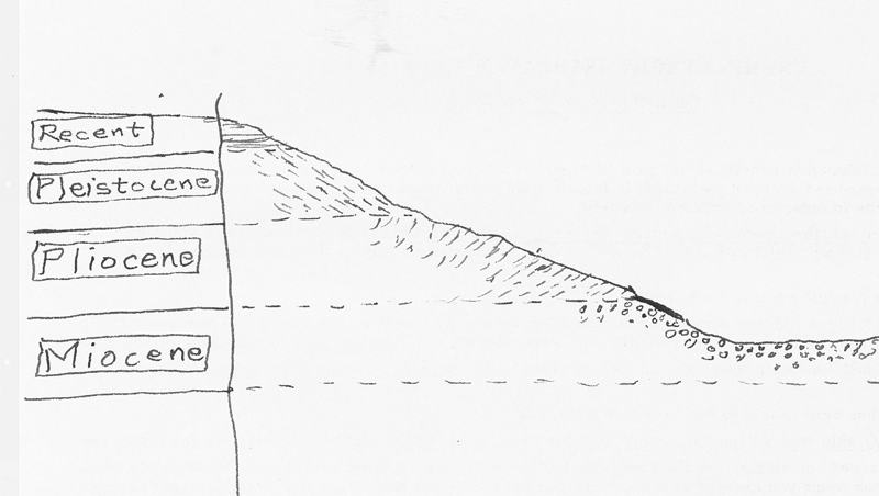
Geology
Copyright David J. Gibson & CanBooks 1964, 2004, 2019


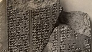


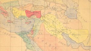

Page Discussion
Membership is required to comment. Membership is free of charge and available to everyone over the age of 16. Just click SignUp, or make a comment below. You will need a user name and a password. The system will automatically send a code to your email address. It should arrive in a few minutes. Enter the code, and you are finished.
Members who post adverts or use inappropriate language or make disrespectful comments will have their membership removed and be barred from the site. By becoming a member you agree to our Terms of Use and our Privacy, Cookies & Ad Policies. Remember that we will never, under any circumstances, sell or give your email address or private information to anyone unless required by law. Please keep your comments on topic. Thanks!