Click below to watch the video:
Dan Gibson introduces a new on-line tool that takes visitors on a tour through the Islamic places in Petra. Gibson explains that the original place names in Petra have been lost over the centuries, and that most of the place names are from the last several hundred years. Then using the descriptions of the earliest Islamic places, this tool takes the viewers through the Islamic places in Petra, including AlAqsa in Jiranah, Zamzam, the Ka’ba, the Cave of Hira, Arafat mountain, the Plains of Arafat, Muzdalifah , Mina, Jumrat, and the temple of Hubal and Alat. The tool can be found online at:
Transcript
Video #24 This is a general transcript of a Dan Gibson video in the series: Archeology and Islam.
Hello, I am Dan Gibson, and this is another video in the series Archeology and Islam. In this video, I would like to introduce you to an online tool that illustrates the various Islamic places that I have identified, in and around the city of Petra.
But before we do this, please note that almost all of the names for places and monuments in Petra today are not ancient names. The names of places in and around Petra are mostly names that have developed for these places, over the last five hundred years, while Petra was “hidden and forgotten” to the rest of the world. Monuments like the Treasury get their name from people who thought that the top of it contained a hidden treasure. So many early explorers and travelers used guns to shoot at it, to try and break it so the treasures would spill out. It only ended in damaging the facade.
The name Qasr al-Bint, goes back a ways in history, but it is not the original name of the structure. That has been lost to us.
One of the early names that has survived is Al-Baydha, which is a village north of Petra. Somehow it has maintained its original name.
But other names are descriptive, like the Palace Tomb, the Corinthian Tomb, the Urn Tomb, The Roman Soldiers Tomb, and the Great Temple, and many more. These are descriptive names that have been put onto these tombs and monuments. They are not the original names.
Even the names of the mountains have been lost to us, and today we only have the names that the local Bedouin have used, and those Bedouin tribes have changed over time.
For instance, the mountain with Aaron’s tomb on top is known today and Jebal Haroun. But that is not the ancient name. That has been lost to us.
The names of some places, like the Moses Spring seems to have been given after someone commented that it was like the rock the Moses struck and water came out. So it quickly became known as Ain al Musa, the spring of Moses. The original name was lost.
In fact, for many centuries, the entire city of Petra was lost, except to the local people who inhabited this ancient graveyard.
So over the years, I have been studying the Qibla direction of all of the Muslim mosques of the first century of Islam. From that study I have determine that the ancient city of Petra was the original holy city of Islam. Please use the online Qibla Tool to check out the mosques of the first two centuries of Islam. All of the original Qiblas faced Petra in Jordan.
Then, as we come to Petra, we can find many more indicators that Petra is the place that the early Muslim records spoke of. Please remember, that the name Petra is a modern name. It was given to the city by the Romans… and so the west has been using this Roman name… but the city of Petra had many names and descriptors down through history.
Originally it was Mount Seir. Later it was known as Raqim. It was also known as The Rock. That is Petra in Greek, and Hijr in Arabic. In fact there were two famous great rocks, Sela and Petra, so the region was known as Petrae; the place of the two rocks. The Roman province was called Arabia Petria, and it was managed from the city of Bosra in Syria, which was at the northern part of this province. Petra was also known to the Romans as Hadrianes Petra, as he is the one who first coined the term. The Romans also called it the Imperial Colony Antoniana.
The Roman emperor Blagabalus around 220 AD bestowed the tile: Mother of all Settlements, or Mother of all Cities on to Petra. In Arabic it was Umm Qurra. Others called it the Blessed or Noble city. These terms were all used in Greek and are attested in the Petra Scrolls.
The name Becca seems to have been used at the time of Abraham, as the name of the early valley, before it was settled by various tribes.
And later, around 600AD, a popular name for the city was Mecca. This is attested by Thomas Artsruni, a contemporary of Al-Tabari, who tells us that Mecca, The Mecca, was in Arabia Petrea.
So my conclusion is that the city had many names, titles, and descriptors over the centuries. When we come to Islamic literature, the name Mecca is used for both locations.
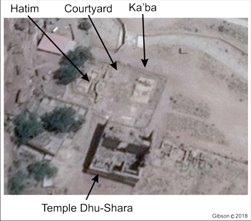
Location of the original Ka'ba in Petra
For example, some descriptions of early Mecca tell us that the Ka’ba was built near the corner of the Ka’ba compound, the hijr wall going all around the compound. We can see this clearly in Petra, where the Ka’ba is in the corner of the compound, and the Hijr wall curves around the Grave of Ishmael.
Later, in Mecca in Saudi Arabia, Ibn Zubayyr, moved the Black Rock to Mecca, and he attached the hijr wall to the Ka’ba structure. After this, Caliph Abdel al-Malik made sure the Ka’ba was in the centre of the compound, and not in the corner. We can see this at the Ka’ba in Mecca. In Islamic Literature, both places are called Mecca. And this is what has confused people all down through history.
So today, when people ask me to show them the name Petra in the Qur’an, all I can do is point them to the other names of Petra, including Um Qura, mother of all settlements, the blessed city, Becca, and even Mecca. The early Muslims did not use the Roman name which had been given to Petra by Hadrian some 400 years earlier. So in this video, we are going to go around the area, and look at places that correspond to the ancient descriptions.
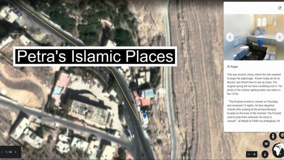
For instance, we are told that there was a place outside of the Haram area, where Muhammad would wash himself before going on the pilgrimage. We are told that he liked to stay at this spot. It was known as Jiranah, and there was a spring of water there. The spring was known as Al-Aqsa.
So when we start the Petra tool, we can see down in the left corner a guide. The first place on the guide is Al-Aqsa in Jiranah. Here we can see a photograph. We can click on the arrows and see several photographs associated with this site.
There is also description of this site. OK. Lets click on the link: It is at the bottom of the video.
Now remember that this tool is under development, so there may be some small changes, and additions over the coming months.
First, please allow time for the program to load. I think it works best on a desktop computer or on a TV screen. It is very difficult to see it on a cell phone.
Second, note that this link will take you away from where you are to a special program inside of Google Earth.
Next, close any pop-up windows, such as one that says Create Collaborative Maps. That link is inviting you to make your own map. But here we want to just examine the map that I have made.
Use the menu items on the bottom left to systematically walk through each of the places, or click on the blue markers on the map.
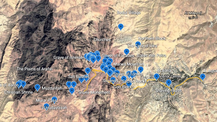
Places mentioned in the Petra Tool
As I said, the walk-through starts with Al-Aqsa in Jirana on the outskirts of Petra, and takes you along the pilgrimage route into the city. From there you can explore other places along the way that I have identified as important to Islamic history, or you can wander around and look at them yourself.
For each of these locations I have tried to include a quote from an early Islamic source if possible.
So what are some of the places? From Al-Aqsa in Jiranah, we move on to Al-Adna. This was a place for women to wash before starting the pilgrimage. Aysha used to start her pilgrimage from this point. It is closer to Majid al-Haraam, and the women would wash here before starting the pilgrimage. The men would either meet them here, or groups of women would talk together.
The third place is a map of the first day of the pilgrimage. The yellow line follows the 7-8 km walk into the city, around the Ka’ba and then to Mina. You can drag the map around to see where the route went.
The fourth place on our tour is the sacred rocks that marked the entrance to the Sacred Area.
Click through the photos, and then read the sources that describe the borders to the sacred area. Note that there are around 20 of these large square blocks all around the city, especially at the entrances that marked out the sacred area.
If you know of another quote from the Qur’an, a hadith, or one of the histories that would fit there, please let me know.
Place #5 points out a place along the route that was important to the polytheists. It was a tomb of a Nabataean merchant family, and has Egyptian like construction to the upper tomb, and Greek like decorations on the lower dining hall.
There are two photos of the dam next: first, another stone marking the boundary of Masjid al Haraam, then on the left the dam. This was important to divert flood water away from the heart of the city, and through a short tunnel carved through the rocks which takes the water away up to the north. Number 7 takes us into the thaniyya, or crack through the mountain.
I am not going to take you through all of the places. There are over 50 of them. But I invite you to come back to this tool again and again to check these early sites. I will be posting more of them, as well as the ancient descriptions to help you see Petra through new eyes.
I believe that the original pilgrimage was here, and that all of the important places that are supposed to be around Mecca in Saudi Arabia were all here around Petra.
When the Black Stone and the Ka’ba were moved to Saudi, people began to name places around Mecca in Saudi Arabia that seemed to fit.
But in this tool, you can examine what I think were the original places. It is all here, Zamzam, the Cave of Hira, the Ka’ba, Mount Arafat, the plains of Arafat, Mina, the temples of Dushara-Hubal, and of al-Uzza, even a huge place that was leveled out for the Jumrat or stoning the pillar. You can find Muzdellifa, and all of the places named in the early records. And along side of them, are places that were important to the polytheists and even some that were important to the population of Christians that inhabited this site during the lifetime of Muhammad.
Please enjoy this tool. I hope it is helpful.
Dan Gibson
Page Discussion
Membership is required to comment. Membership is free of charge and available to everyone over the age of 16. Just click SignUp, or make a comment below. You will need a user name and a password. The system will automatically send a code to your email address. It should arrive in a few minutes. Enter the code, and you are finished.
Members who post adverts or use inappropriate language or make disrespectful comments will have their membership removed and be barred from the site. By becoming a member you agree to our Terms of Use and our Privacy, Cookies & Ad Policies. Remember that we will never, under any circumstances, sell or give your email address or private information to anyone unless required by law. Please keep your comments on topic. Thanks!